![]() by Tom Gurney
by Tom Gurney
Tom Gurney BSc (Hons) is an art history expert with over 20 years experience
Published on June 19, 2020 / Updated on October 14, 2023
Email: tomgurney1@gmail.com / Phone: +44 7429 011000
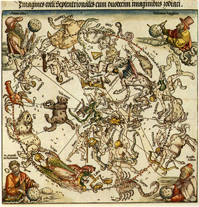
It was an Arabic technique of producing separate maps of the North and South Hemispheres and Albrecht Durer took this into his own maps
His Northern and Southern hemisphere maps were produced in Nuremburg in 1515 and many print reproductions have been made from them since.
Durer took inspiration from some charts found in his home town of Nuremburg in 1503 before adding his own twist. He frequently appended key individuals into the corners of his artworks and did just that here. Aratus Cilix, Ptolemeus Aegyptius (Ptolemy), M. Mamlius Romanus (Marcus Manilius) and Azophi Arabus (Al-Sufi) who are highly respected astronomers from previous centuries are placed into the four corners of this rectangular artwork.
Whilst serving the purpose of travel and direction, this map was clearly also of great artistic value. The flourishes, both artistically and symbolically make this an exciting strand to Albrecht Durer's extensive and varied career.
Traditional maps were beautiful, artistic items. Many now hang in museums and art galleries, just as Durer's Map of the Northern Sky with Representations of the Constellations found here, as sources of historical education in both art and travel.
Durer was proficient in a whole host of art mediums, including painting, drawing, woodcutting and engraving, but his work in cartography offers yet another avenue of interest and influence which is worthy of research and enjoyment.