

 by
Tom Gurney
Tom Gurney BSc (Hons) is an art history expert with over 20 years experience
Published on June 19, 2020 / Updated on October 22, 2026
Email:
tomgurney1@gmail.com
/ Phone:
+44 7429 011000
Map of the Southern Sky: Introduction
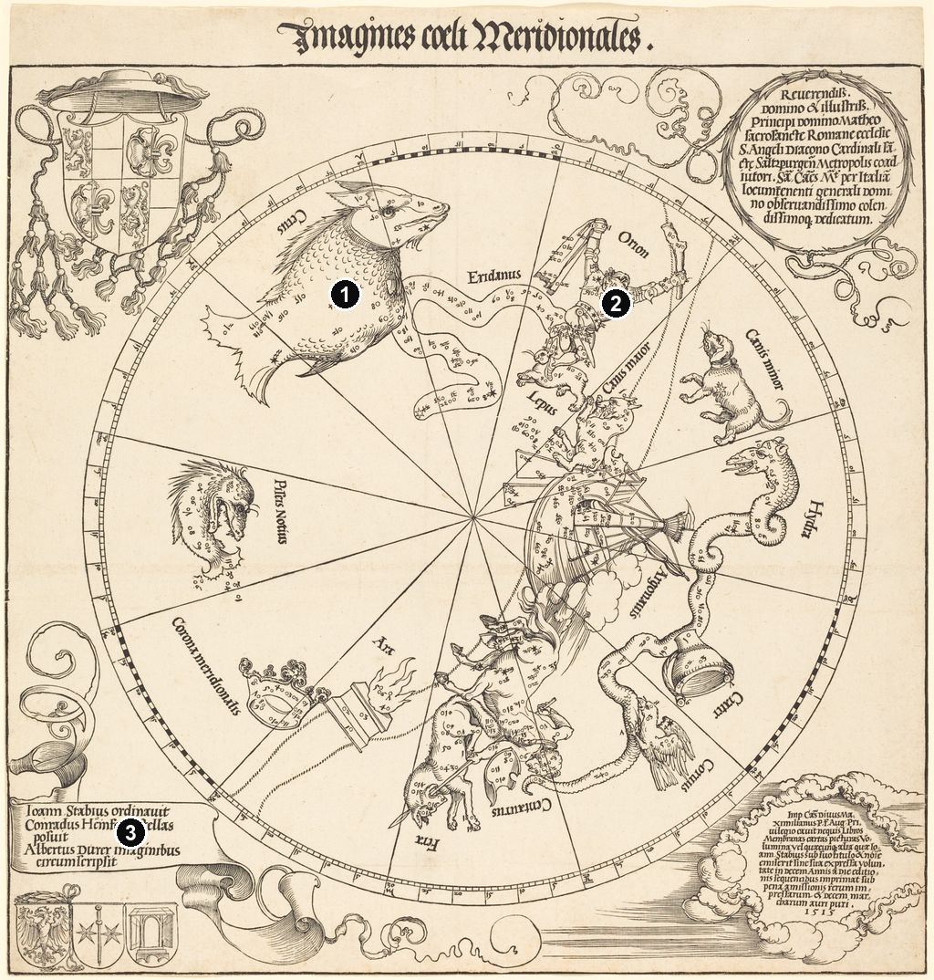
Albrecht Dürer’s Map of the Southern Sky of 1515 opens a surprisingly spacious view of the heavens. A great circle fills the sheet, yet much of its interior remains bare. A monstrous fish, a river, a hunter and a ship occupy this expanse alongside recognisable animals and a few strange combinations of bodies and objects. Fine straight lines pass through them towards a single centre. The woodcut belongs to a pair of celestial maps produced with Johannes Stabius and Conrad Heinfogel; its Latin title, Imagines coeli Meridionales , announces the images of the southern sky. Its stars, figures and inscriptions invite several kinds of reading at once. [1]
At a Glance
This work across Albrecht Dürer’s career
Young Hare
1502Praying Hands
1508Melencolia I
1514Four Apostles
1526Contents
- Looking into the circle
- Three makers and a dedication
- Printing under imperial protection
- Before and after the woodcut
- Frequently Asked Questions
Looking into the circle
The map uses a stereographic polar projection, with the ecliptic forming its circular boundary. The ecliptic is the Sun’s apparent annual path across the sky; the two sheets divide the heavens on either side of that circle. This explains why the southern sheet includes familiar constellations such as Orion. “Southern” here describes a division of the celestial sphere, rather than a chart restricted to stars visible only from the Earth’s southern hemisphere. The framework belongs to a mathematical system: the ring is graduated, and the lines radiating from its centre organise positions around it. [12]
The broad empty areas have a history. As Anna Friedman Herlihy explains, the classical constellation system drew on observations made at Mediterranean latitudes, where the far southern stars never rise above the horizon. A chart inheriting that system therefore leaves a large region unrecorded. Later voyages south would supply observations that helped fill the gap. The blankness of Dürer’s sheet records the limits of the information available to this tradition. Visually, it also gives the southern map an unusually open rhythm. Between the figures, the eye can follow a line uninterrupted for a considerable distance, seeing the structure that holds the pictures together. [13]
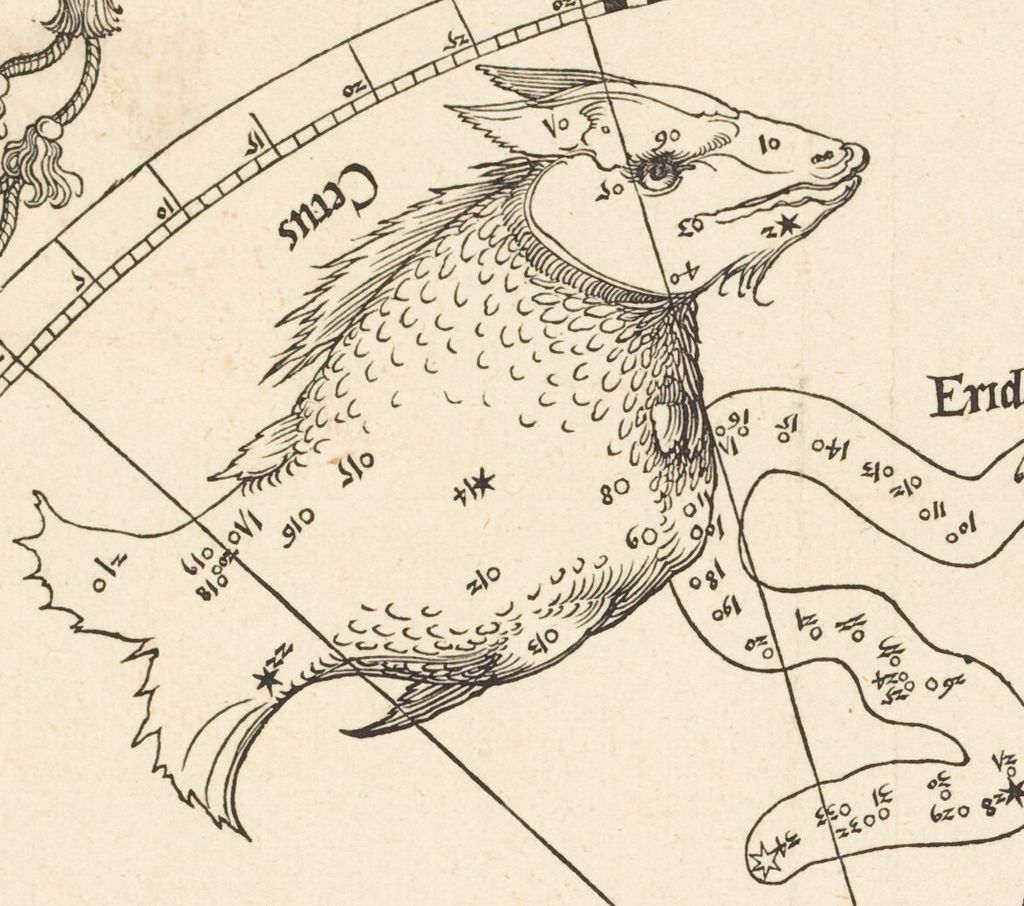
Cetus dominates the upper left. Its bulbous, scaled body, protruding teeth and fins give it the character of an invented sea creature. The head turns back towards the centre of the upper arc, while the tail fans out in the opposite direction. Below it, the Southern Fish, labelled Piscis Notius , curls almost into a ring. Both bodies contain small star signs and numbers. Their contours describe substantial animals, but the marks within them remain conspicuously separate: little circles and spiked stars sit on skin and scales without becoming part of their texture. [1]
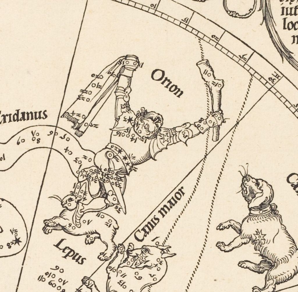
Eridanus offers another way to accommodate a constellation. The river runs through the space between Cetus and Orion as a winding band with a clear outer edge. It curls inward, then narrows and changes direction; numbers occupy its bends. Beside it, Orion raises his arms, holding a club in one hand and a hanging strip in the other. His body is fitted into a wedge of the chart, his feet directed towards the smaller creatures below. The hare has long ears, a rounded body and lively projecting legs. These details make the constellation readily legible as an animal even where its orientation on the page makes the figure look as though it is tumbling. [1]
The right and lower parts of the circle become more crowded. Argo is a ship’s stern, with rigging, steering oars and a high curving structure, emerging from a mass of cloud. Hydra snakes around it, carrying the cup, Crater, and the raven, Corvus. The Centaur occupies a broad section below, combining a human torso with an animal body and holding another creature. Nearby, the altar, Ara, sends flames into a narrow interval, while the Southern Crown closes another small patch of sky. These figures vary dramatically in scale and density. A ship requires taut straight lines and intersecting ropes; a snake can bend through the spaces between its neighbours. [1]
The numbers are essential to this relationship between figure and position. They correspond to the stars in the Ptolemaic catalogue, allowing the chart to be read against a textual system. Herlihy places the 1515 pair among the earliest printed charts to represent stellar patterns with scientific rigour. Looking closely at the southern sheet, one can see how much the image asks of the draughtsman: a recognisable figure must surround the specified marks while leaving them readable. The result alternates between the pleasure of following a creature’s outline and the slower business of finding a tiny sign within it. [13]
Annotated Details from The Southern Celestial Hemisphere
Compare the sea creature, the numbered stars across a human figure and the name panel at the lower left.
Details from THE SOUTHERN CELESTIAL HEMISPHERE
Open the details to follow the different kinds of line used for figures, letters and the map’s divisions.
A sea creature among numbered stars
The sea creature’s pointed snout and scaly body occupy a broad area of the circle. Small stars and numbers run across its body, alongside the larger lines dividing the map.
A human figure within the divisions
The human figure raises both arms, holding a broad rectangular shape on the left and a knobbly club on the right. Stars and numerals cross the clothes and limbs, fitting the figure into the surrounding divisions.
Names inside a curling panel
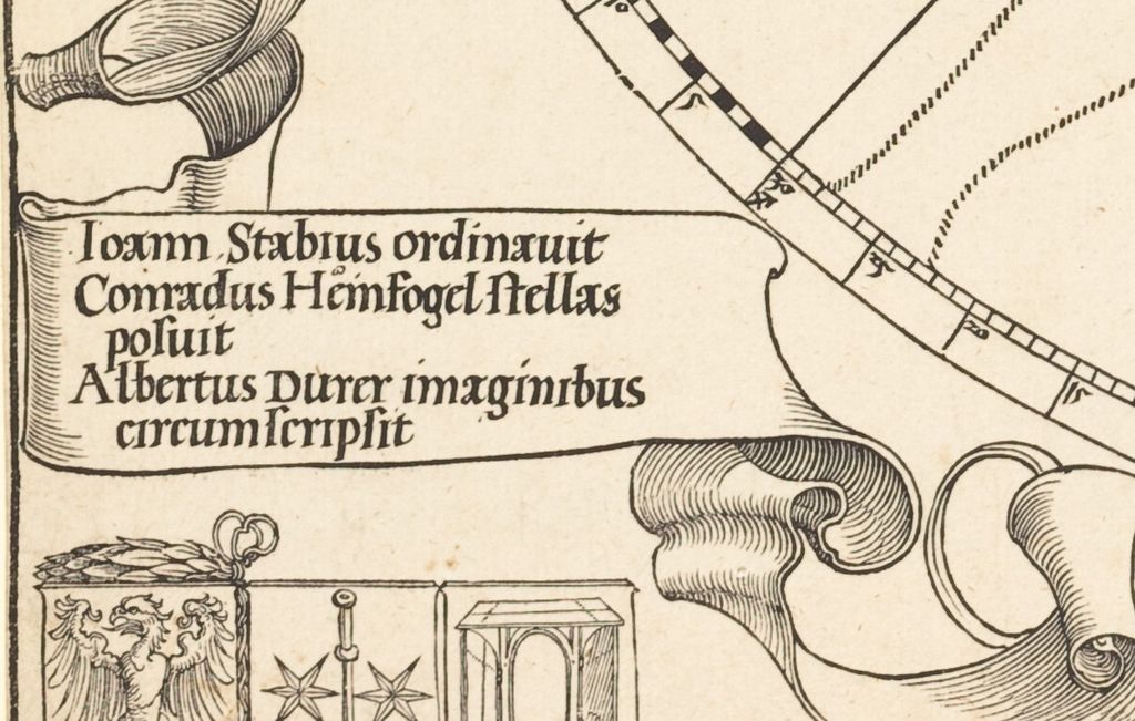
The names sit inside a curling panel beside the circular border. Long and short horizontal strokes give its folded edges a different texture from the letters.
Three makers and a dedication
The southern sheet gives unusually direct evidence of how its makers understood their contributions. At the lower left, above three shields, a broad curling ribbon names Stabius, Heinfogel and Dürer. The verbs distinguish their tasks. Stabius ordinavit credits Stabius with arranging or directing the work. Conradus Heinfogel stellas posuit says that Heinfogel placed the stars. Dürer’s contribution follows: imaginibus circumscripsit , surrounding them with images. Read beside the numbered bodies, that final phrase is particularly revealing. It describes the artistic task in relation to the stellar positions, giving the figures their place within a collaborative design. [1]
The ribbon itself is a small display of drawing. It rolls forward and back, changing from a flat writing surface into a shaded fold. Below, the three coats of arms place the participants together in a compact row. Authorship has a visible position outside the measured circle, as well as a written explanation. The inscription credits Dürer’s images, but does not identify the person who physically carved the printing block. Its careful division of labour lets us discuss the collaboration without assuming that one man performed every stage of manufacture.
At the opposite end of the sheet, ecclesiastical and imperial connections occupy the upper corners. Cardinal Matthäus Lang von Wellenburg’s arms appear at the upper left, beneath a broad hat with cords and hanging tassels. The upper-right dedication sits within an oval of intertwined branches. Its Latin identifies Lang as a cardinal, coadjutor of Salzburg and the emperor’s lieutenant-general in Italy, then addresses him with elaborate respect. The Kunsthistorisches Museum’s account of the maps identifies him as a close associate of Maximilian I. The dedication makes that powerful connection public; it does not, by itself, tell us that Lang commissioned the maps. [1] [14]
The difference in scale is striking. The cardinal’s single shield, hat and tassels spread across one upper corner; the three makers share a much smaller group below. Meanwhile, the circular chart presses close to both. Dürer’s border brings the social world of the publication into contact with the geometrical world of the heavens, without enclosing either in a separate decorative frame. Loose tendrils curl through the remaining white space, answering the more disciplined curves inside the map.
Printing under imperial protection
The lower-right corner contains the date 1515 and an imperial printing privilege. Within a billowing border of clouds, the Latin text names Maximilian and protects publications issued under Stabius’s name. It prohibits printing them without his express permission during the ten years following publication. The stated penalties include forfeiture of the printed material and ten marks of pure gold. Its scope extends through a list of books, parchment sheets, pictures and other publications. This is a substantial claim to control the reproduction of material that the printing process made repeatable. [1]
The wording also gives Stabius a different prominence from the shared authorial ribbon. All three collaborators appear together at the lower left, but the protection at the lower right attaches to what Stabius publishes under his name. Reading across the bottom of the sheet reveals both the making of the image and the management of its circulation. The clouds around the privilege look continuous with the ornamental world of the map, yet they surround a statement with an immediate practical purpose.
These arrangements extended beyond the two star charts. The ALBERTINA’s account of Stabius’s world map explains that the terrestrial map and both celestial sheets appeared in 1515 with dedications to Lang and ten years of imperial protection. The southern sheet thus formed part of a wider publishing enterprise joining Dürer’s draughtsmanship with Stabius’s cartographic work. Its crowded corner texts were part of how that enterprise presented itself to readers. [15]
Before and after the woodcut
A surviving southern star map of 1503 in the Germanisches Nationalmuseum helps place the print within a longer history. The museum assigns its drawing to an unknown artist and its invention to Heinfogel. At 66.9 by 67 centimetres, it is a substantial parchment sheet, worked in brown and red pen with opaque colour. Compass and other pinpricks remain part of its physical construction. Its corners contain an extensive humanist programme, including the Fates, Vanitas, Bacchus, and Sebastian Sprenz with Urania. According to the museum, the southern sheet suffered because it served as the outer wrapper when the pair was rolled together. [16]
That history belongs to the parchment drawing. The 1515 woodcut translated related celestial material into a different physical and public form. The genealogy is also more intricate than a single act of copying. Martin Roland’s study traces important figural relationships back to the Viennese star maps of 1435, while acknowledging that the exact means of Dürer’s access remains uncertain. The earlier maps establish a tradition in which astronomical information and drawn bodies already worked together. Dürer and his collaborators made their own publication within it. [17]
Individual impressions now preserve different encounters with the woodcut. Greenwich’s Caird Collection sheet measures 46.3 by 43.8 centimetres; the Rijksmuseum records its impression at 45.5 by 43.1 centimetres, on paper, with woodcut and letterpress printing. The Metropolitan Museum’s sheet measures 42.5 by 43.2 centimetres. Such measurements belong to particular surviving sheets, with their own edges and margins. They should not be treated as contradictory dimensions for one unique object. Colour, too, belongs to the history of an impression: the uncoloured National Gallery of Art example allows the network of black lines to remain especially clear. [18] [19] [20] [1]
The Louvre identifies its impression as the second state and points to the three stars on Orion’s belt as a distinguishing detail. It also records a collecting history that includes Abraham Ortelius, Pierre-Jean Mariette, Moritz von Fries and Edmond de Rothschild, whose collection entered the museum in 1935. These changing settings gave the chart further lives as a collected print. The chart’s long collecting history sets its astronomical subject within the preservation and study of Dürer’s printed work. [21]
Another southern impression travelled with an especially revealing group of maps. John Hessler’s Library of Congress account describes its former place in the volume assembled by the astronomer and globe maker Johannes Schöner, alongside Waldseemüller maps and celestial globe gores. The Dürer sheet was separated before the volume’s sale, then acquired by the Library in 2015, reuniting the dispersed contents within its collections. That association places the woodcut within a historical astronomer’s collection of geographical and astronomical images. [22]
Museo Galileo describes Dürer’s pair as models for numerous sixteenth-century celestial maps and globes. The southern sheet’s continuing interest lies in the particular balance it achieved. Its creatures give shape and memory to dispersed points; its lines make those points locatable; its empty spaces retain the limits of an inherited sky. Around the edge, names, arms, dedication and privilege explain who brought that sky into print and under whose protection it travelled. [23]
Frequently Asked Questions
Artworks directory
These 187 records include individual works, reverse sides, detail views, paired panels and reconstructed arrangements. Three additional catalogue images repeat works already listed. Related views are not counted as separate originals; qualified attributions and published dating are retained.
Discussion
Look again at the images and ideas explored in Map of the Southern Sky. These editorial prompts invite your observations.
Reader Insights
Which detail or idea in Map of the Southern Sky most changed your reading, and why?
How does the discussion of “Looking into the circle” affect your understanding?
What comparison would you bring to the discussion of “Before and after the woodcut”?
Join the Conversation
Share a detail, comparison or question about Map of the Southern Sky below.
References
- National Gallery of Art , The Southern Celestial Hemisphere , 1515, 1954.12.234. Collection record and primary woodcut, including Latin title, credits, dedication and imperial privilege. View source .
- ALBERTINA, Selbstbildnis als Dreizehnjähriger, inv. 4839 (German). View source.
- Metropolitan Museum, Four Horsemen from The Apocalypse, 19.73.209 (English). View source.
- Bayerische Staatsgemäldesammlungen, Selbstbildnis im Pelzrock, inv. 537 (German). View source.
- ALBERTINA, Feldhase, inv. 3073 (German). View source.
- ALBERTINA, Das große Rasenstück, inv. 3075 (German). View source.
- Metropolitan Museum, Adam and Eve, 19.73.1 (English). View source.
- ALBERTINA, Betende Hände, inv. 3113 (German). View source.
- Metropolitan Museum, Knight, Death, and the Devil, 43.106.2 (English). View source.
- Metropolitan Museum, Melencolia I, 43.106.1 (English). View source.
- Bayerische Staatsgemäldesammlungen, inventory 545: current collection record (German; descriptive citation). View source.
- Christina Posselt , “Sternkarte der nördlichen Hemisphäre”, Sandrart.net, annotation of 14 November 2011. German. View source .
- Anna Friedman Herlihy , “Renaissance Star Charts,” in The History of Cartography , vol. 3, part 1, University of Chicago Press, 2007, pp. 101–102, 111. View source .
- Florian Köhler , Una Matanović, Anna Nowak and Elisa Maria Wagner, “A new way of looking at the world”, Kunsthistorisches Museum, 2024, sections on the celestial maps. View source .
- ALBERTINA , Die Weltkarte des Johannes Stabius , DG1935/1019, collection record and text from Kaiser Maximilian I. und die Kunst der Dürerzeit , 2012, p. 202. German. View source .
- Germanisches Nationalmuseum , Karte des südlichen Sternenhimmels , 1503, Hz5577. German. View source .
- Martin Roland , “Die Wiener Sternkarten von 1435: Astronomie – Ikonographie – Stil – Gesellschaft”, Beiträge zur Astronomiegeschichte 13 (2016), pp. 41–46. German, with English abstract. View source .
- Royal Museums Greenwich , Imagines coeli meridionales , G200:1/6B. View source .
- Rijksmuseum , Hemelkaart van het zuidelijk halfrond , RP-P-OB-1494. Dutch and English. View source .
- Metropolitan Museum of Art , The Celestial Globe-Southern Hemisphere , 1515, 51.537.2. View source .
- Musée du Louvre , Carte du globe céleste : l’hémisphère australe , L 37 LR/321 Recto, record updated 11 April 2023. French. View source .
- John Hessler , “Mr. Dürer Comes to Washington”, Library of Congress, 6 November 2015. View source .
- Museo Galileo , Maps of the northern and southern skies , 2009 exhibition catalogue entry, Uffizi 5069–5070 st. sc. View source .
- Germanisches Nationalmuseum, Barbara Dürer (German and English). View source.
- Web Gallery of Art, Tucher–Rieter reverse (English). View source.
- National Gallery of Art, Portrait of a Clergyman (English). View source.
- Dürer Art, Portrait of a Man (English). View source.
- Hessen Kassel Heritage, Elsbeth Tucher (German). View source.
- Web Gallery of Art, Hans Tucher (English). View source.
- Germanisches Nationalmuseum, Emperor Maximilian I (German and English). View source.
- National Gallery of Art, Lot and His Daughters, reverse (English). View source.
- Bayerische Staatsgemäldesammlungen, Glim Lamentation (German). View source.
- Museo Nacional del Prado, Portrait of a Man (Spanish). View source.
- Bayerische Staatsgemäldesammlungen, Madonna of the Carnation (German). View source.
- Städel Museum, Job on the Dungheap (German). View source.
- Wallraf-Richartz-Museum, Piper and Drummer (German). View source.
- Italian Ministry of Culture / Uffizi, Head of Saint James (Italian). View source.
- Klassik Stiftung Weimar, Dresden Altarpiece (German). View source.
- Staatliche Museen zu Berlin, Girl with a Red Beret (German and English). View source.
- Dresden State Art Museums / Roland Enke, Bernhard von Reesen (German). View source.
- Royal Collection Trust, Burkhard von Speyer (English). View source.
- Dresden State Art Museums, Seven Sorrows of the Virgin (English). View source.
- Bayerische Staatsgemäldesammlungen, Mater Dolorosa (German). View source.
- Bayerische Staatsgemäldesammlungen, Lucretia (German). View source.
- Städel Museum, Young Woman with Her Hair Down (English). View source.
- ALBERTINA, Portrait of a Young Man (German). View source.