

 by Tom Gurney
Tom Gurney BSc (Hons) is an art history expert with over 20 years experience
Published on June 19, 2020 / Updated on October 12, 2026
Email: tomgurney1@gmail.com / Phone: +44 7429 011000
The Morteratsch Glacier, Upper Engadine Valley, Pontresina by Albert Bierstadt
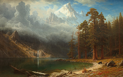
A green clearing opens between dark groups of trees towards brilliant snow and ice. Above it, jagged mountain forms rise into blue sky and cloud, while pale mist crosses the wooded slope on the right. Albert Bierstadt’s The Morteratsch Glacier, Upper Engadine Valley, Pontresina builds its view through these successive contrasts: rough foreground timber, sheltered woodland and an intensely illuminated Alpine distance.
The title identifies a Swiss subject associated with Pontresina. Here the mountains are approached through the valley’s vegetation, which occupies much of the lower scene and gives the viewer a place from which to look towards the brighter heights.
At a Glance
Where this painting sits in Bierstadt’s career
Dates refer to the paintings, rather than to the journeys behind them. Approximate dates and ranges retain the qualifications in the collection records.
Lake Lucerne
1858Mountain Brook
1863Street in Nassau
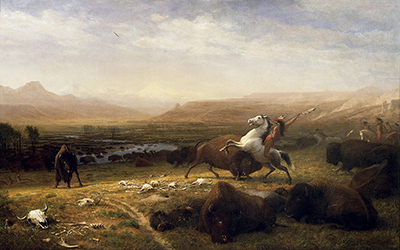
c. 1877–1880The Last of the Buffalo
1888–1889The Golden Gate
1900The Morteratsch Glacier, Upper Engadine Valley, Pontresina
Date unconfirmed for this reproductionContents
What the records establish
The Smithsonian’s Inventories of American Painting and Sculpture records a work with this title dated 1895, in oil on canvas, associated with Brooklyn Museum accession 03.69.[1] It also transcribes a Christmas dedication to Mary dated that year and names Mary Stewart Bierstadt as the donor.
The commonly circulated reproduction is likewise labelled 1895 and oil on canvas in its Wikimedia Commons record.[2] However, the measurements conflict: the inventory gives 72 by 120 inches (183.0 by 304.8 centimetres), whereas Commons gives 96.5 by 152.4 centimetres.[1][2] These are substantially different sizes, not small variations caused by rounding. Neither averaging them nor choosing the larger measurement would resolve the discrepancy. A current owner-issued record and image matching this reproduction have not been confirmed here. Exact dimensions and present collection status therefore remain unresolved.
The institutional inventory is evidence for the title’s history, but the dedication cannot yet be securely attached to the reproduced image through a verified owner match. Its precise site of execution and relationship to a particular field study also remain unconfirmed.
The clearing as a point of entry
Low vegetation, scattered stones and patches of shadow break up the nearest open ground. A fallen trunk crosses the lower-left foreground diagonally, its pale surfaces catching light against darker plants.
Standing trees on the left form a dense vertical boundary. One bare trunk has a markedly different shape from the conifers behind it: its broken branches extend into the sky, and its uneven outline stands clearly against the illuminated distance. This damaged form makes the near woodland more particular than a repeated screen of trees.
Towards the middle, a compact group of conifers interrupts the mountain view. Their dark crowns rise to different heights, overlapping both the bright slope and paler atmosphere. Smaller trees continue beyond them towards the left, suggesting that the clearing extends into a larger valley.
These interruptions slow the passage into the distance. The eye can move towards the glacier, but it also encounters individual trunks, roots and pieces of timber. The foreground supplies texture and scale before the brightest part of the landscape takes over.
Light across snow, rock and cloud
The brightest white and yellow passages lie beyond the trees near the centre-left. A pointed mountain rises above them, with alternating pale faces and darker divisions. Higher on the right, larger rock and snow formations appear through cooler blue-grey atmosphere.
The illuminated area does not have one continuous outline. Cloud passes beside the mountain forms, while darker rock interrupts the snow. This variation makes the distance difficult to reduce to a single white shape: some passages feel solid and angular, others diffuse and suspended.
On the right-hand slope, a low band of mist separates levels of wooded terrain. The ridge above it recedes into shadow, while small brighter patches appear lower down. This side of the picture provides a quieter transition between the near trees and the elevated mountain mass.
The sky also remains varied. Blue opens above the central view, while taller clouds gather towards the left and paler veils cross the upper right. These shapes continue the movement between clear forms and obscured ones already present among the mountains.
Morteratsch in nineteenth-century science
Morteratsch was a site of scientific observation as well as landscape imagery. In The Forms of Water in Clouds and Rivers, Ice and Glaciers, John Tyndall describes approaching the glacier from Pontresina and examining a band of debris that widened towards its lower end.[3]
His account of measurements made with Hirst in 1864 is especially relevant. They placed three lines of stakes across the glacier at different levels and recorded their movement. The upper line moved faster than the lower ones. Tyndall used the observations to explain how the debris band could spread as the faster upper ice pressed towards the slower ice below.
The measurements concern movement within the glacier, rather than a change in its front. They give motion to a subject that can appear still in a painting.
A long record of glacier change
Glacier Monitoring Switzerland’s report Revised Strategy for Monitoring Glacier Length Variation lists Morteratsch observations covering 1878–2018.[4] That historical span reaches back before the 1895 date associated with the painting.
The report explains that systematic Swiss monitoring used measurements from reference points in the ground exposed before glacier fronts. Simple measuring techniques helped sustain a wide network of observers; later methods included GPS and aerial imagery.
It also stresses that a glacier’s length responds to climate through interconnected processes, including ice flow and changing geometry. The response can be delayed, so an individual change in the front’s position cannot be read as an immediate measure of a single weather condition.
That distinction enriches the encounter with Bierstadt’s scene. The image brings together grass, trees, mist and bright mountain ice in one view. The measurement record follows a changing boundary over time. Each draws attention to a different aspect of the landscape.
Historical images and modern reconstruction
Historical photographs have also become evidence in glacier research. ETH Zurich’s account of a 2022 study explains how researchers used paired images from the Swiss national survey to reconstruct glacier surfaces.[5] The glass plates had been digitised with information from field books, allowing the positions and shapes in the photographs to be interpreted more precisely.
The researchers compared reconstructed surfaces with later data to calculate changes in ice volume. Their finding that Swiss glaciers lost about half their volume between 1931 and 2016 concerns the national glacier population, rather than a measurement extracted from this painting or a figure specific to Morteratsch.
The method helps explain why historical images require careful treatment. A calibrated photographic pair can support a spatial reconstruction. A landscape painting offers choices of viewpoint, emphasis, colour and arrangement whose relationship to exact measurements must be established separately.
An Alpine view held between trees
Return to the dark conifers near the centre. Their overlapping crowns conceal part of the mountains, making the distance appear through and around the woodland. The effect gives the foreground an active role in the scene rather than placing it below a fully exposed panorama.
From the fallen trunk, the view extends across the clearing towards smaller trees and the luminous mountain opening. From the right-hand woodland, mist leads upwards towards the shadowed ridge. These different routes make the painting rewarding to explore beyond its immediately striking area of white and gold.
Its interest lies in the relationship between those scales: timber close enough to examine, trees that divide the view, and glacier scenery that exceeds the foreground’s enclosure. The scientific history adds a further dimension, inviting attention to a mountain environment whose apparent stillness contains movement and change.
Watch: Albert Bierstadt
Five perspectives on his paintings and their historical setting.
American Landscape Painting: Albert Bierstadt and the American Land
A Museum of Fine Arts, Boston presentation on American Landscape Painting: Albert Bierstadt and the American Land.
Explore Bierstadt’s artworks
Discussion
Dark woodland frames the brilliant Alpine distance. How does the painting lead you from the fallen timber towards the ice?
Reader Insights
Which foreground forms make the clearing feel accessible, and which keep the snowy mountain at a distance?
What can the painting contribute to a discussion of glacier change, and what would require the measured records or historical photographs discussed above?
How do the bright ice, pale mist and shaded trees establish depth without giving every surface equally sharp detail?
Join the Conversation
Share a specific observation, documented connection or comparison from The Morteratsch Glacier, Upper Engadine Valley, Pontresina.
References
- Smithsonian American Art Museum. The Morteratsch Glacier, Upper Engadine Valley, Pontresina, IAP 35680043. Institutional inventory and transcribed inscriptions; exact match to the circulating reproduction remains unconfirmed. View source text
- Wikimedia Commons. Bierstadt Albert The Morteratsch Glacier Upper Engadine Valley Pontresina.jpg. Reproduction record; date and medium are secondary metadata, and dimensions conflict with the inventory. View source text
- John Tyndall. The Forms of Water in Clouds and Rivers, Ice and Glaciers, 1899 edition of the work copyrighted 1872, §35, paragraphs 240–248. Selected original account of Morteratsch observations, read through Project Gutenberg’s transcription. View source text
- Glacier Monitoring Switzerland (GLAMOS). Revised Strategy for Monitoring Glacier Length Variation. Selected pages 1–4 and appendix page 9: measurement methods, interpretation and Morteratsch’s observation series. View source text
- ETH Zurich. A historical perspective on glacial retreat, 22 August 2022. Research summary explaining historical photographic reconstruction; national findings distinguished from Morteratsch-specific measurements. View source text