


 by Tom Gurney
Tom Gurney BSc (Hons) is an art history expert with over 20 years experience
Email: tomgurney1@gmail.com / Phone: +44 7429 011000
Across Moat and Gallery: How Angkor Wat Turns Distance into Sacred Ascent
Angkor Wat is one temple inside the much larger archaeological and living landscape of Angkor. Built for King Suryavarman II in the first half of the twelfth century, it combines a vast moat, western causeway, concentric enclosures, narrative galleries and a rising group of five towers. Its stone sanctuary belonged to a capital sustained by roads, fields, reservoirs, canals and settlements whose domestic buildings were largely timber. [1] [13]
The monument was chiefly dedicated to Vishnu and later became an enduring Buddhist sacred place. Cambodian people did not forget it while European writers described a “rediscovery.” Colonial surveys, post-independence work, war, international safeguarding and current Cambodian stewardship have all shaped the fabric and its interpretation. [6] [15]
Contents
- Suryavarman II and Orientation
- Moat, Causeway and Approach
- Temple Mountain and Geometry
- Stone and Construction
- Narrative Galleries
- Devatas and Craft
- Greater Angkor
- Living Religious Continuity
- Survey and Conservation
- Pressure and Future Care
- Recommended Books
- Watch Architecture
- Why Angkor Wat Matters
- Evidence Tests
- Frequently Asked Questions
- Discussion
- References
Suryavarman II and a west-facing temple
Suryavarman II ruled a powerful Khmer empire and commissioned Angkor Wat as a royal state temple. Construction is usually placed between about 1113 and the middle of the century. Inscriptions and reliefs associate the king with Vishnu, warfare, court ceremony and cosmic order. [2] [13]
Most major Angkorian temples face east, but Angkor Wat's principal entrance and axial approach are on the west. Scholars have related this orientation to Vishnu, funerary associations and the direction in which some relief sequences are read. No single explanation resolves every feature; orientation remains an important, evidence-led question rather than a secret code. [6] [15]
The temple's Khmer name and continuing religious use complicate the idea of an isolated royal memorial. Monks, pilgrims and local communities adapted spaces after the imperial court changed. Images and shrines were added, maintained or replaced. A building can preserve its original framework while acquiring new sacred lives. [1] [6]
Moat, causeway and measured approach
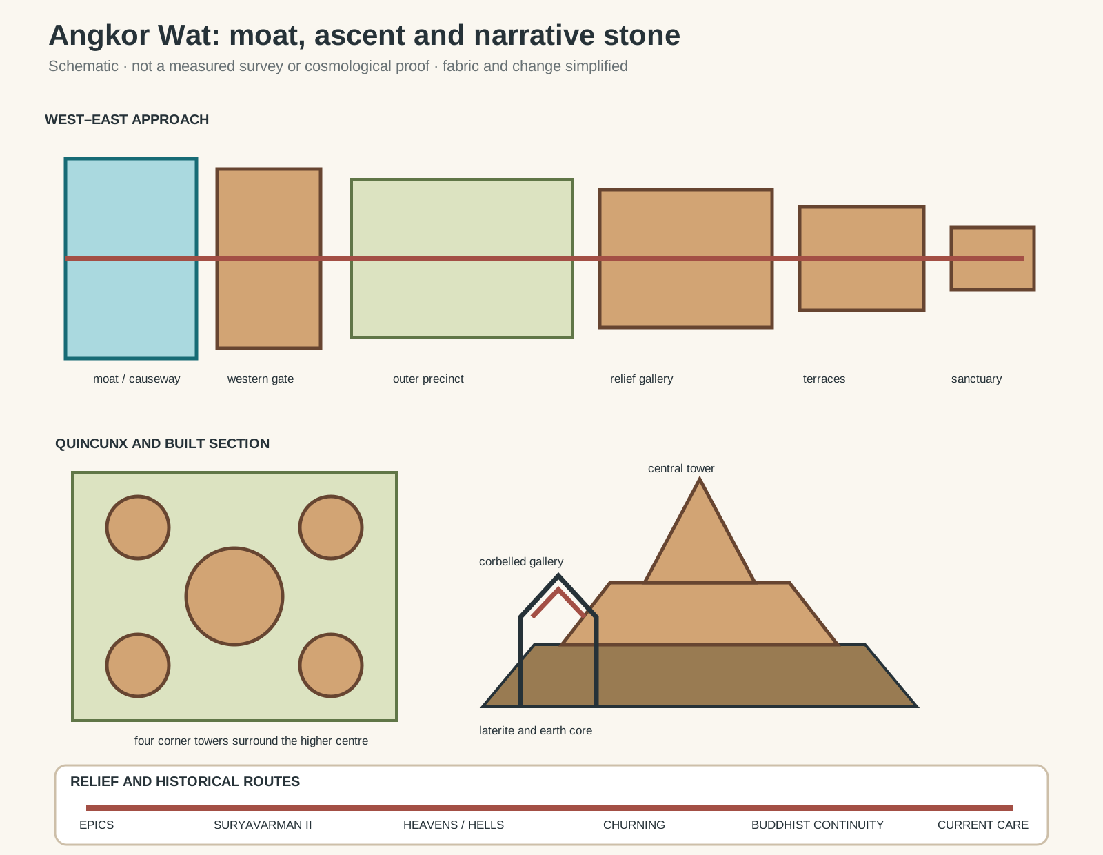
Original architectural reading diagram. Schematic, not a measured survey or cosmological proof; fabric and historical change are simplified.
Text alternative for the diagram
A west-to-east route crosses the moat and gateway, passes outer relief galleries and ascends three terraces to five towers. A plan marks four corner towers around the higher centre; a section distinguishes laterite and earth cores from sandstone surfaces and illustrates a corbelled gallery roof. A relief strip links the epics, royal procession, heavens and hells, and Churning of the Sea of Milk. Canals, fields and settlement mounds place the temple within Greater Angkor.
A broad rectangular moat creates the first enclosure. Water separates ordinary ground from the temple precinct, reflects towers and controls drainage around an enormous platform. Within Hindu cosmological readings it can evoke the ocean surrounding the central world mountain, but it is also a constructed hydraulic and territorial boundary. [13] [15]
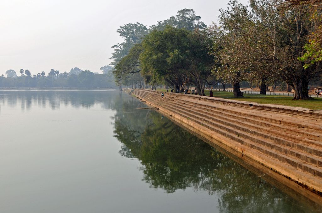
Stepped sandstone banks contain the still moat beside trees and visitors in Dennis G. Jarvis's February 2009 view. The photograph isolates the engineered water boundary; the causeway and temple lie beyond the frame, and present water and vegetation should not be treated as unchanged medieval conditions. Dennis G. Jarvis, Stepped sandstone bank of the Angkor Wat moat; CC BY-SA 2.0. JPEG prepared; no crop or retouch.
The western causeway crosses that water towards a long entrance gallery. Its width and duration delay arrival. The towers appear, disappear behind the gateway and return as the visitor passes into the outer enclosure. Architecture is disclosed in stages rather than presented in one instant. [6] [9]
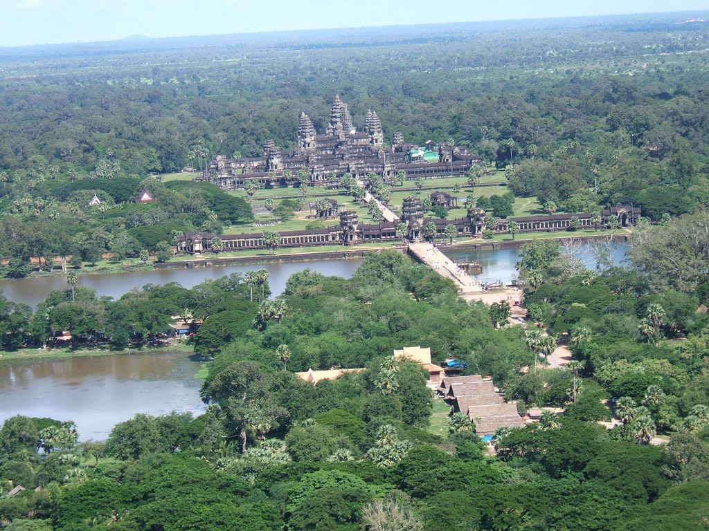
Angkor Wat's western causeway crosses the broad moat before a long entrance gallery, open precinct and compact central temple in shankar s.'s October 2008 balloon view. The aerial makes distance, enclosure and surrounding settlement landscape legible while remaining an oblique photograph rather than a measured plan. shankar s., Aerial view of Angkor Wat; CC BY 2.0. JPEG prepared; no crop or retouch.
Libraries, ponds and open ground occupy the large first precinct. What now appears as lawn did not exist outside social use: processions, attendants, shelters and maintenance would have animated the route. The central temple stands within an enclosure that managed movement at a scale larger than its stone rooms. [9] [15]
Successive galleries contract the route and raise its level. Steep stairs intensify the final ascent. From below, tower profiles overlap; from the upper terrace, the quincunx becomes legible as four corner towers around a taller centre. The bodily effort of climbing turns hierarchy into experience. [9] [13]
Temple mountain and architectural geometry
Angkor Wat belongs to the Khmer temple-mountain tradition. Its stacked terraces and central tower have been interpreted as Mount Meru and its surrounding peaks, with enclosures and moat corresponding to ranges and ocean. Such associations connected king, deity and ordered universe. [13] [14]
This framework does not make the monument a literal scale model of mythology. Builders responded to soil, load, stone supply, procession and visibility. Dimensions may carry symbolic relationships, yet cosmology worked through constructed form and ritual practice rather than replacing engineering. [9] [15]
The five towers form a quincunx. Each uses tiered, curving profiles assembled from horizontal stone courses, not a monolithic shell. Repetition makes the centre appear dominant while corner towers establish depth around it. [6]
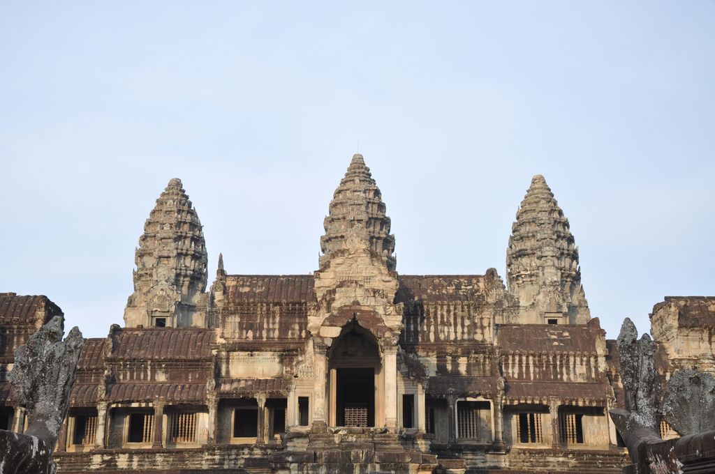
Three tiered towers rise above galleries and steps in Jorge Láscar's January 2011 view. Their overlap and weathered sandstone profiles convey the rising temple mountain, although three visible towers cannot by themselves demonstrate the complete five-tower quincunx. Jorge Láscar, Three towers of Angkor Wat; CC BY 2.0. JPEG prepared; no crop or retouch.
Doorways, galleries and courts align with the main axis, but access is not equally open. Differences in level, stair steepness and enclosure create progressively restricted domains. The ideal order therefore also embodies social ranking and control. [1] [2]
Sandstone surfaces and hidden construction
Visible walls, columns, lintels, galleries and reliefs are chiefly sandstone. Laterite, earth and other masonry form foundations, cores and less exposed construction. The finished monument depends on both prestigious surface and concealed mass. [9] [12]
Khmer builders created roofs with corbelling: stone courses project inward until the remaining gap can be covered. This differs structurally from a true arch, where wedge-shaped units transfer load around a curve. Corbelled galleries can achieve strong linear interiors but place particular demands on joints and drainage. [9] [15]
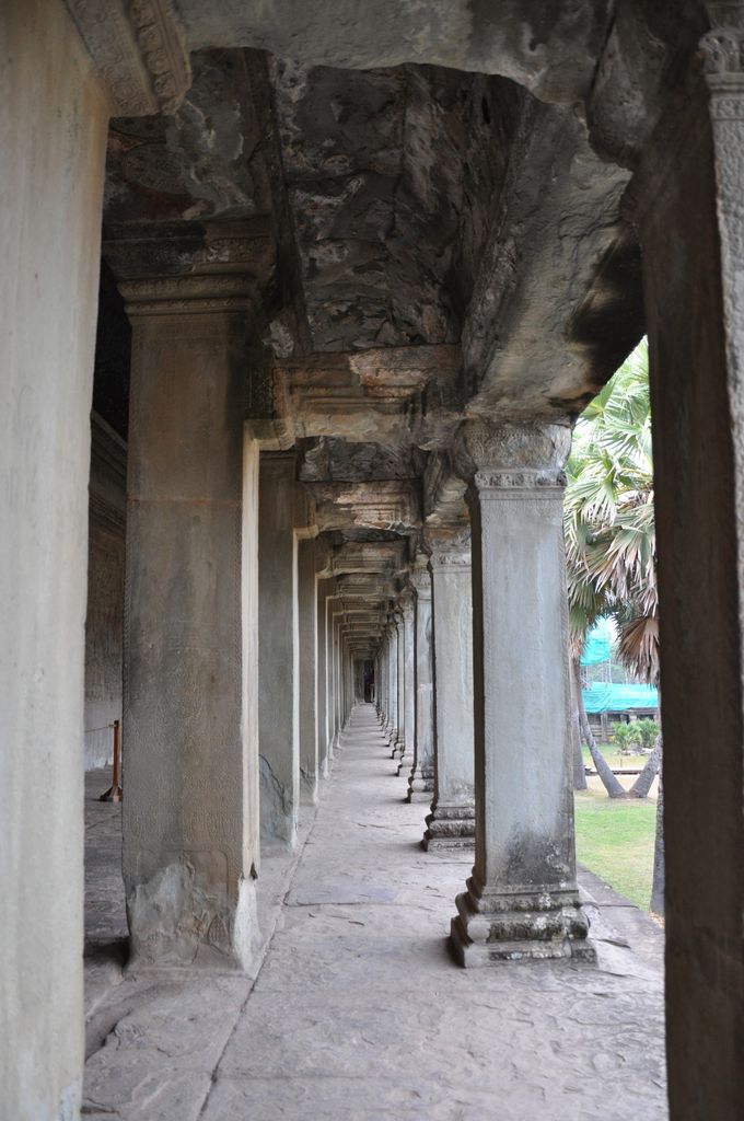
Repeated columns carry projecting stone courses along an outer gallery in Jorge Láscar's January 2011 photograph. Staining, losses and uneven paving reveal the vulnerability of corbelled construction to water and age rather than presenting the gallery as an untouched ruin. Jorge Láscar, Outer gallery at Angkor Wat; CC BY 2.0. JPEG prepared; no crop or retouch.
Blocks were cut, transported and fitted through organised labour. Holes and traces in stone preserve parts of that process. Decorative carving often followed assembly, allowing continuous patterns and figures to run across joints. [12]
Water entering a roof can migrate through masonry and carry salts to relief surfaces. Vegetation adds roots and retained moisture. Conservation must therefore address caps, gutters, joints and ground drainage before treating only the visible sculpture. [11] [12]
Galleries that organise narrative
Long bas-reliefs line the outer gallery. They are not a collection of framed pictures. Figures, registers and processions unfold along walls as a viewer walks, connecting story sequence to bodily direction. [11] [15]
The west galleries include battles from the Mahabharata and Ramayana. Elsewhere, a historical procession presents Suryavarman II enthroned and accompanied by ranks of officials and soldiers. The relief combines divine epic with contemporary claims of organised kingship. [15]
A south gallery represents heavens and hells, differentiating reward and punishment through crowded registers. The east holds the Churning of the Sea of Milk, where gods and demons pull the serpent Vasuki around Mount Mandara to obtain immortality. Repeated bodies create a powerful horizontal rhythm. [11] [15]
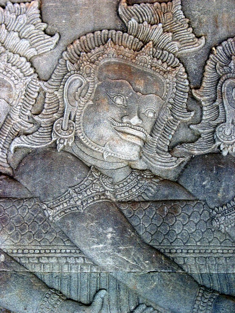
An asura grips the serpent in the Churning of the Sea of Milk relief on Angkor Wat's east gallery in Michael Gunther's August 2014 detail. Repeated hands and adjoining figures continue beyond the crop, reminding viewers that this close image is one fragment of a narrative read through movement along the wall. Michael Gunther, Asura in the Churning of the Sea of Milk relief; CC BY-SA 4.0. JPEG prepared; no crop or retouch.
Carved surfaces once interacted with colour, gilding, shadow and moving worshippers. Their present pale appearance is not a complete record of initial visual conditions. Nor is every repaired outline untouched twelfth-century work. [11] [12]
The Churning gallery's conservation illustrates architectural interdependence. Roof repair, drainage, stone consolidation, cleaning and documentation protect the narrative wall. Treating relief alone would leave the source of deterioration unresolved. [11]
Devatas, thresholds and repeated craft
Hundreds of standing female figures commonly described as devatas or apsaras occupy walls, pilasters and recesses. They vary in jewellery, hairstyles, gesture and dress, so repetition does not imply mechanical sameness. Their placement brings ideal courtly presence into passages between open courts and restricted sacred rooms. [12] [15]
The figures are carved shallowly enough to remain part of the wall, but projected ornaments catch light and human contact. Darkened or polished areas can record centuries of touch as well as modern crowd pressure. Conservation must distinguish stable patina from damaging deposits, and it must avoid cleaning every carving into artificial uniformity. [12]
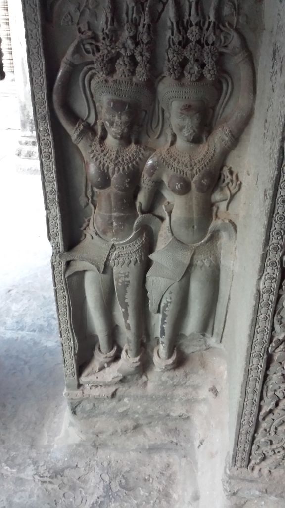
Two female celestial figures occupy a narrow wall panel in Yjfstorehouse's December 2015 photograph. Different headdresses, jewellery, poses and dress show individual decisions within a repeated workshop type; abrasion and darkened areas are visible but their causes are not assigned without material evidence. Yjfstorehouse, Pair of female celestial figures at Angkor Wat; CC BY-SA 4.0. JPEG prepared; no crop or retouch.
Door frames and lintels concentrate further work. Floral scrolls, divine scenes and guardian forms mark a change in access, while inscriptions can record later Buddhist devotion. A threshold is therefore a structural opening, an iconographic boundary and an archive of continued use.
Small library buildings stand symmetrically within the precinct even though their precise original functions remain debated. Their name is conventional, not proof that they stored manuscripts. They help articulate open ground and crossing routes while warning against turning familiar labels into certainty. [9] [15]
These repeated elements reveal workshop organisation. Templates and shared proportions supported continuity, yet individual carvers made local decisions around stone quality and position. Close viewing recovers human variation inside the larger royal system.
Angkor Wat within Greater Angkor
The World Heritage property covers about 400 square kilometres and includes numerous temples, ancient urban plans, roads and hydraulic structures. Angkor Wat is its most famous building, not a synonym for the entire property. [1]
Research using excavation, aerial survey and remote sensing has revealed occupation mounds, field systems and infrastructure across a much larger urban region. Stone temples survive conspicuously because secular palaces and houses were commonly constructed from perishable materials. Monumental visibility can distort what counted as the city. [16]
Reservoirs, embankments and canals stored, redirected and drained seasonal water. Their roles varied over time and should not be reduced to one perfectly controlled irrigation machine. They supported settlement and agriculture while managing a landscape exposed to monsoon extremes. [1] [14]
Angkor Wat's moat belongs to this broader hydrological world. Its stability is connected to groundwater, rainfall and neighbouring land use. Modern rehabilitation of ancient channels may support conservation, but it must account for current communities and ecology. [5]
Living religious continuity
The shift from a Vishnu-focused royal temple to Buddhist use was gradual rather than a single conversion date. Monastic and devotional occupation helped keep the monument meaningful after royal capitals moved. Buddhist images and practices are therefore part of its history, not contamination of a pure Hindu ruin. [6] [15]
Villages throughout Angkor Archaeological Park remain home to people who farm, worship and maintain ancestral connections. UNESCO identifies Angkor as living heritage and links tangible monuments to music, dance, ritual and local knowledge. [1]
Management decisions can affect housing, access and livelihoods. Zoning protects archaeological deposits and views, but conservation benefits cannot justify treating residents as visual obstructions. Current assessments must include rights, consultation and fair distribution of tourism income. [5] [17]
Visitors also enter a sacred place. Routes and barriers protect stone, while codes of behaviour recognise active worship. The same gallery can be archaeological evidence, national monument, workplace and devotional setting.
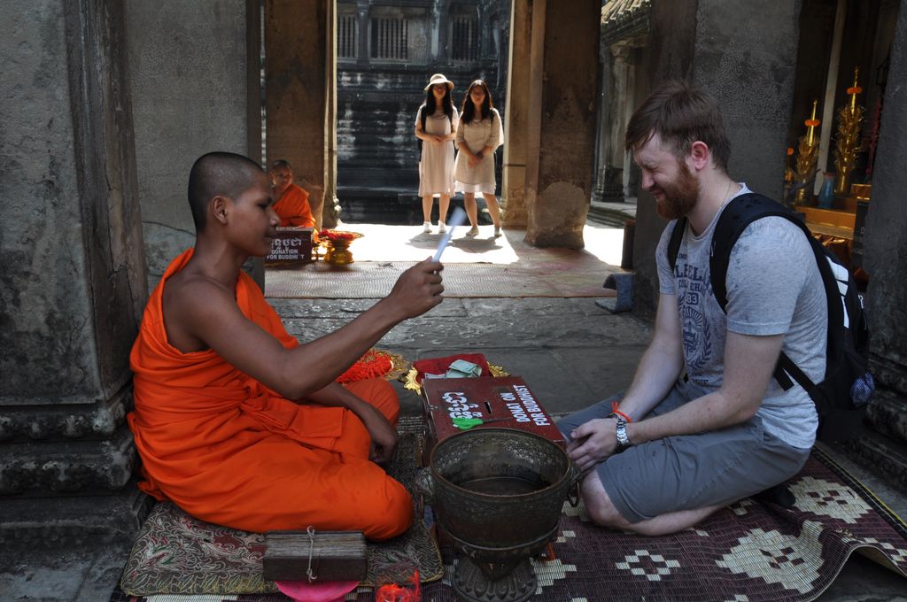
A Cambodian monk ties a blessing thread for a kneeling visitor within a stone bay at Angkor Wat in Antonio Kless's September 2018 photograph. Ritual objects, another monk and passing visitors document one contemporary encounter within a sacred place whose religious life continued after the Khmer court changed. Antonio Kless, Buddhist monk blessing a visitor at Angkor Wat; CC BY-SA 4.0. JPEG prepared; no crop or retouch.
Survey, colonial intervention and conservation
French scholars and conservators produced extensive plans, photographs and descriptions from the early twentieth century. These records are valuable, but the language of European discovery can erase Cambodian continuity. Nineteenth-century photographs also framed Angkor as an exotic ruin for distant audiences. [9] [18]
The École française d'Extrême-Orient used anastylosis and other methods to stabilise monuments. Anastylosis reassembles displaced original blocks where their positions can be established, adding new support only as needed. Even careful reassembly is an intervention that should remain documented. [10]
Civil conflict interrupted work and contributed to looting and institutional loss. When Angkor was inscribed on the World Heritage List in 1992, it was simultaneously placed on the List in Danger. Required measures included protective law, boundaries, a staffed national authority and coordinated conservation. [1] [3]
Cambodia established the APSARA National Authority, while the ICC-Angkor created a forum for reviewing international projects. Angkor left the danger list in 2004 after substantial institutional progress. Removal recognised improved safeguarding; it did not certify that stone, water, tourism and development posed no further risks. [4] [7] [8]
Current work combines Cambodian leadership with international technical partnerships. Training and documentation matter as much as a single repaired wall because stewardship must persist after a project ends. [7] [12]
Pressure, access and future care
Tourism provides employment and public understanding, yet concentrated footfall wears thresholds and creates crowding on steep stairs. Route management can redistribute visitors, but it must not transfer harm to quieter monuments or communities. [1] [17]
Climate change increases uncertainty around intense rain, heat and biological growth. Roof and drainage maintenance protect carved galleries; landscape monitoring helps manage water levels. Archaeological deposits beyond temple walls may be vulnerable to new roads and construction. [5]
The 2025 World Heritage decision confirmed that outstanding value continued while calling for caution over zoning, development and relocation. Heritage impact assessment is necessary before changes, especially where living communities bear consequences. [5]
Authenticity at Angkor Wat does not mean rejecting all repair. Stabilised blocks, renewed drainage and recorded supports can preserve historic material. The critical questions are whether evidence guides intervention, new work remains accountable and religious life continues with dignity. [1] [12]
Watch: Angkor Wat, Stone, Route and Architectural Evidence
Begin with Angkor Wat’s stone construction and durability, then widen the view to route, enclosure and architectural elements while keeping Khmer history, living worship, landscape and conservation visible.
How Is Angkor Wat Still Standing Today?
A concise structural account focuses on how Angkor Wat's sandstone blocks, joints and foundations were assembled. The article adds moat, route, relief, living worship, Greater Angkor and conservation context.
Watch on YouTubeWhy Angkor Wat matters
Angkor Wat coordinates distance and detail. The moat establishes territory; the causeway directs approach; galleries wrap narrative around the sanctuary; terraces convert hierarchy into ascent; towers make a cosmic and royal centre visible across the plain.
Its architecture also reveals the limits of monument-only history. Stone depended on perishable settlements, court labour, agriculture and water networks. Worship continued through political change, while modern conservation depends on Cambodian institutions and inhabited landscapes. [1] [16]
Reading the temple responsibly means holding these scales together. It is a masterpiece of Khmer design and carving, a continuing Buddhist place, one component of Greater Angkor, and fabric altered by centuries of care. None of those truths needs to cancel another.
Angkor Wat: Five Evidence Tests
Begin with a dated royal temple inside Greater Angkor, then connect approach, construction, carving, living worship and conservation before reducing the monument to one tower silhouette or a single cosmological explanation.
| Evidence | What it can establish | What else to verify |
|---|---|---|
| Commission and orientation | Inscriptions, reliefs and fabric connect Suryavarman II, Vishnu and a west-facing royal temple. | Keep funerary, devotional and political readings open where the evidence does not resolve one explanation. |
| Route and geometry | Moat, causeway, galleries, terraces and tower quincunx organise distance, hierarchy and ascent. | A schematic or cosmological analogy is not a measured reconstruction of every historic use. |
| Material and labour | Sandstone surfaces, laterite and earth cores, corbelled roofs and joints reveal connected building systems. | Name quarrying, transport, carving, drainage and maintenance rather than attributing the monument to a single designer. |
| Image and sacred life | Reliefs, devatas, thresholds and later Buddhist shrines record narrative and continued devotion. | Distinguish original fabric, later additions, touch, weathering, cleaning and repair. |
| Landscape and stewardship | Hydraulic networks, settlement archaeology, community knowledge and conservation records place the temple within living Angkor. | Test visitor access and development against resident rights, water, archaeology and long-term care. |
Frequently Asked Questions
Khmer king Suryavarman II commissioned it in the early twelfth century. Large teams of planners, quarry workers, transporters, masons and sculptors realised the temple, although most names are not recorded. [2] [13]
It was primarily dedicated to the Hindu god Vishnu and associated with Suryavarman II. It later became, and remains, an important Buddhist sacred place. [6] [15]
Its principal approach is unusually western. Scholars relate this to Vishnu, funerary meaning and relief direction, but no single explanation is universally sufficient. [6] [15]
They form a quincunx and are commonly read as the peaks of Mount Meru. The surrounding terraces and moat participate in a broader temple-mountain cosmology. [13] [14]
No. Cambodian communities and Buddhist worshippers maintained knowledge and use. European documentation expanded international attention but did not discover an unknown place. [1] [18]
Discussion
Which part of Angkor Wat best shows why route, structure, carving, sacred use and later care must be read together?
Reader Insights
Is the claim supported by standing fabric, inscription, relief, archaeological survey, material analysis, community knowledge or conservation documentation?
How do Suryavarman II, Khmer planners, quarry workers, transporters, masons, carvers, worshippers, residents and conservators occupy different parts of the record?
What changes when the tower silhouette is tested against the moat, causeway, hidden cores, settlement landscape, living devotion, climate and visitor pressure?
Join the Conversation
Share a documented observation below, naming the place, date or campaign, people, route, material or sacred evidence, condition and later intervention.
References
- UNESCO World Heritage Centre, “Angkor.” View source
- ICOMOS, “Angkor advisory body evaluation.” View source
- UNESCO World Heritage Centre, “Decision 17 BUR VIII.2.” View source
- UNESCO World Heritage Centre, “Removal of Angkor from the List of World Heritage in Danger.” View source
- UNESCO World Heritage Centre, “Decision 47 COM 7B.63.” View source
- APSARA National Authority, “Angkor Wat Temple.” View source
- APSARA National Authority, “APSARA National Authority.” View source
- ICC-Angkor, “International coordination at Angkor.” View source
- École française d'Extrême-Orient, “Angkor Vat architectural survey.” View source
- École française d'Extrême-Orient, “Conservation at Angkor.” View source
- World Monuments Fund, “Churning of the Sea of Milk Gallery.” View source
- German Apsara Conservation Project, “Angkor Wat conservation.” View source
- Metropolitan Museum of Art, “Southeast Asia, 1000–1400.” View source
- Metropolitan Museum of Art, “The Art of South and Southeast Asia: A Resource for Educators.” View source
- Smarthistory, “Angkor Wat.” View source
- Greater Angkor Project, “Greater Angkor urban landscape.” View source
- UNESCO and APSARA, “Angkor Tourism Management Plan.” View source
- Metropolitan Museum of Art, “Emile Gsell view of Angkor Wat.” View source