


 by Tom Gurney
Tom Gurney BSc (Hons) is an art history expert with over 20 years experience
Email: tomgurney1@gmail.com / Phone: +44 7429 011000
From Footprint to Experience: Reading Cathedral Plans Without Losing Their History
A cathedral floor plan is a horizontal drawing of the building, or sometimes its wider precinct, at a stated level. It can locate walls, supports, openings and named spaces, but its meaning depends on the document's purpose. Measured surveys, phased drawings, visitor guides, conjectural reconstructions and teaching schematics can all appear plan-like while answering different questions.
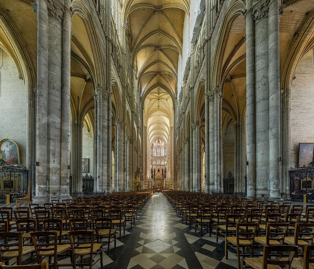
The nave of Amiens Cathedral looking toward the choir, April 2015. DAVID ILIFF, Amiens Cathedral Nave 1, Picardy, France; CC BY-SA 3.0. JPEG prepared; no crop or retouch. Licence URL: https://creativecommons.org/licenses/by-sa/3.0.
Start with the title block, date, represented level, north arrow, scale and key. Only then follow the route from entrances through the nave and crossing towards the choir, chapels and other spaces. A plan can clarify movement and adjacency; it cannot independently reveal height, light, acoustics, materials above the cut plane or the complete construction history. [1] [2] [3]
Contents
Cathedral does not describe a plan shape
A cathedral is defined by institutional role. In the Church of England glossary it is the principal church of a diocese, staffed by a dean or provost and chapter, where the diocesan bishop has a cathedra, or seat. A footprint cannot prove that status. A vast cruciform Gothic church might instead be an abbey or parish church, while a cathedral may occupy a smaller or much-altered building. [4]
This matters when comparing drawings. The word “cathedral” explains governance and use, not a universal arrangement of nave, transepts and apse. Period, region, denomination, site, patronage and successive building campaigns account for the differences that plans record.
Six kinds of floor-plan evidence
The first question is not “Where is the transept?” but “What am I looking at?”
- A measured survey is a dimensionally controlled record of stated existing conditions or other specified features. Under the National Park Service documentation standard, measured drawings are one part of a record that also includes photographs and written history. [2]
- A record drawing describes observed fabric and may include measurements, notes and analytical interpretation. Historic England distinguishes this kind of building understanding from a metric geospatial survey. [1]
- A reconstruction proposes an earlier, incomplete or lost state. Its date, evidence and conjectural portions must be declared; clean lines do not turn an interpretation into observed fact.
- A phase plan separates construction, alteration and demolition campaigns. Colours need patterned or written equivalents, and the key must give dates or defensible ranges.
- A visitor map prioritises destinations, routes, entrances and current facilities. It can be excellent evidence for access while simplifying bay spacing or omitting features that visitors do not need.
- A teaching schematic isolates selected relationships. It should say that it is not measured and should never inherit a scale bar from its source material.
The HABS drawing guidance treats field measurement, line weights, plans, sections, interpretive drawings, scales, dimensions, labels and title blocks as distinct stages or conventions. A professionally drawn sheet is therefore not self-explanatory: the information around the plan establishes how it can be used. [3]
Read the key before the cathedral
In a conventional architectural plan, a horizontal plane passes through the building. Fabric cut by that plane is usually drawn more strongly than surfaces or edges seen beyond it. Piers, columns, wall openings, doors and stairs indicate how bays connect. Lighter, broken or patterned lines may mark something above, below, removed, conjectured or belonging to another phase.
None of those line meanings is universal. A broken outline could be a vault overhead on one sheet and an excavated foundation on another. A coloured wall might be thirteenth-century fabric, modern repair or simply a visitor zone. The legend decides.
Scale also needs care. A ratio or scale bar permits measurement only when the source and reproduction preserve it. A screenshot enlarged to fit a page may retain the printed words “1:200” without remaining 1:200 on screen. North must likewise come from a documented arrow or site record. “Liturgical east” often means the altarward direction and is not proof of geographic east.
Locate relationships, not just names
Many Western cathedral plans can be approached as a connected sequence. A principal or west entrance opens into the nave. One or more aisles flank it, their supports appearing as rows of columns or piers. A transept may cross this longitudinal body, producing a crossing. Beyond or around that junction lie spaces labelled choir, quire, chancel, presbytery or sanctuary according to the building and source. An apse may terminate the route, and an ambulatory may continue around it to chapels. [5]
Those labels are orientation points, not a complete glossary. The dedicated church-parts page explains their definitions and overlap. Here, the useful questions are relational: Does the aisle continue past the transept? Is the choir east or west of the crossing? Can someone reach a chapel without entering the choir enclosure? Does a stair descend to a crypt or rise to another level? Does the cloister connect to the church, or does a baptistery stand apart?
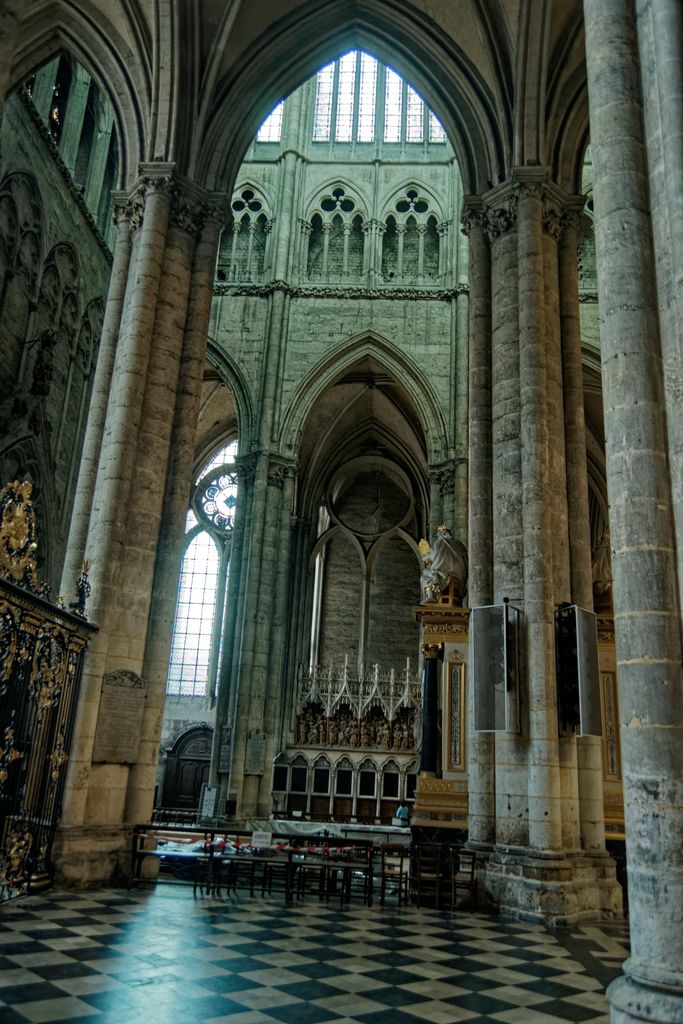
Amiens Cathedral, looking from beside the choir toward the south transept, May 2010. Txllxt TxllxT, Amiens: beside the choir toward the south transept; CC BY-SA 4.0. JPEG prepared; no crop or retouch.
A floor plan can answer those questions when its level and date are known. It does not show the full height of a nave, the window sequence of a clerestory or the profile of a vault. Pier positions may suggest a bay rhythm, but they do not establish concealed foundations, present structural condition or an engineering load path.
Movement and present access
Architecture is occupied over time. In medieval churches, aisles and ambulatories could enable movement towards shrines and chapels without interrupting services in the central liturgical zones. Screens, gates, stalls, tombs and altars then directed who could see or enter particular areas. [5]
Present visitor plans map a different layer. Durham Cathedral's official map labels the nave, quire, shrine of St Cuthbert, Chapel of the Nine Altars, Galilee Chapel, cloister and chapter house, as well as entrances, ramps, lifts and facilities. These labels make it useful for navigating the building now. They do not turn its simplified geometry into a medieval measured survey. [10]
The cathedral's account of the quire supplies evidence that the map alone cannot: the space lies beyond the crossing and contains the choir stalls, organ, bishop's cathedra and high altar. It also records the screened use of the area by the medieval monastic community and subsequent changes. Walls, furnishings and patterns of access can therefore belong to different dates. [11]
Construction history needs a phase plan
Cathedrals commonly incorporate long sequences of work. Foundations can survive beneath rebuilt walls; a choir may precede a nave; perimeter chapels may fill spaces between buttresses; towers can replace earlier terminations; a cloister range may be altered independently. A single undifferentiated outline disguises those relationships.
Historic England's recording guidance combines visual survey, photography, documentary work and interpretation of fabric. It separates phasing analysis from precise metric survey while treating them as complementary. A reliable account may need both: measurement supplies spatial control, and investigation explains joints, blocked openings, material changes and documentary dates. [1]
A phase plan should distinguish observation from interpretation. “Wall A abuts Wall B” is physical evidence; “Wall A belongs to the campaign of 1250” requires a dated argument. If excavation reveals a former apse below the present choir, the lower feature should be drawn on its own level or clearly patterned—not merged with the standing ground floor as though both were visible together.
Amiens: coherent design with later additions
The Mapping Gothic France project provides an academic record for Amiens Cathedral with a floor plan, historical plans, panoramas and bibliography. Its value lies partly in connecting representations: the plan can be tested against the building's volumes and scholarly record rather than viewed in isolation. [6]
Smarthistory describes a west entrance leading into a tall central nave flanked by narrower aisles. A transept intersects the longitudinal body and defines the choir, producing a Latin-cross relationship in plan. Its account of arcade, triforium and clerestory belongs to the elevation, reminding us that the familiar three-storey interior cannot be read from footprint alone. [7]
UNESCO describes the nave and choir as balanced on either side of the transept and dates the principal campaign from 1220 to 1288. Yet it also records chapels inserted between the nave-aisle buttresses between 1292 and 1375. Amiens can therefore be both unusually coherent in conception and historically layered. An interpretive plan should hatch those later perimeter additions instead of implying that every present chapel belongs to 1220. [8]
The lesson is not that Amiens supplies the ideal cathedral. It shows how an axial route, transept hinge and surrounding chapels can be read while retaining dates for fabric that modifies the principal design.
Toledo: breadth and a choir west of the crossing
Toledo Cathedral overturns a common labelling shortcut. Its Gothic plan has a broad body with double aisles, short transept projections, an ambulatory and a continuous ring of radiating chapels. Smarthistory connects the breadth and the cloister's position to the footprint of the former Friday mosque on the site, while also documenting more than a century of Gothic construction and later changes. That relationship should be presented as a historical interpretation, not a rule for every Iberian cathedral. [9]
Most importantly for plan reading, Toledo's enclosed choir stands in the nave west of the crossing. The principal chapel, or capilla mayor, and high altar occupy the apse region. A reader who automatically writes “choir” on the arm beyond the transept would therefore misread the building.
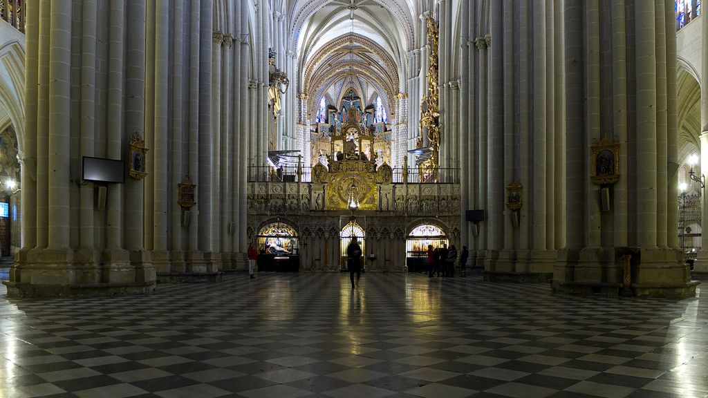
Toledo Cathedral, looking through the nave toward the back of the choir enclosure, December 2012. José Luis Filpo Cabana, Toledo Cathedral: nave toward the back of the choir enclosure; CC BY 3.0. JPEG prepared; no crop or retouch.
The useful comparison with Amiens is precise. Both plans have Gothic aisles, transepts and eastern chapels, but the position and enclosure of the choir alter movement and sightlines. Regional difference is not merely a different outer silhouette; it can reside inside an apparently familiar footprint. [9]
Canterbury: one complex, several levels
Canterbury Cathedral's accessibility plan is organised around routes. It maps the nave, south-west transept, Martyrdom, quire, Trinity Chapel, crypt, Great Cloister and chapter house, then identifies barriers, lifts, ramps, stairs and exterior alternatives. Because it was made for visitors with disabilities, those details are central rather than incidental. [12]
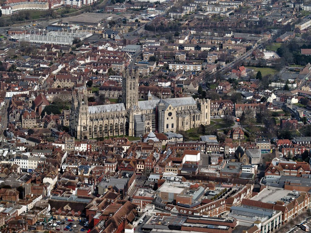
Canterbury Cathedral and surrounding city from the air, April 2013. John Fielding, Canterbury Cathedral aerial view; CC BY 2.0. JPEG prepared; no crop or retouch. Original Flickr photograph.
Its limitations are equally informative. The plan cannot place all named destinations on one physical plane without qualification. The cathedral's education resource states that the crypt lies beneath the quire and Trinity Chapel. It records the rebuilding of the quire after the fire of 1174 and identifies Trinity Chapel's purpose as housing Thomas Becket's shrine. It also explains how the Great Cloister linked the former monastery and its chapter house. [13]
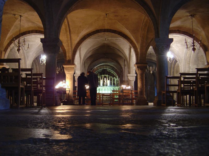
The crypt beneath Canterbury Cathedral, October 2003. Saxon Moseley, Canterbury Cathedral crypt; CC BY 2.0. JPEG prepared; no crop or retouch. Original Flickr photograph.
Canterbury therefore calls for at least two diagrams: a ground or visitor relationship and a separate below-level crypt strip. The 1174 rebuilding and later access equipment need distinct phase or status symbols. Flattening them into a clean outline would make the drawing easier to glance at but harder to trust.
Pisa: when the site plan matters
At Pisa, the cathedral is only one of four major precinct buildings. UNESCO identifies the cathedral, baptistery, campanile and cemetery as distinct monuments developed in close proximity from the eleventh to the fourteenth century. Their spatial grouping is an essential part of the Piazza del Duomo. [14]
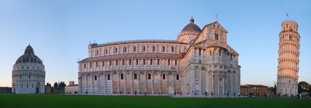
The baptistery, cathedral and campanile at Pisa, October 2024. kallerna, Pisa: baptistery, cathedral and campanile across the precinct; CC BY-SA 4.0. JPEG prepared; no crop or retouch.
Smarthistory narrows the reading inside the cathedral. The main body is basilican and double-aisled. Each transept arm repeats an aisled arrangement ending in a smaller apse, creating a strongly four-armed relationship, while a dome rises over the crossing. The freestanding baptistery and campanile are not rooms omitted from the church plan; they are separate buildings. [15]
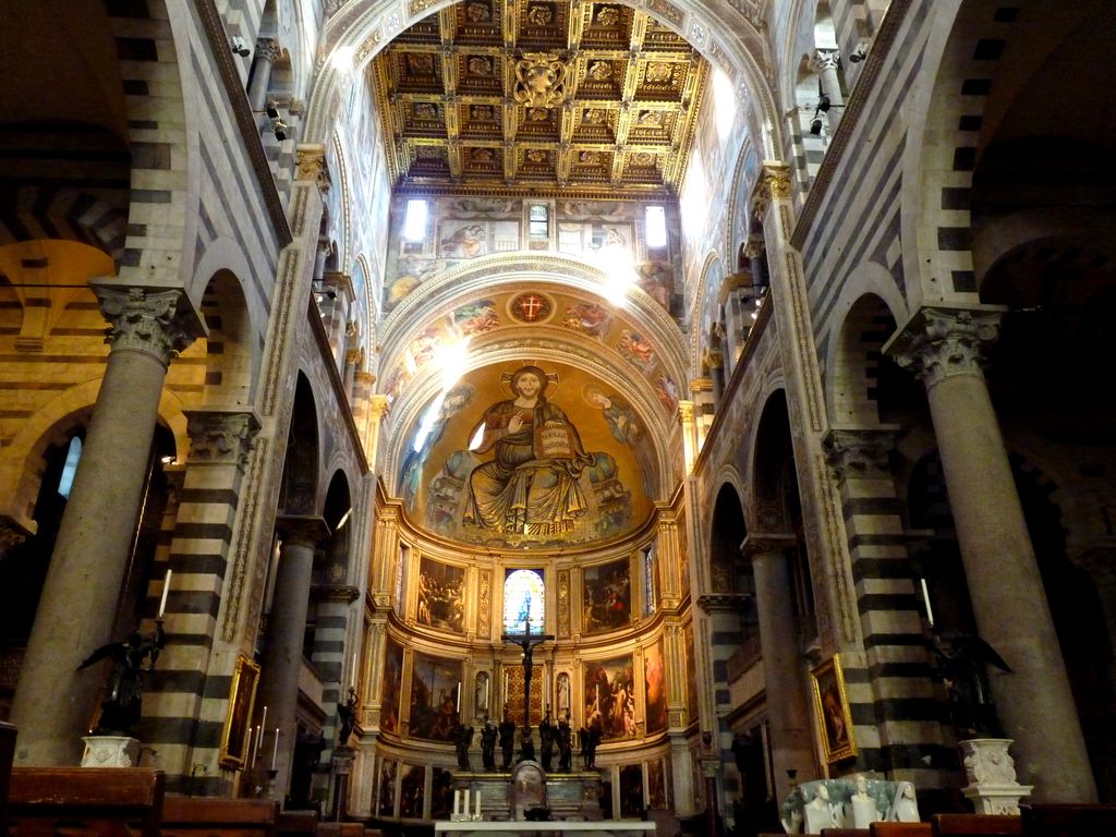
Inside Pisa Cathedral, looking toward the main apse, October 2010. Dudva, Pisa Cathedral: interior toward the main apse; CC BY-SA 3.0. JPEG prepared; no crop or retouch.
A site plan and a floor plan answer different questions here. The first locates baptism, bells, worship and burial across the precinct. The second explains the cathedral's nave, aisles, apses and crossing. Combining the two scales without a key would conceal the very arrangement that makes Pisa useful for comparison.
A method for comparing cathedral plans
Use the same sequence for every drawing:
- Record the source, maker, date, drawing type, level, scale and orientation.
- Read the legend and identify observed, conjectured, later, removed, above- and below-level fabric.
- Trace the wall envelope, supports, openings and stairs before assigning room names.
- Mark the main route, lateral alternatives, barriers and connections to chapels or precinct buildings.
- Separate masonry from furniture and current access equipment.
- Test the plan against sections, elevations, photographs, documentary history and the standing fabric.
- Compare one defined relationship at a time: choir position, aisle continuity, eastern circulation, vertical layering or precinct distribution.
This prevents a comparison from becoming a beauty contest or a typological ladder. Amiens answers a question about axial integration and later chapels; Toledo tests choir position; Canterbury exposes levels and phases; Pisa expands the frame to a precinct.
Watch: From Cathedral Plan to Built Experience
Choose a concise guide to the height, supports and light omitted by a floor plan, or follow the longer building history of Chartres Cathedral.
Gothic Architecture Explained
A concise examination inside Beverley Minster connecting pointed arches and rib vaults to supports, openings and the experience of a Gothic interior.
Watch on YouTubeReading the diagram
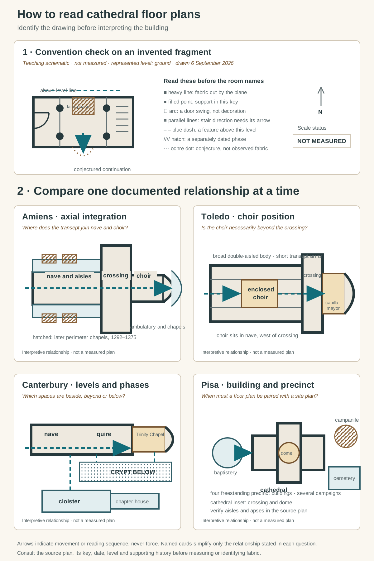
Original relationship schematics, not measured plans and not to scale. The convention fragment is invented; the four named cards isolate source-backed relationships without reproducing any source outline, coordinates or route styling.
Text alternative for the diagram
The first panel is an invented plan fragment showing a heavy cut wall, four supports, a door swing, a stair, light visible edges, a hatched later phase, dashed above-level fabric and dotted conjecture. Its title block says teaching schematic, not measured. Four lower cards follow. Amiens reads from west entry through nave and aisles to transept, choir and an ambulatory, with later perimeter chapels patterned separately. Toledo has a broad double-aisled body, short transepts and an enclosed choir west of the crossing, separate from the principal chapel at the apse. Canterbury pairs a ground-level route with a separate crypt-below band and an attached cloister and chapter house. Pisa places cathedral, baptistery, campanile and cemetery as separate precinct buildings, with a small inset for the cathedral's crossing and apsed transept arms. Arrows show movement or reading sequence, never structural force.
The diagram below is a set of original relationship schematics, not copied or measured cathedral plans. Its first panel explains conventions on an invented fragment: heavier cut walls, supports, a door swing, stairs and keyed patterns for other levels, phases and conjecture. The north arrow belongs only to that invented drawing, and the scale field reads “not measured.”
Four comparison cards then isolate the evidence above. Amiens links west entry, nave and aisles, transept, choir and ambulatory while hatching later perimeter chapels. Toledo places an enclosed choir within the broad nave west of the crossing. Canterbury separates its crypt-below strip from the ground-level route and attaches cloister and chapter house. Pisa uses precinct masses for cathedral, baptistery, campanile and cemetery, with a small cathedral inset.
Arrows describe movement or reading sequence, never structural force. Matching colours do not imply identical date or function, because every state is repeated through labels, patterns or line styles. Each card names its question and its status as an interpretive relationship rather than a measured plan.
Cathedral Plans: Five Evidence Tests
Read the drawing type and stated level before comparing spatial relationships.
| Evidence | What it can establish | What else to verify |
|---|---|---|
| Measured survey | Controlled dimensions and observed fabric at the stated level. | Survey date, scale integrity and features concealed from measurement. |
| Phase plan | Relationships between dated building campaigns, removals and additions. | Which dates are observed, documented, inferred or conjectural. |
| Visitor map | Current routes, destinations, entrances, barriers and facilities. | Geometric simplification and changes since publication. |
| Teaching schematic | Selected spatial patterns and comparative relationships. | No measurement or universality unless independently documented. |
| Site or precinct plan | Separate buildings, open spaces and connections beyond the cathedral walls. | Different drawing scale, levels, ownership and present access. |
Frequently Asked Questions
It can show the footprint at a stated level, including walls, supports, openings, stairs, spaces and connections. Depending on its purpose, it may also show dimensions, phases, conjecture, current visitor routes or adjacent buildings. The key and title block determine which claims it supports.
No. Cathedral status is institutional, and cathedral buildings include longitudinal, cruciform, hall, centralised and adapted plans. Even two cross-shaped cathedrals may place the choir, chapels and precinct buildings differently. [4]
Only if the drawing is a controlled measured survey, its scale or dimensions are supplied, and the reproduction preserves that scale. A visitor map or teaching diagram can locate parts without supporting exact measurement. [2] [3]
They may represent different levels, construction phases, reconstructions or present conditions. Cathedrals change through rebuilding, new chapels, removed screens, archaeological discovery and revised access. Compare the date, key and purpose before treating two outlines as contradictory.
Discussion
Which cathedral plan best demonstrates why drawing type, level and building history must be read together?
Reader Insights
Is the source a measured survey, phase plan, visitor map, reconstruction or teaching schematic?
Which relationships are on the represented level, above it, below it or elsewhere in the precinct?
Which features belong to later campaigns, furnishings or present visitor use?
Join the Conversation
Share a documented cathedral plan below, noting its maker, date, purpose, level, scale and the relationship it helps you interpret.
References
- Historic England. Understanding Historic Buildings: A Guide to Good Recording Practice. View source
- National Park Service. “Secretary of the Interior's Standards and Guidelines for Architectural and Engineering Documentation.” View source
- National Park Service. HABS Guidelines: Recording Historic Structures and Sites with HABS Measured Drawings. View source
- Church of England. “Glossary.” View source
- Smarthistory. “Medieval churches: sources and forms.” View source
- Mapping Gothic France, Columbia University Media Center for Art History. “Amiens, Cathédrale Notre-Dame.” View source
- Smarthistory. “Amiens Cathedral.” View source
- UNESCO World Heritage Centre. “Amiens Cathedral.” View source
- Smarthistory. “Spanish Gothic cathedrals, an introduction.” View source
- Durham Cathedral. Welcome to Durham Cathedral — Cathedral Map. View source
- Durham Cathedral. “The Quire.” View source
- Canterbury Cathedral. Facilities for Visitors with Disabilities — Cathedral Plan. View source
- Canterbury Cathedral Learning. “The Cathedral.” View source
- UNESCO World Heritage Centre. “Piazza del Duomo, Pisa.” View source
- Smarthistory. “The Romanesque churches of Tuscany: San Miniato in Florence and Pisa Cathedral.” View source