


 by Tom Gurney
Tom Gurney BSc (Hons) is an art history expert with over 20 years experience
Email: tomgurney1@gmail.com / Phone: +44 7429 011000
Beyond the Gilded Roofline: Reading Thai Architecture through Regions, Institutions and Change
Thai architecture is not one gilded roof profile repeated across a timeless kingdom. It includes prehistoric settlements, moated Dvaravati towns, Buddhist monasteries, royal compounds, timber houses, market streets, city walls, canals, railway stations, concrete civic buildings and contemporary housing. Northern Lanna, central plains, northeastern plateau and southern peninsula settings developed through distinct political, religious, climatic and commercial histories.
Monumental temples dominate surviving evidence because brick and stone outlast timber, thatch and earth. Their prominent towers and rooflines are only parts of larger institutions with halls, libraries, residences, kitchens, ponds, walls and routes. Architectural history needs those programmes as well as visible form.
Getty vocabularies can coordinate English names for places, rulers, periods and objects, but terms such as “Thai,” “Siamese,” “Lanna” and “Dvaravati” have different historical boundaries [1]. A controlled name should never turn modern borders into an origin story.
Contents
Settlement history precedes named kingdoms
Ban Chiang in northeastern Thailand preserves a prehistoric settlement mound and burials associated with farming, ceramics and metalworking from the second millennium BCE onward [2]. The architecture itself survives mainly through excavated soil, postholes and occupation surfaces rather than standing houses.
These traces show households within a changing agricultural community. Reconstructions can make roof span and enclosure plausible, but they cannot supply a complete elevation without evidence. Material from graves also reveals craft and exchange rather than a direct blueprint for later buildings.
Dvaravati was regionally varied
Si Thep preserves a moated ancient town, nearby monuments and evidence linked to Dvaravati culture from roughly the sixth to tenth centuries, followed by Khmer connections [3]. Brick, laterite, stucco, sculpture and waterworks show an urban religious centre located on inland routes.
At Phu Phrabat, natural rock shelters and a landscape of boundary stones were adapted for Buddhist practice during the Dvaravati period [4]. This is architecture made by marking, approaching and inhabiting landforms, not only by raising freestanding masonry.
Sukhothai joined three towns and their infrastructure
The World Heritage property combines Sukhothai, Si Satchanalai and Kamphaeng Phet. They served political, religious, ceramic-production and defensive roles within a connected thirteenth- to fifteenth-century kingdom. Roads, moats, reservoirs, canals and earthworks bind their monuments into territorial systems [5].
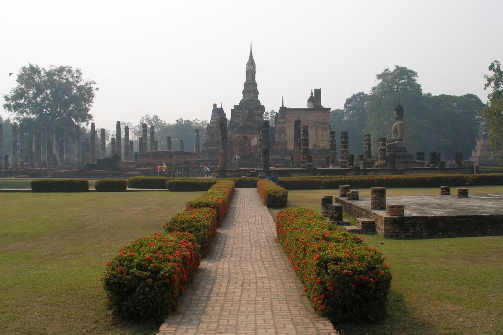
Wat Mahathat at Sukhothai, photographed by Vyacheslav Argenberg in February 2007. Brick monuments, paths and open ground belong to a wider three-town system of roads, moats, reservoirs, kilns and settlement evidence. Vyacheslav Argenberg, Wat Mahathat, Sukhothai; CC BY 4.0. JPEG prepared; no crop or retouch.
Brick monasteries with stucco surfaces are the most visible buildings, but excavation also records workshops and ordinary occupation. The label “Sukhothai style” helps group dated artistic evidence; it does not mean that every structure in the kingdom looked alike.
Smarthistory's Sukhothai survey connects monuments and sculpture with the kingdom's Theravada Buddhist patronage while also acknowledging regional precedents [15]. Such synthesis is valuable when used beside archaeology: formal comparison can identify related workshops, but it cannot by itself date an occupation layer or determine how a court financed construction.
Water served several purposes
Dams, ponds and canals supported household supply, cultivation, ritual, transport and defence. Some features remain in local use. Their construction displays technical knowledge without proving that royal control operated identically across the landscape.
Ceramic kilns at Si Satchanalai connect architecture to fuel, clay, labour and export. Buildings depended on these material economies: roof tile and decorative finish came from production landscapes that are easy to omit from monument surveys.
A wat is an institution, not one building
In everyday English, “temple” can conceal several components. A wat may include an ordination hall, image or assembly hall, stupa or chedi, scripture library, bell structure, monks' residences, kitchens, cremation facilities, walls and open courts. Names and arrangements vary by period and regional tradition.
The ordination hall has a particular monastic function and consecrated boundary. An image hall can host worship without serving ordination. A stupa enshrines relics or commemoration and is not an occupied hall. Programmes should be identified before visual comparison.
Buddhism changed across networks
Buddhist texts, monks, relic practices and images travelled through Sri Lanka, mainland Southeast Asia and maritime routes. Thai patrons and builders transformed them within local institutions. The Buddhist architecture guide holds the transregional history; this page follows specific building cultures in Thailand [16].
Sukhothai patronage helped establish forms of Theravada monastic life, while older Mahayana and Hindu evidence remained in the region. Religious change was neither instantaneous nor architecturally uniform.
Lanna centres the northern region
Chiang Mai was founded in 1296 as a capital of Lan Na. Its old city, monasteries, walls, moats and surrounding sacred landscape record northern political and religious institutions [7]. Timber halls, steep layered roofs and regional decorative practices developed under changing Burmese and Siamese relationships.
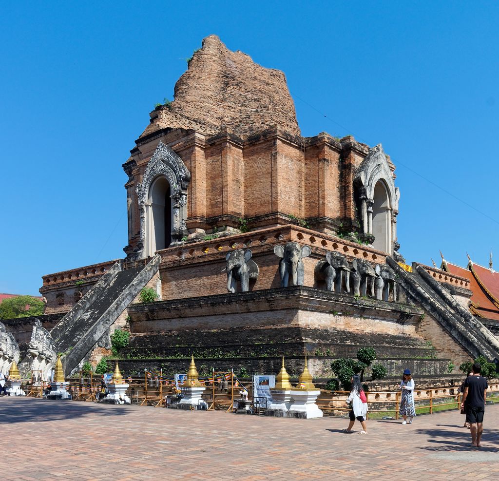
The partly ruined chedi of Wat Chedi Luang in Chiang Mai, photographed by Jakub Hałun in November 2017. Brick mass, sculpted stair, later repairs and present visitors record a northern institution shaped by damage and continuing use. Jakub Hałun, Wat Chedi Luang, Chiang Mai; CC BY-SA 4.0. JPEG prepared; no crop or retouch.
Lanna is not a provincial version of Bangkok. Northern builders worked with local timber resources, craft lineages and climatic demands. Monastic compounds and houses also changed through fire, warfare, rebuilding and modern tourism.
Roofs are material and maintenance systems
Timber trusses, posts and purlins carry tile, wooden shingle, thatch or metal roofs. Multiple roof tiers may express programme and status while managing spans and runoff. Finials are religious or royal markers in particular contexts, not interchangeable national decoration.
Deep eaves shade walls and openings. High roofs and vented gables can release heat, while raised floors protect domestic spaces from dampness and short floods. These responses vary with region, site and household resources.
Ayutthaya was a river metropolis
Ayutthaya became a Siamese capital around 1350 and developed on an island shaped by three rivers. Roads, canals and moats organised royal, monastic, commercial and residential zones while connecting the city to maritime trade [6]. It was an inhabited diplomatic and economic centre, not simply a field of temple ruins.
Foreign merchants, envoys and religious communities from China, Japan, Persia, South Asia and Europe maintained enclaves and institutions. Architectural exchange occurred through clients, craftspeople, materials and negotiated permission. A foreign-looking detail does not by itself establish who designed or used a building.
Destruction changed the evidence
Burmese forces sacked Ayutthaya in 1767. Fire and abandonment destroyed extensive timber urban fabric and damaged masonry. The court and many inhabitants moved; the old capital was not rebuilt in the same form.
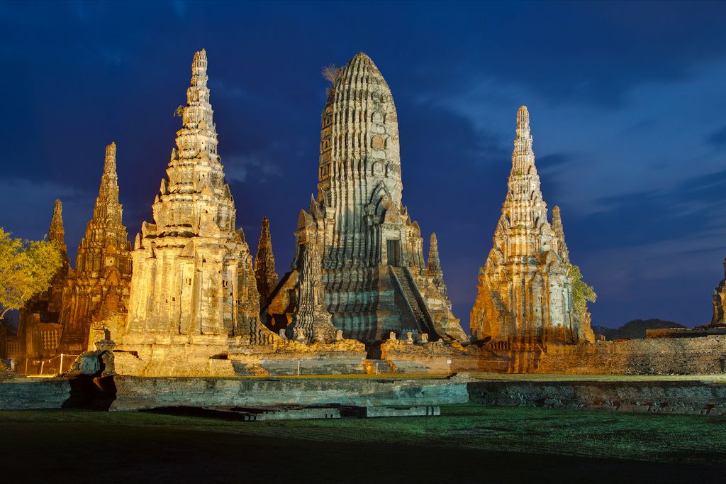
Wat Chai Watthanaram at Ayutthaya, photographed by JJ Harrison in April 2013. Illuminated prang and towers survive where fire, war and abandonment removed much of the river capital's timber urban fabric. JJ Harrison, Wat Chai Watthanaram, Ayutthaya; CC BY-SA 3.0. JPEG prepared; no crop or retouch.
Surviving prang, stupas, monastery walls and foundations are therefore an uneven sample. Historic maps, foreign accounts, excavation and mural painting help recover canals, palaces, houses and neighbourhoods. Each source has its own viewpoint and omissions.
Materials carried structure and meaning
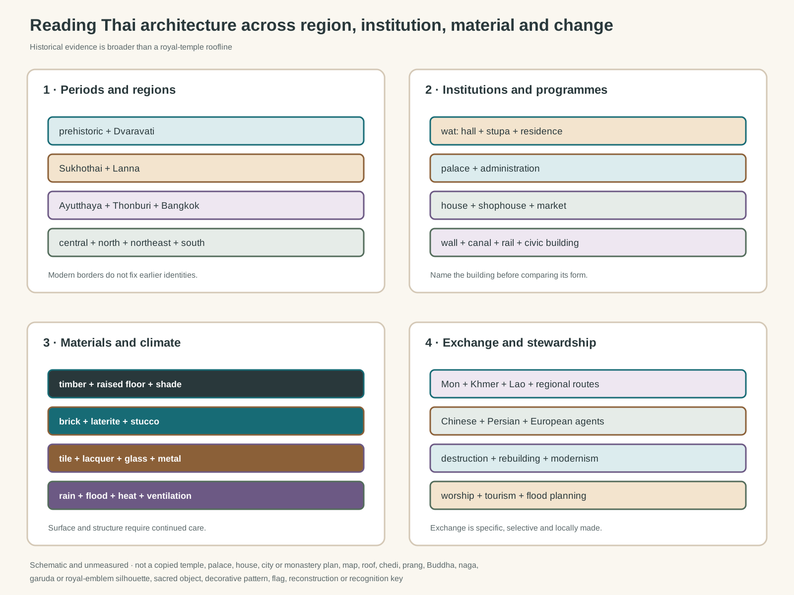
Original unmeasured evidence diagram. It is not a copied temple, palace, house, city or monastery plan; map; roof, chedi, prang, Buddha, naga, garuda or royal-emblem silhouette; sacred object; decorative pattern; flag; reconstruction; or visual identification key.
Text alternative for the diagram
The diagram separates prehistoric, Dvaravati, Sukhothai, Lanna, Ayutthaya, Bangkok and regional evidence; monastery, palace, house, market and infrastructure programmes; timber, brick, laterite, plaster, roof, ventilation and water systems; and exchange, destruction, urbanisation, tourism and stewardship.
Brick masonry formed walls, towers and vaults, often protected by stucco or plaster. Laterite served in foundations and walls where locally available. Timber enabled wide halls, verandas, partitions and replaceable roof structures. Ceramic tiles, lacquer, gilding, coloured glass and painted surfaces added weathering layers and institutional display.
Tropical exposure rapidly damages unprotected finishes. Bright restorations may reflect documented programmes, later periods or new devotional maintenance. Dating the surface matters as much as naming its colour.
Craft was organised knowledge
Carpenters, masons, plaster workers, tile makers, painters, lacquer specialists, metalworkers and sculptors collaborated. Royal or monastic patrons commissioned work, but workshops determined jointing, sequencing and repair. Material supply linked forests, clay pits, quarries and kilns to cities.
The Fine Arts Department protects and researches ancient monuments and national museums [9]. Its virtual museums and Bangkok collection connect architectural fragments with inscriptions, sculpture and everyday objects [10] [11]. Objects clarify building use only when provenance is retained.
Bangkok inherited and changed capital practices
After a short Thonburi period, Bangkok became the principal capital in 1782. Early Rattanakosin rulers drew on Ayutthaya court and urban precedents while creating new palace, monastery, wall and canal systems. Builders and materials moved from older centres, but the new river city developed its own institutions.
Canals supported transport, drainage, defence, markets and settlement. Roads, railways and later land filling altered that water-oriented fabric. The old Rattanakosin area now holds royal, religious, civic, commercial and residential layers managed amid a much larger metropolis [24].
Royal architecture is not the whole city
The Grand Palace and major monasteries dominate tourism imagery, yet Bangkok grew through merchant shophouses, floating and land markets, mosques, churches, Chinese shrines, workshops and workers' housing. These communities shaped materials and construction beyond court patronage.
Met chronologies locate Sukhothai, Ayutthaya and early Bangkok art within shifting regional and international relations [17] [18] [19]. Portable works show commissions and exchange but should not substitute for neighbourhood and infrastructure evidence.
Southern building followed maritime routes
Nakhon Si Thammarat was a long-standing southern centre connected to the Malay Peninsula, Sri Lanka and maritime trade. Wat Phra Mahathat Woramahawihan developed as a major Theravada Buddhist institution with a prominent stupa and active ritual landscape [8].
Southern timber houses respond to intense rain, humidity and ventilation needs, while Muslim communities built mosques using regional carpentry and later masonry. “Thai architecture” must leave room for Malay, Chinese and other community ownership within the country.
Northeastern domestic and religious building likewise reflects Lao relationships and plateau conditions. Regional exchange does not make these places less local; it explains how communities selected forms and skills.
Houses are adjustable environments
Historic timber houses commonly raise inhabited floors above ground on posts. The undercroft can support work, storage and airflow, while modular rooms and verandas allow households to expand or move components. Steep roofs and broad eaves shed monsoon rain.
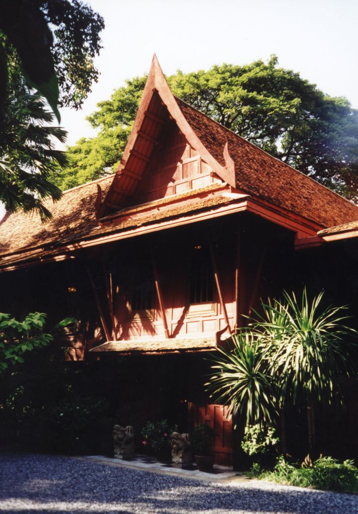
A collected timber house at the Jim Thompson museum in Bangkok, photographed by Ahoerstemeier in November 2000. Raised floor, deep eaves and adjustable enclosure show climatic strategies, while relocation and museum use complicate any vernacular label. Ahoerstemeier, Jim Thompson house; CC BY-SA 3.0. JPEG prepared; no crop or retouch.
There is no single Thai house plan. Central floodplain compounds, northern timber dwellings, northeastern houses and southern buildings respond differently to water, wind, kinship and livelihood. Thatch, tile and corrugated metal also indicate changing markets and maintenance capacity.
Everyday buildings change fastest
Families replace decayed posts, enclose verandas, add kitchens and install services. A house can retain spatial practices while losing early fabric, or preserve old timber after its use changes. Documentation should distinguish these continuities.
Household compounds also include detached cooking spaces, granaries, fences, wells and planted ground. Their relationships may reveal work and kinship more clearly than the principal house façade. Flood depth, boat access and the seasonal movement of animals or tools can change how an apparently open undercroft operates.
Urban shophouses answer another economy. Repeated narrow plots combine street trade, storage and residence, often with masonry party walls and timber floors. Renovation for cafés or hotels can retain a frontage while removing the ventilation, service routes and mixed use that made the type function.
Heritage tourism sometimes relocates houses into display compounds. This can save material and teach construction, but it removes the original settlement, work and neighbour relationships.
Nineteenth-century exchange was selective
Siam remained formally independent during European imperial expansion, but treaties and unequal power reshaped trade, taxation and territory. Courts commissioned embassies, ministries, barracks, schools and infrastructure using European-trained and locally trained specialists.
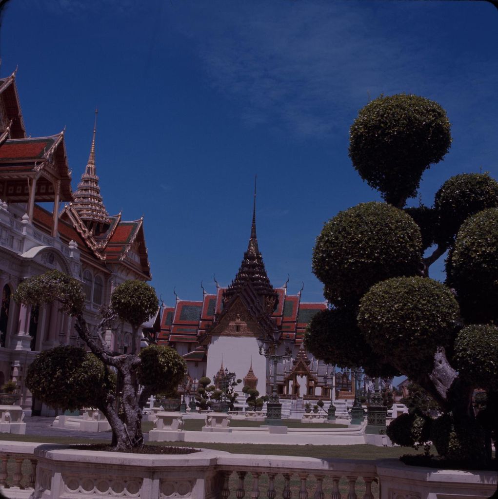
Chakri Maha Prasad and Dusit Maha Prasad at Bangkok's Grand Palace, photographed by Sherwin John Carlquist around September 1967. Europeanising façades and Thai roof forms record a specific royal commission rather than passive stylistic copying. Sherwin John Carlquist, Chakri Maha Prasad and Dusit Maha Prasad at the Grand Palace; CC BY 4.0. JPEG prepared; no crop or retouch.
Masonry façades, classical details and imported systems entered compounds that still relied on Thai labour, climate responses and social organisation. Calling them “Western” hides the clients and builders who adapted them.
Chinese migration and commerce had equally significant effects on shophouses, warehouses, shrines and urban districts. These were not marginal additions to a sealed national tradition; they were part of city making.
Watch: Thai Architecture from Sukhothai to Structural Reading
Begin with Sukhothai as a connected historic landscape, then widen the view to structure, enclosure, climate and movement without flattening Thailand’s regional and institutional differences.
Historic Town of Sukhothai and Associated Historic Towns
UNESCO's concise survey introduces Sukhothai's monuments and the regional synthesis associated with the historic towns. Use it alongside the page's archaeological cautions about roads, water, production and ordinary settlement beyond the frame.
Watch on YouTubeModern architecture addressed a changing state
Twentieth-century architects used reinforced concrete, steel, mechanical systems and modern planning for government buildings, universities, housing, hotels and transport. Chulalongkorn and Silpakorn universities became important settings for architectural education and professional debate [20] [21].
Modern Thai work ranged from state monumentality to climate-responsive campuses and experimental houses. Concrete brise-soleil, shaded walkways and courtyards could reduce heat gain. Formal references to roofs or stupas sometimes negotiated identity, but they were deliberate modern choices rather than survival of an instinctive style.
Post-war growth also produced factories, worker housing, highways, airports and large commercial interiors. These ordinary systems reorganised settlement at a scale that single landmark buildings cannot explain. Architectural evidence includes standard drawings, engineering reports, property records and users' accounts, not only architects' presentation models.
DOCOMOMO Thailand draws attention to recent buildings vulnerable to redevelopment [23]. Modern heritage can disappear before archives, drawings and user memories are collected.
Conservation operates in living places
Thailand's Fine Arts Department administers legal designation and conservation of monuments, while monasteries, communities and owners carry daily responsibility. ICOMOS Thailand contributes professional research and heritage debate [22]. UNESCO Bangkok places conservation within regional cultural policy and capacity building [12].
Repair at an active wat must consider worship, ordination, festivals and resident monks. Archaeological parks have different needs around ruin stabilisation, interpretation and landscape. One conservation rule cannot serve every programme.
Flood, tourism and development are linked
Ayutthaya's low river setting faces serious flood risk. Drainage, embankments and upstream decisions influence both monuments and present neighbourhoods. Protecting masonry while transferring water damage to residents would be a failed heritage response.
Tourism supports employment and repairs but concentrates wear and may replace housing with visitor services. Bangkok development can disrupt historic canals and sight lines. Good stewardship combines documentation, compatible use, local participation and climate planning.
Conservation must also manage air pollution, vibration and incompatible drainage around masonry and timber. Fire detection at active monasteries needs to coexist with lamps, incense and festivals. Training local maintenance teams can prevent small roof or gutter faults from becoming major structural interventions.
The Siam Society's publications and the Southeast Asia Digital Library preserve research, maps, photographs and texts that can recover altered places [13] [14]. Archives still require source criticism: colonial and elite observers did not record every user equally.
How to read Thai architecture
First identify region, period and polity rather than assuming present Thailand. Determine whether the place is a monastery, palace, house, market, fortification, school or infrastructure. Within a wat, name the component and its ritual function.
Next trace materials and labour. Separate masonry core from plaster, timber frame from enclosure, and original fabric from repair. Ask where brick, tile, timber, glass and metal came from and who maintained them.
Finally map water, streets, settlement and exchange. A monument's form becomes clearer when connected to canals, fields, merchant quarters, workshops and living communities.
Record uncertainty wherever the surviving evidence remains incomplete.
Thai Architecture: Five Evidence Tests
Begin with a dated region and institution, then connect structure and climate to routes, religious change, ordinary use and present stewardship.
| Evidence | What it can establish | What else to verify |
|---|---|---|
| Region and institution | Settlement, wat, palace, house, market and infrastructure organise distinct spaces. | Bangkok court buildings cannot represent every Thai region or programme. |
| Material and climate | Timber, brick, laterite, plaster, tile, raised floors and deep eaves reveal construction choices. | Separate original fabric from replacement, restoration and devotional maintenance. |
| Route and water | Roads, rivers, canals, moats, courts and processional paths shape access and settlement. | Water serves several purposes and does not prove uniform royal control. |
| Religion and exchange | Theravada, Mahayana, Hindu, Chinese, Malay and European connections entered locally authored institutions. | A borrowed detail does not identify the building's makers or users by itself. |
| Afterlife and stewardship | War, repair, urbanisation, tourism, climate and living use shape surviving evidence. | Identify residents, monastics, craftspeople, owners and public authorities. |
Frequently Asked Questions
No. Buddhist monasteries are prominent, but the history includes houses, palaces, civic works, mosques, churches, markets, industry and infrastructure.
It is a monastic or temple institution containing several building types, not the name of one standard hall.
No. Both can be monumental religious structures, but their forms, functions and historical associations differ. Site-specific terminology is best.
Multiple tiers can span complex halls, shed rain and mark status. They are engineered and maintained systems, not merely decoration.
Regional knowledge moved through political and religious networks. Thai patrons and craftspeople transformed selected Khmer and other precedents within new institutions.
The old royal city was not rebuilt after 1767, but the wider modern city remains inhabited around its archaeological monuments.
No. Raised timber construction is common, but plan, roof, material and use vary significantly by region and household.
No. Active monasteries and houses need change. Good conservation documents alterations and protects significant material, function and community authority.
Discussion
Which Thai building or landscape most clearly shows why region, institution, material, climate and historical change must be read together?
Reader Insights
Which place, period, institution and community make the example historically specific?
How do frame, roof, platform, enclosure, route, water and landscape work together?
What changed through war, repair, reconstruction, urbanisation, tourism or continuing use, and which communities and authorities shape interpretation now?
Join the Conversation
Share a documented Thai example below, noting its place, programme, makers, materials, date, regional context and evidence limits.
References
- Getty Research Institute, “Getty Vocabularies,” View source
- UNESCO World Heritage Centre, “Ban Chiang Archaeological Site,” View source
- UNESCO World Heritage Centre, “The Ancient Town of Si Thep and its Associated Dvaravati Monuments,” View source
- UNESCO World Heritage Centre, “Phu Phrabat, a testimony to the Sima stone tradition of the Dvaravati period,” View source
- UNESCO World Heritage Centre, “Historic Town of Sukhothai and Associated Historic Towns,” View source
- UNESCO World Heritage Centre, “Historic City of Ayutthaya,” View source
- UNESCO World Heritage Centre, “Monuments, Sites and Cultural Landscape of Chiang Mai, Capital of Lanna,” View source
- UNESCO World Heritage Centre, “Wat Phra Mahathat Woramahawihan, Nakhon Si Thammarat,” View source
- Fine Arts Department, Thailand, “Fine Arts Department,” View source
- Fine Arts Department, Thailand, “Virtual Museum Thailand,” View source
- National Museum Bangkok, “National Museum Bangkok,” View source
- UNESCO Bangkok, “Culture and heritage in Thailand,” View source
- Siam Society Under Royal Patronage, “Siam Society Publications,” View source
- Southeast Asia Digital Library, “Thailand collections,” View source
- Smarthistory, “Sukhothai and the beginnings of Thai art,” View source
- Smarthistory, “Buddhist art and architecture in Thailand,” View source
- Metropolitan Museum of Art, “Thailand, 1000–1400 A.D.,” View source
- Metropolitan Museum of Art, “Thailand, 1400–1600 A.D.,” View source
- Metropolitan Museum of Art, “Thailand, 1600–1800 A.D.,” View source
- Chulalongkorn University, “Faculty of Architecture,” View source
- Silpakorn University, “Faculty of Architecture,” View source
- ICOMOS Thailand, “ICOMOS Thailand,” View source
- DOCOMOMO Thailand, “DOCOMOMO Thailand,” View source
- Bangkok Metropolitan Administration, “Rattanakosin and Old Town conservation,” View source