by Tom Gurney
Tom Gurney BSc (Hons) is an art history expert with over 20 years experience
Email: tomgurney1@gmail.com / Phone: +44 7429 011000
Two Cliff Temples, Two Historical Sites
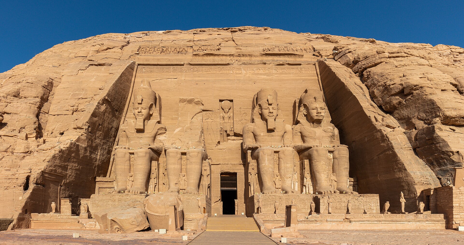
Abu Simbel is two temples cut into a sandstone cliff in the ancient Nubian reach of the Nile, not a single façade of four giant kings. Ramesses II's Great Temple advances from a solar and royal cliff-front through halls crowded with war and offering scenes to a shrine where the king sits beside three gods. A shorter temple to the north honours Hathor of Ibshek and Queen Nefertari. Its six standing façade figures, Hathor-headed pillars, paired coronations and cow-shaped sanctuary give the queen a substantial ritual presence, though royal precedence is never simply abolished. The pair was carved for an occupied, politically contested river region rather than a vacant desert. Today the stone survives beside Lake Nasser because it was cut into numbered blocks, moved and assembled inside a newly constructed hill. The ancient façade, modern concrete structure and lost riverbank must be read together. [1][2][3][4][5][6][10][13][18]
The Great Temple's fallen colossus, still lying at the foot of the façade, makes the point visually. Its collapse predates the modern rescue, while the seams beside it belong to twentieth-century reassembly. The surviving sculpture is neither an untouched original cliff nor a replica. It is ancient carved stone in an engineered setting, with changed approaches, light and shore. These changes preserve extraordinarily detailed rooms but also make every apparently timeless photograph a view of two historical moments at once. [1][3][5][10][13]
At a Glance
- PlaceAncient Lower Nubia, on the Nile's western bank near the former second-cataract reach; the present shore is Lake Nasser. [1][2][5][13]
- PairThe Great Temple of Ramesses II and the smaller northern temple of Hathor of Ibshek and Nefertari. [1][6][13]
- Patron and ageRamesses II of the Nineteenth Dynasty, New Kingdom; the Egyptian monuments record gives about 1264 BCE as a broad context, not a securely known construction-start day. [1][6]
- Great façadeFour seated king-colossi about 20–21 metres high around a small doorway; one fell in antiquity and remains in fragments below. [1][5][13]
- Great interiorEight Osiride pillar-fronts in the first hall, subsidiary rooms, a four-pillar hall, transverse space and four-figure inner shrine. [5][9][13]
- Great shrinePtah, Amun-Ra, deified Ramesses II and Ra-Horakhty. Modern late-February and late-October sun reaches the other three while Ptah remains dark. [1][10][13]
- Small façadeSix roughly ten-metre standing colossi: four of the king and two of Nefertari, similarly tall but not identically distributed. [1][6][13]
- Small interiorA six-pillar Hathor hall, vestibule with side chambers and sanctuary containing the rock-cut Hathor cow and smaller king. [6][8][13]
- RelocationDuring the multinational rescue, the two temples were dismantled and raised above the future reservoir; an original engineer records a 208-metre north-westward transfer, the Great Temple 65 metres higher and the Small Temple 67 metres higher. UNESCO uses rounded public figures of about 180 metres inland and 64 metres higher. [3][4][5]
- World HeritageOne component of UNESCO's ten-part serial property Nubian Monuments from Abu Simbel to Philae, inscribed in 1979—not an independent Abu Simbel-only listing. [2]
Contents
- A royal cliff in a populated Nubian river world
- The Great Temple: a pylon cut from the mountain
- Qadesh is a carved royal argument, not a battle report
- From royal hall to the dark, seated four
- Nefertari's temple: height, order and Hathor's pillars
- Images before and after the sand
- Cutting a cliff into a movable monument
- The hidden modern architecture and the untransferred landscape
A royal cliff in a populated Nubian river world
The original temples faced a bend of the Nile from a sandstone rock wall on its west bank. The ground, river, vegetation and eastern horizon were more than scenery. A person arriving by boat met the colossal façades across a working waterway; carved rooms then carried that approach inward and away from open sun. William John Bankes' 1815 view of the Small Temple shows the Nile close to its front, with a boat and vegetation between water and stone. The drawing is not a measured ancient landscape survey, yet it preserves a riverbank relationship that today's wide lake-stage image cannot reproduce. A modern archaeoastronomical survey likewise notes that the original eastern ridges and valleys made a different horizon from the flatter vista now seen across the reservoir. [5][10][14]
Ramesses II's pair belonged to a network of seven temples he commissioned in Lower Nubia. Local cult names such as Horus of Meha and Hathor of Ibshek make more sense in that regional network than in a formula that simply exports Egyptian gods south. Nile transport, gold, timber, ivory, incense, soldiers and labour connected this region to Egyptian power; those connections included extraction and domination. The king's campaign scenes and enlarged body proclaim authority at a border whose inhabitants and resources mattered. Nubia was not an empty stage on which a lone pharaoh invented civilisation. Earlier Egyptian and Nubian building, worship, settlement and travel formed the ground on which his monumental intervention was made. [2][6][13]
Neither a single exact first-cut date nor a confidently fixed twenty-year building period follows from the surviving accounts. The monument record places the work broadly in Ramesses' reign. Later travellers and modern summaries assign different completion regnal years, and a date for one relief programme is not a completion certificate for two entire rock temples. The useful chronological fact is the Nineteenth-Dynasty royal project; the useful architectural question is how its cliff faces, rooms and images turned regional command into a journey. [1][6][13][14][15]

Text alternative for the diagram
An ancient natural cliff with a close Nile and varied eastern horizon contrasts with rejoined stone, modern hill, raised shore and lake.
The Great Temple: a pylon cut from the mountain
The Great Temple looks at first like a freestanding Egyptian pylon, with a battered outline, tall vertical sides and monumental entry. In fact its face and passage were hewn from living sandstone. Four seated Ramesses figures, each approximately twenty to twenty-one metres high, dominate the façade. The doorway between the middle pair is comparatively narrow. This disparity makes the king's scale a threshold device: before a visitor reaches any dark hall, the landscape has already been changed into a royal body and an architectural gate. The third figure fell after an ancient earthquake and was not set upright during the modern transfer. The fragments at its feet interrupt the ideal symmetry, preserving a history of damage rather than completing a modern four-statue tableau. [1][5][13]
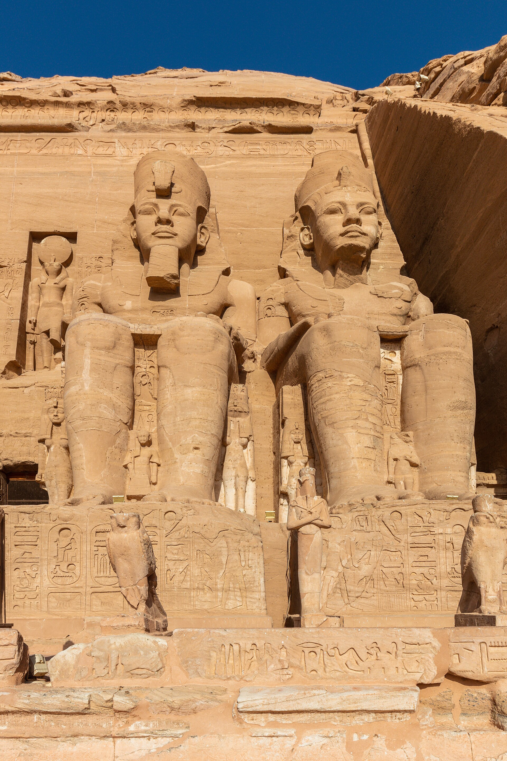
The giant figures are not the only people carved there. Queens and royal children appear by the colossi's legs, and the difference in scale asserts family hierarchy. A frieze of baboons across the upper face greets the rising sun; above the portal, a niche with Ra-Horakhty and hieroglyphic signs brings solar divinity and the king's names into the entry composition. Cliff edge, sculpted crown, smaller dependent figures and bright central axis are made to act as one façade. The visual statement is political as well as sacred, especially when its reliefs of foreign captives are considered in the Nubian setting where it was built. [13][14]
The front also gathered marks from people centuries after Ramesses. Greek, Phoenician and Carian visitors left inscriptions on the colossi; a Greek inscription associated with a Psammetichus-period Nubian expedition is one of the most important. These marks are not original Ramesside decoration and should not be read as such, but they show ancient travellers reusing the royal surface as a place to record presence. Later sand, earthquakes, re-cutting, nineteenth-century copying and twentieth-century seams made the façade a palimpsest well before tourists began to call it a preserved masterpiece. [14]
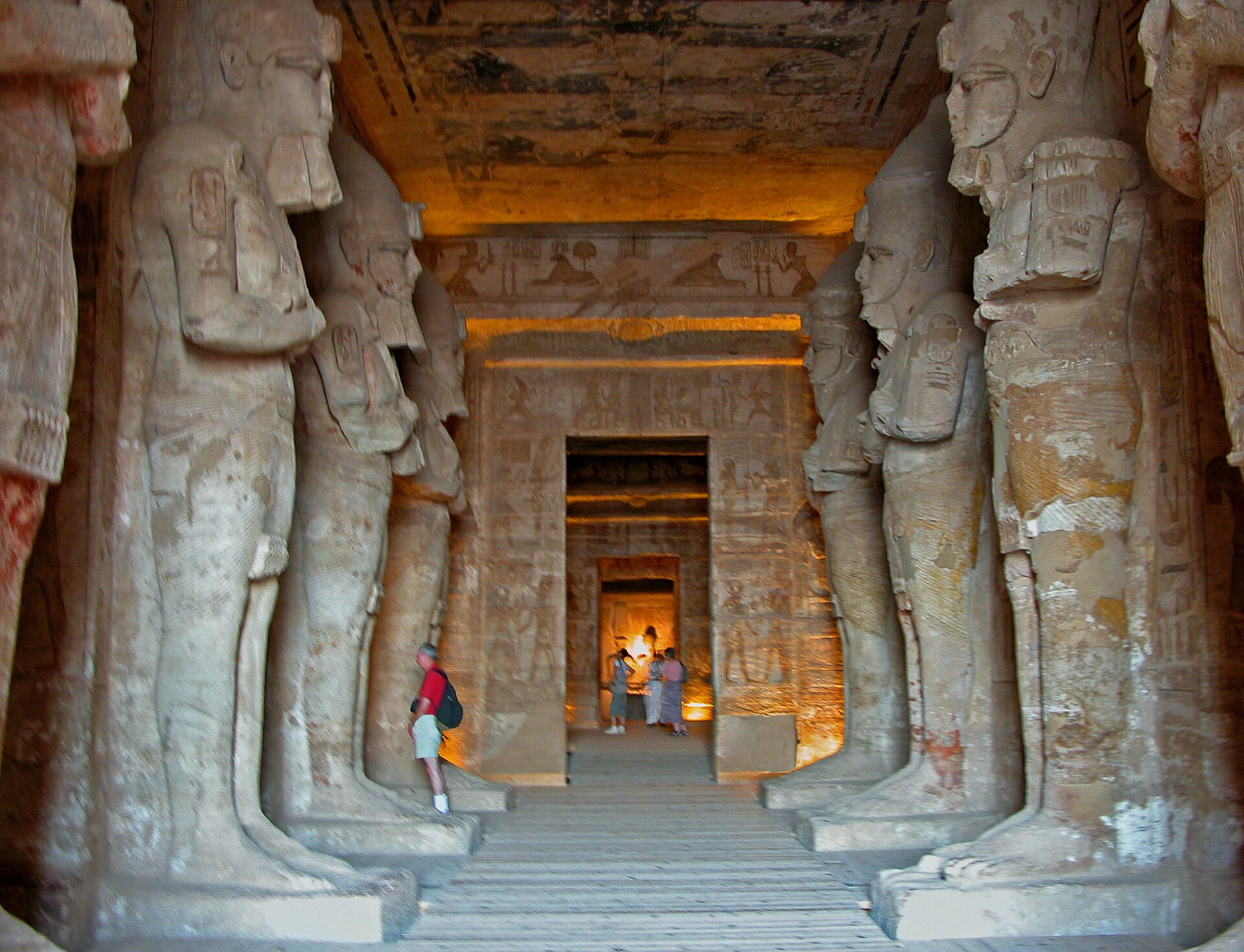
Behind the door, an engineer's original survey places the first hall at roughly eighteen by sixteen metres and eight metres high. Two ranks of four king-shaped Osiride pillar-fronts organise the central line. Their bodies face the corridor, giving a procession repeated royal encounters rather than a neutral forest of supports. Side and rear faces carry gods, kings and offerings; a later specialist monograph studies forty-eight additional carved panels as well as the eight pillar fronts. The proportions, surfaces and painted traces therefore resist the convenient name “hypostyle hall” if that name suggests only column engineering. Every support was also an image-bearing station. [5][9][13][14]
Nefertari herself appears offering sistra to Hathor on the side of a Great Temple pillar, recorded in Bankes' early drawing catalogue. The Great Temple's overall programme puts the king in front, but the queen is not absent from it; nor is the Small Temple merely a separated “women's annex.” The two façades set different emphases within a shared royal and divine scheme. Older watercolours and text copies also record traces of yellow, red, black and perhaps other colour. Their finished sheets sometimes reconstruct what could not be seen clearly, so they cannot supply an exact colour map. They do, however, challenge the modern assumption that pale sandstone under electric light was always the interior's visual condition. [6][14]
Qadesh is a carved royal argument, not a battle report
The northern first-hall wall displays Ramesses' campaign against the Hittites at Qadesh in his fifth regnal year. Egyptian court accounts known as the Poem and Bulletin are distinct modes of telling that campaign. Both place royal action and divine support at the centre; neither is a detached field diary. An image of a chariot-driving king overcoming enemy forces is therefore evidence of how a ruler represented his power, not independent proof of an unambiguous Egyptian military victory. The wider outcome remains disputed in modern scholarship, and Ramesses did not simply obtain every Syrian objective pictured as royal success. The later Egyptian–Hittite treaty should not be mechanically made the immediate result of the depicted clash. [13][15][16][24]
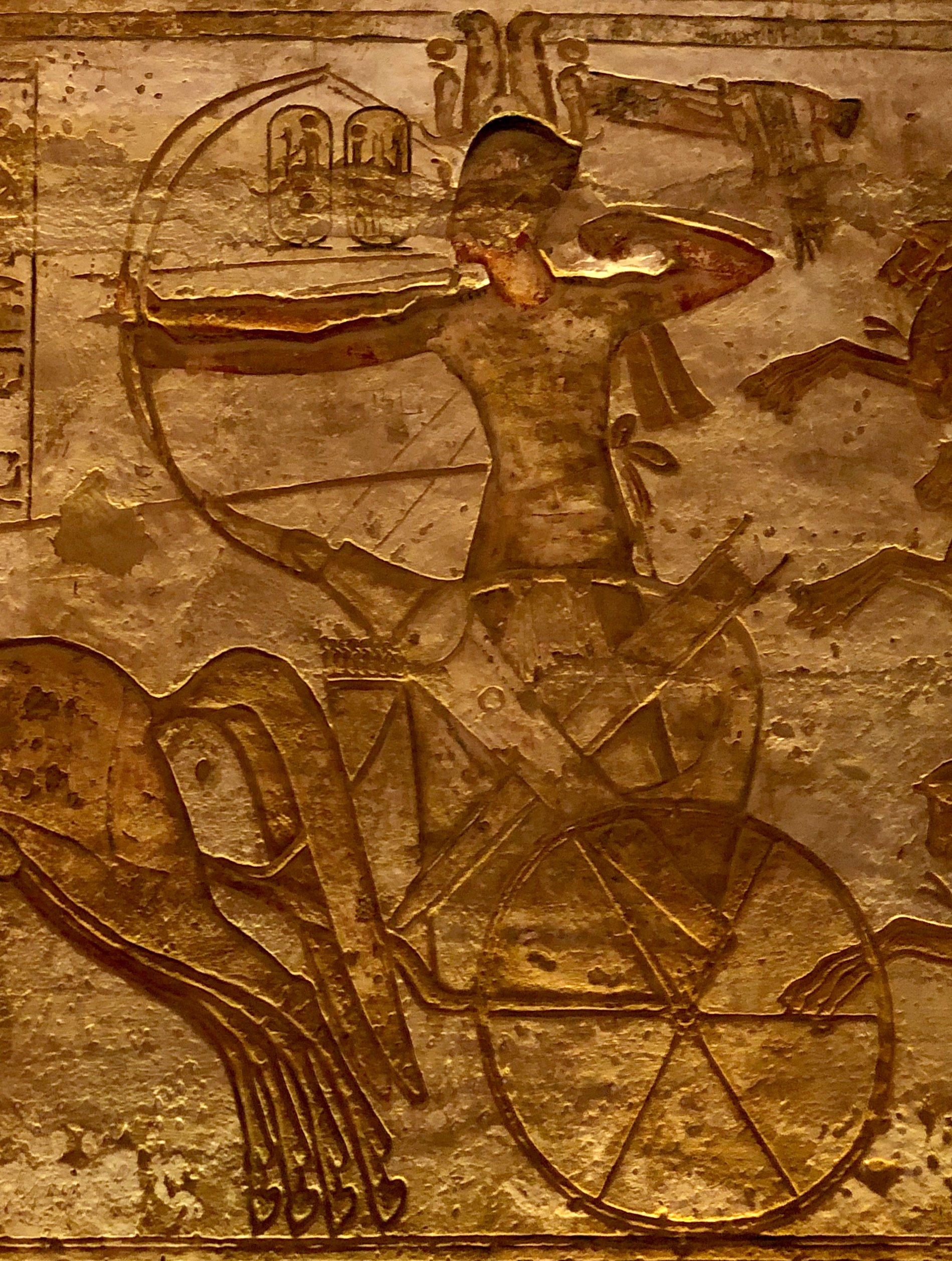
The carved panorama has a fuller range of figures than the famous hero scene alone. A University of Chicago Epigraphic Survey visit describes the Egyptian camp, workers repairing chariot wheels, cooking, a medical attendant, spies, the Orontes River and a fortified town. These observed details put supply, care and intelligence beside the king's spectacular counterattack. Some specific labels depend on the accuracy of scene identification, but the diversity of labour is visible. The large wall translates a military undertaking into a controlled palace narrative while still leaving work and vulnerability inside that narrative. Opposite and entrance-side scenes include other enemy identities—Asiatic, Libyan and Nubian—so the temple's imagery is not a single mural of one Syrian battlefield. [13][14][15][25]
Older European copies of the Qadesh wall are useful but incomplete: Bankes' 1819 record did not finish important horses and central text, and later painted reconstructions regularised details. The stone relief, copied lines and Egyptian court narratives each offer a different window onto the programme. A traveller's impressive lithograph may preserve a view of colour and surface then visible, yet it should not quietly replace a direct reading of the wall with a polished, imagined victory. [14][15][16]
From royal hall to the dark, seated four
Rooms beside the Great Temple's first hall complicate any one straight-axis description. They are often called treasuries or stores, but the labels are traditional and their exact original functions are not proven merely by their small plan. They might have housed equipment associated with rites, offerings or the building's service life; the evidence does not require one uniform name for every side chamber. The main route continues through a second hall of four pillars, where bark and offering scenes replace the scale of the outer war programme. A transverse space then prepares the approach to the deep sanctuary. The engineer's section makes the shrine about sixty metres inside the former cliff, a physical retreat from direct outdoor sun into narrow, framed illumination. [5][13]

Text alternative for the diagram
From four façade king-colossi, the route crosses the eight-front first hall and side rooms, four-pillar second hall, transverse room and sanctuary of Ptah, Amun-Ra, deified Ramesses and Ra-Horakhty.
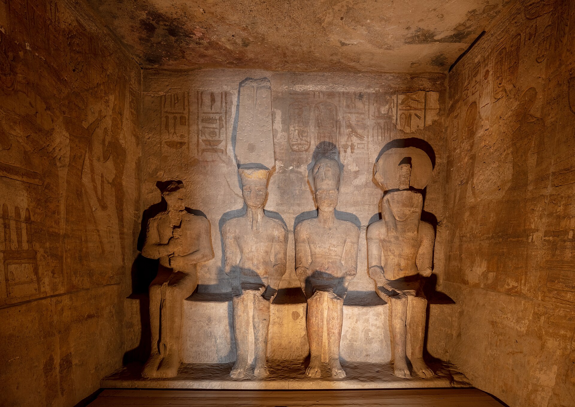
At the back, four seated sculptures link local stone, king and gods. From left to right they are Ptah, Amun-Ra, the deified Ramesses and Ra-Horakhty. The king's placement among them is not a claim that the whole temple was “for Ramesses alone.” It is a constructed, sculpted equivalence, reached only after his colossal exterior bodies and repeated pillar fronts have led the visitor inward. Ptah's dark position adds an important distinction to the familiar tale that “the sunlight lights all the gods.” It does not. [1][10][13]
Twice each solar year, a shaft of dawn light travels down the Great Temple's passage and reaches Amun-Ra, the deified king and Ra-Horakhty while Ptah remains unlit. The Egyptian monuments authority gives the present observations as 22 February and 22 October. A field survey saw the three illuminated figures on 22 February 2004. An older account recorded old-site observations around the twenty-first; a changed horizon, orientation tolerances and changing civil calendars mean that two date labels cannot be turned into one immutable ancient day. February and October are also not the astronomical equinoxes. The widely repeated explanation that the days were specifically Ramesses' birthday and coronation anniversary has no secure ancient proof. Light, axis and divine grouping are tangible; the precise festival purpose remains an interpretation. [1][10][13]
The Small Temple's measured axis differs substantially from the Great Temple's. The field survey gives approximate azimuths of 100 degrees for the Great and 142 degrees for the Small. It is thus misleading to narrate both buildings as if they shared one identical sun-channel design. Today the two façades retain their mutual placement and broad directions as accurately as the relocation allowed, but the old riverbank horizon was not carried into the new site. The effect observed now is an important continuation of a temple's design, not a perfect replay of an ancient sunrise against its original hills. [5][10]
Nefertari's temple: height, order and Hathor's pillars
The northern temple's façade is smaller than its neighbour's but not a miniature copy. Six standing figures, around ten metres high, stand in its rock face: four of Ramesses and two of Nefertari. The queen's figures reach comparable height to the king's, an exceptional public prominence in the language of Egyptian monumental scale. Yet count, portal placement, inscriptions and precedence retain distinctions. Four kings beside two queens is not complete parity; similarly sized bodies also cannot reduce the queen to scenery. Named royal children are carved by the larger figures' feet, including daughters identified in epigraphic study. The word “family” should therefore not make the small figures anonymous, even where weathering prevents every identification in a passing view. [1][6][7][13]
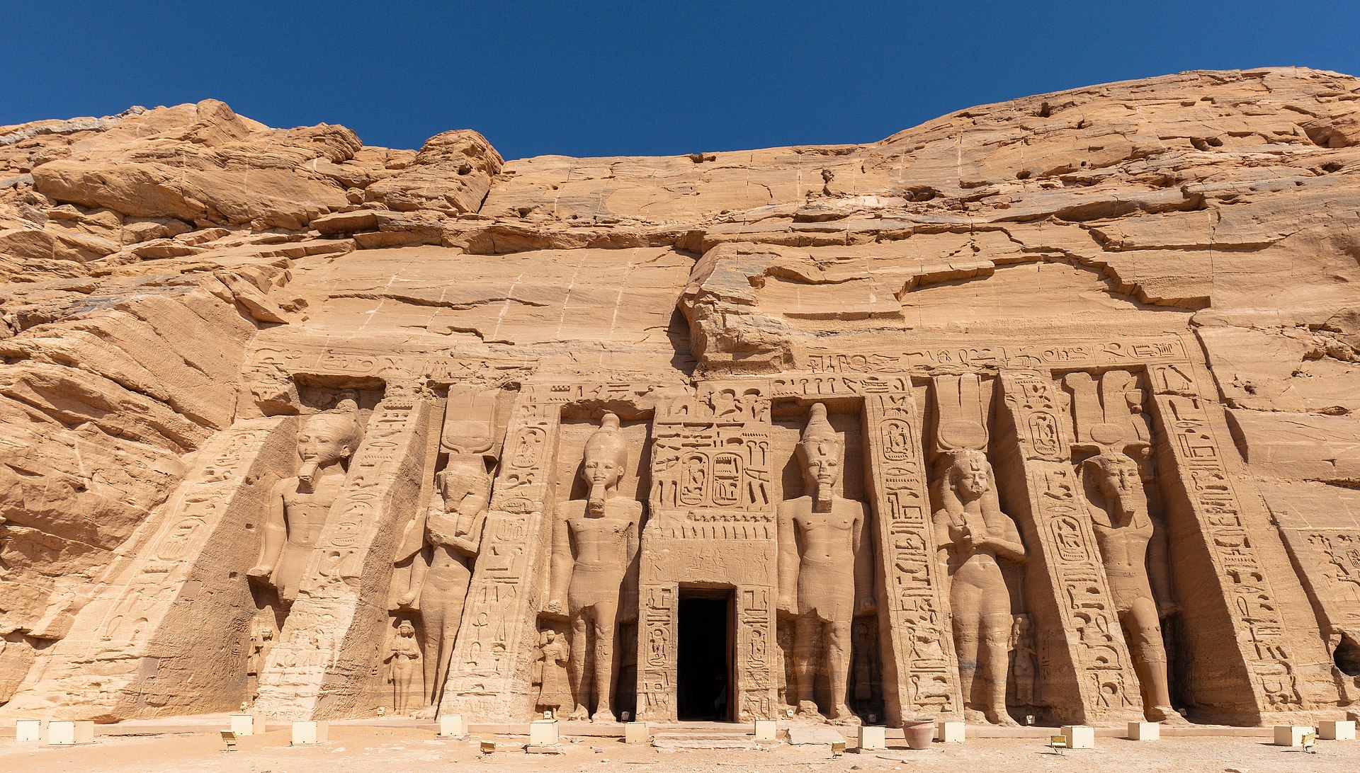
A short portico leads into a six-pillar hall, two rows of three supports. Hathor-headed naos-sistrum fronts face the route. Their goddess associations include Anuket, Hathor, Isis, Mut, Satet and Weret-Hekau, joining a Nubian river setting to a wider Egyptian female divine ensemble. These are not generic structural columns with decorative masks added as an afterthought: the sistrum shape, repeated divine heads, ceiling cartouches and royal offerings turn the path into a musical, ceremonial and image-rich entry. A queen-dedication text and alternating royal names above reinforce a dual programme while the corridor still directs attention towards the rear shrine. [6][13]

Text alternative for the diagram
The Small Temple has six standing exterior figures, short portico, two rows of three Hathor-headed pillars, transverse vestibule with side rooms and cow-shaped Hathor sanctuary.
The inner entrance wall shows Ramesses smiting an Asiatic and a Nubian under divine witness. Such political imagery belongs in Nefertari's temple as well as the king's, so “female” cannot be substituted for “peaceful.” Other hall scenes give the queen her own ritual actions. She offers, carries the sistrum and appears before named goddesses; she is not restricted to following Ramesses through the rooms. In a close count of surviving two-dimensional images, the Oxford researcher Edward Scrivens found thirty-eight goddess appearances among sixty-three divine figures and seventeen queen appearances among thirty-five royal ones, near the eighteen of the king. Those figures depend on what scenes the researcher counts and how worn surfaces are classified; they are useful evidence of this temple's dense queen/goddess programme, not a universal Egyptian-temple ratio. [6][14]
A transverse vestibule follows the hall. Its two side chambers complicate the route, while opposing coronation scenes confer rank on both rulers: Horus and Seth crown Ramesses, and Hathor and Isis crown Nefertari. The relation is not a modern equal-rights allegory but a careful ancient juxtaposition of royal and divine credentials. Repeated offerings by the queen, including scenes before Anuket, Hathor and Mut in early copies, place her action along the movement into the sanctuary. Some copied text has since worn from the stone, a reminder that the earliest drawings can preserve information even when their pictorial forms are not measured representations. [6][14]
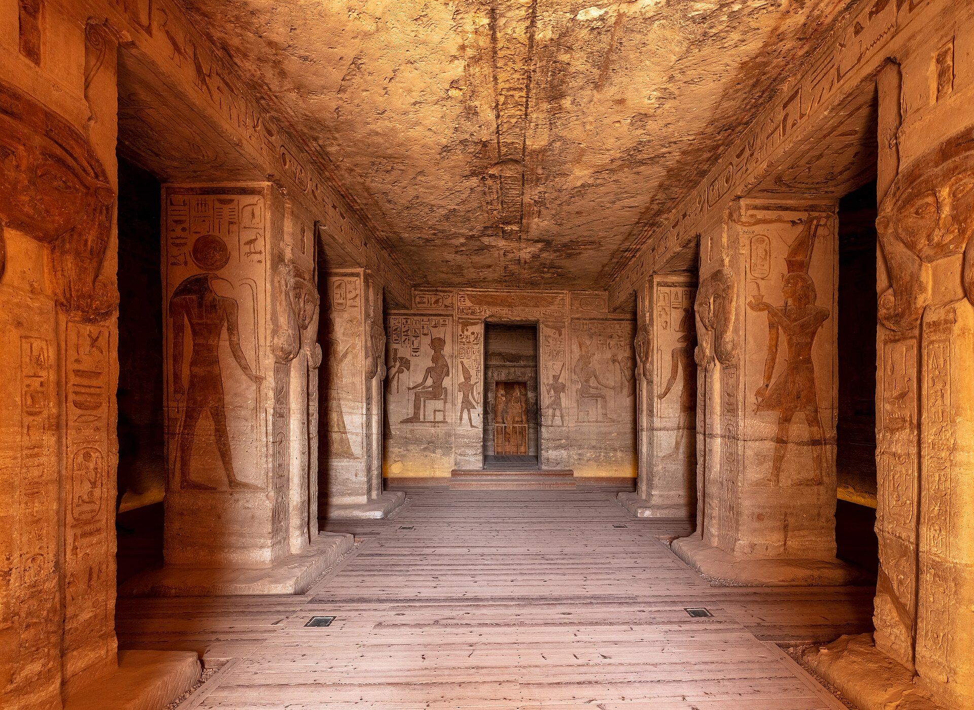
The rear sanctuary centres on Hathor emerging as a rock-cut cow. A smaller king stands beneath her chin and offers; the bovine figure sits slightly off the wall's geometric centre rather than supplying a perfectly symmetrical modern stage. On another sanctuary wall the king and queen are deified together. These images express the paired temple's strongest theological link without erasing Hathor's local title or the king's seniority in other parts of the programme. The queen's large exterior bodies and interior agency meet a sanctuary in which goddess, king and couple are not interchangeable. [6][8][13]
Scrivens proposes that approaching or leaving the shrine changes which royal and divine figures are visible among the pillars and portals. That experiential model fits the architecture: a narrow passage makes bodies appear, disappear and reappear, while opposed scenes answer each other across it. It remains a modern reading of spatial effects, not a surviving instruction from the ancient builders saying exactly where every visitor should stand. A once-popular account treats the entire Small Temple as a device to ensure the Nile flood or a particular Sothis event. The river mattered to Hathor of Ibshek and to Nubian life, but the variety of queen, coronation, frontier and goddess scenes and the temple's distinct orientation do not establish one exclusive flood-control function. [6][10]
Images before and after the sand
The Abu Simbel façades had histories of exposure and burial before the dam. Burckhardt reported visible parts to European readers in 1813; Belzoni and a party entered the Great Temple in 1817 after clearance work. Bankes, Ricci, Beechey and others recorded different stages of sand, colour, inscriptions and access. Calling one traveller the “discoverer” of a monument known in a Nubian landscape erases local residents and the labour of Nubians hired to clear its entrance. The derogatory language in some traveller accounts reveals their colonial assumptions more clearly than it documents fair wages or workers' wishes. A European reception chronology is still valuable when it is not mistaken for the temple's first human encounter. [13][14][15]
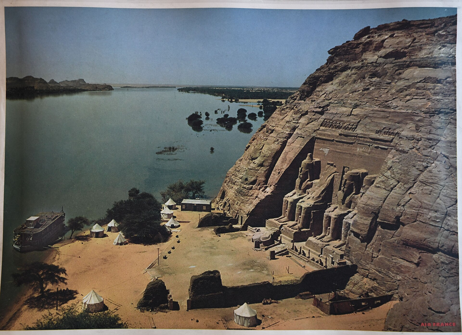
The resulting drawings are neither useless fantasy nor perfect archaeological elevation. Ricci's watercolours and Bankes' notebooks record paint and carved text that may now be obscure; some finished sheets were worked up away from the site. Bankes' elaborate Small Temple interior image Europeanised people and arranged its plan as a visual composition. His hypothetical view of a buried Great Temple façade depicted the four kings standing, despite the ancient fallen figure. David Roberts' later picturesque images idealised proportions and added ornaments, including sphinxes, noted by a Spanish study of the nineteenth-century representations. A historic print tells us about its maker's eye and an earlier stage of preservation. It cannot silently tell us that every ornament or ratio in its frame belonged to Ramesses' cliff. [14][15]
Ancient graffiti offer a different afterlife again. The Greek, Phoenician and Carian names on the colossi were not the work of European tourists, and the old Nile remained a route through the monumental frontage. These traces, the riverbank vegetation in an 1815 view, the old colour notes and the later sand stages extend Abu Simbel beyond the single Ramesside dedicatory moment. They make the temple a place people continued to approach, mark, describe and work on—sometimes with radically different control over the record they left. [14]
Cutting a cliff into a movable monument
The Aswan High Dam made the original low river setting untenable as Lake Nasser rose. Egypt and Sudan requested UNESCO's help in 1959, and a 1960 international appeal brought together recording, excavation and salvage across Nubia. The Abu Simbel operation was one demanding part of a wider campaign involving engineers, archaeologists, governments and contributors from many countries; the rescue of selected temples was not the entire campaign's purpose or result. Before cutting, the old site required a cofferdam, groundwater pumping, protective excavation and temporary supports inside the rooms. The surrounding sandstone above them could be removed only after the surfaces below were stabilised. [3][4][5]

Text alternative for the diagram
Cofferdam and numbered blocks at the old low cliff lead to reassembled ancient stone in a modern raised site; the old river, settlements and bedrock did not move.
The sculpted stone was then divided and numbered. UNESCO's public account describes more than a thousand blocks; a contemporary Arabic guide gives 1,042 in its counting convention. The original engineer specifies weight limits of about thirty tonnes for façade pieces and twenty for interior room pieces. Fine visible cuts on delicate fronts were hand-sawn to seams around eight millimetres or less, placed to avoid faces and important carving where possible. Deeper parts used machinery and wedge splitting. Wire saws were prominent at early stages, especially in natural rock, but a simplified picture of one wire slicing every finished relief misstates the mixed methods. Generally only a layer of wall stone—about eighty centimetres in many interior areas—travelled, not the entire former mountain. The project's brilliance and its irreversible subtraction of surrounding cliff are both material facts. [3][5][13]
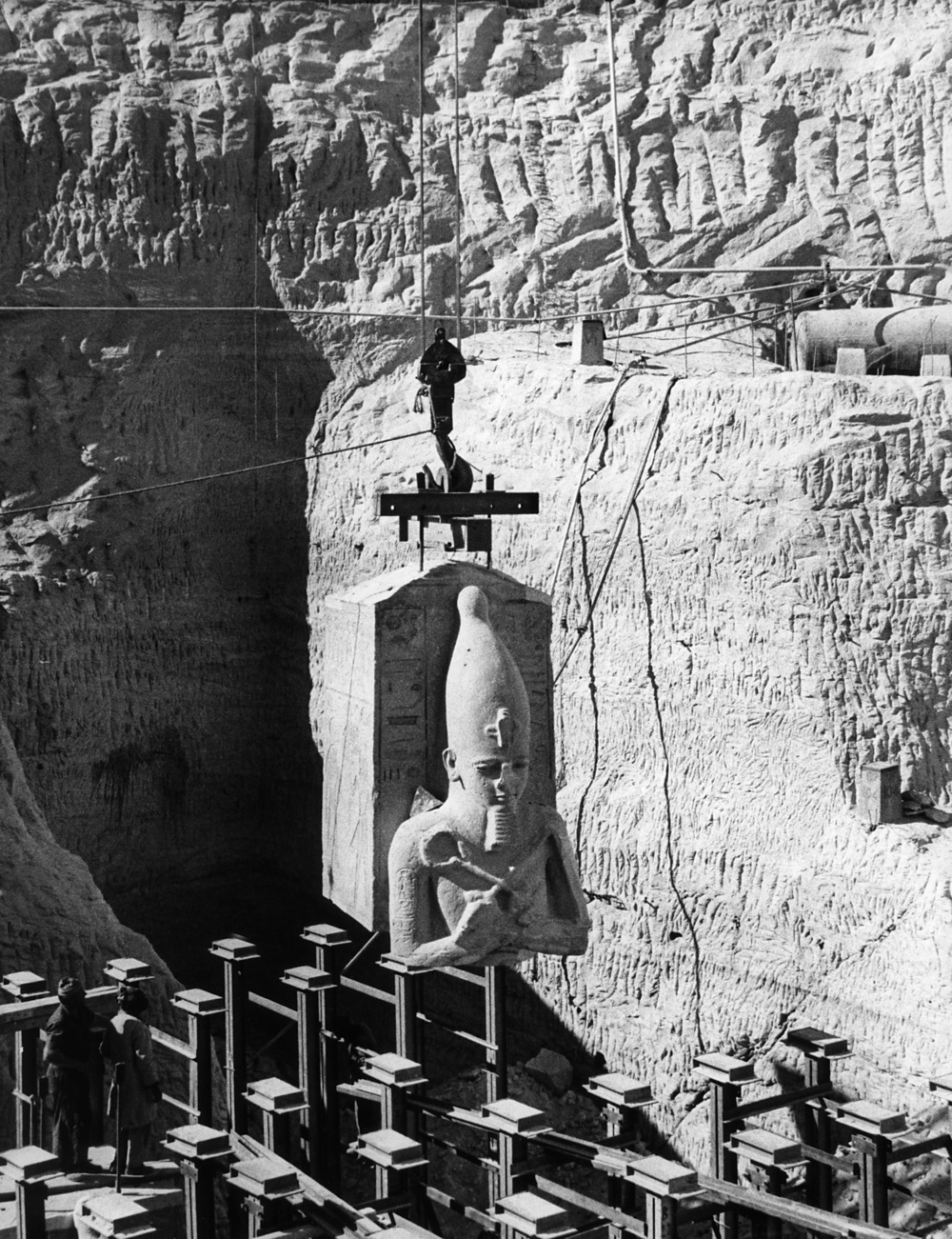
The rebuilt temples were raised and shifted north-west. UNESCO's retrospective says about sixty-four metres higher and 180 metres inland; Lennart Berg's engineering article gives a common horizontal translation of 208 metres, with the Great Temple sixty-five metres and the Small Temple sixty-seven metres above their old positions. These are differently rounded and specified measures from different accounts, not an invitation to average them into a supposedly exact 190-metre move. The team kept the buildings' mutual layout and directional relation as closely as feasible, partly to retain the Great Temple's axis of light. It could move blocks and orientation; it could not move the old river, eastern ridge line, settlement or bedrock mass around them. [3][5][10]
An inauguration took place on 22 September 1968, while landscape and finishing work extended after that public moment. The wider Nubian campaign continued to 1980. An original engineering account estimates roughly US$40 million for Abu Simbel itself; UNESCO's often cited US$80 million belongs to the whole international Nubian campaign. Treating either sum as the timeless value of saved heritage would obscure what money and technology could—and could not—carry beyond the reservoir. [3][4][5][13]
The hidden modern architecture and the untransferred landscape
The present hill is a constructed envelope. Rejoined sandstone surfaces rest against concrete braces; separate large domes protect the temples from the artificial mound rather than relying on the ancient cliff that no longer exists behind them. Berg describes the Great Temple dome as about sixty metres in clear span and twenty-five metres high. The outward hill was stylised to suggest a natural ridge rather than reproduce every original contour. Protective coatings, filled seams, ventilation, lighting and drainage made a new conservation environment around old sculpture. A visitor sees chiefly stone because the modern supporting section is deliberately hidden, not because it is absent. [5]

Modern recording adds another layer without proving that the site is immune to change. A 2023 Egyptian geomatics study abstract reports a network and fifty-two laser scans of façade and interior geometry. Such a point cloud can form a comparison baseline for future conservation; it is not, by itself, a measured trend of damage or a certificate of perfect 2026 condition. Visitor numbers, lighting, moisture, joints and surfaces remain management questions in an engineered sandstone setting. The present wood floors and electric light noted by twentieth-century researchers make rooms legible to tourists but should not be imagined as ancient fittings. [5][11][25]
Stone rescue was also an uneven rescue of place. Nubian villages, farmland, palms, paths and homes could not be cut into numbered architectural blocks. Displacement around the dam affected people on Egyptian and Sudanese sides, with families carrying memory into new settlements and cultural forms. A University of Michigan Nubian-focused account distinguishes the dam's electricity and flood-control benefits from drowned homes, trees and local memories; an American University in Cairo project examines music as one way of carrying a lost homeland. These accounts do not supply one uncontested displacement total for this article, and no one participant can speak for every affected community. They make clear, however, that the celebrated reassembly of two monuments was not a wholesale preservation of the society and river landscape in which they stood. [4][18][19][20]
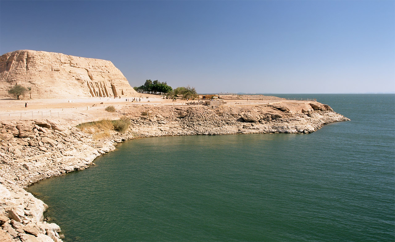
Abu Simbel entered the World Heritage List in 1979 as part of the ten-component serial property Nubian Monuments from Abu Simbel to Philae. The designation takes in more than the two Ramesside temples and more than the dam-rescue episode. That broader framework can help keep temples, later sites and relocated monuments in view without calling Abu Simbel a separate UNESCO listing. It should also sharpen, rather than soften, the distinction between a spectacularly conserved carved façade and the riverbank world submerged beneath today's view. The site's architecture is both Ramesses' ancient experiment in royal scale and a twentieth-century experiment in moving stone: the strongest reading of the pair leaves neither story—and neither its people nor its hidden supports—out. [2][3][4][5][18]
Watch: Saving Abu Simbel
Official film and campaign records are linked at their source; previews are separately licensed photographs.
The World Saves Abu Simbel
UNESCO Archives · 1967 documentation of the stone-by-stone rescue; archive catalogue in several languages.
Editorial photograph: UNESCO, source; CC BY-SA 3.0 igo. Film footage and film thumbnails are not reproduced.Abu Simbel: the salvage begins
UNESCO Archives · a short silent 1965 campaign film record.
Editorial photograph: Archivio fotografico Museo Egizio, Turin, source; CC0. Film footage and film thumbnails are not reproduced.Working Together: Abu Simbel
UNESCO World Heritage Centre · a retrospective of the Egyptian/Sudanese-requested international campaign.
Editorial photograph: Przemyslaw “Blueshade” Idzkiewicz, source; CC BY-SA 2.0. Film footage and film thumbnails are not reproduced.Explore RELATED Artworks
Relief and sculpture records that clarify royal and Hathoric image programmes.
Qadesh royal relief
The carved king belongs to a larger, politically charged war programme.
Photo source · CC0Eight Osiride royal fronts
King-shaped supports carry far more than the hall’s roof.
Photo source · CC BY-SA 2.0Hathor-headed Small Temple hall
Queen and goddess imagery marks the inward route.
Photo source · CC BY-SA 4.0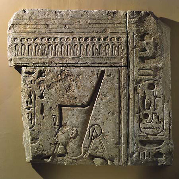
Jubilee Relief of Ramesses II
A comparative royal relief from Heracleopolis—not Abu Simbel.
The Met · Open AccessThe British Museum’s Papyrus Sallier III preserves a Qadesh Poem version, while its hawk-headed sandstone sphinx came from near Abu Simbel. Neither is a fragment of the Temple’s Qadesh wall. [16][17]
Frequently Asked Questions
No. The site contains Ramesses II’s Great Temple and a smaller northern rock-cut temple for Hathor of Ibshek and Nefertari. [1] [6] [13]
No. Ancient carved blocks were reassembled in a new artificial hill with concrete supports and protective domes above Lake Nasser. [3] [5]
Four seated king figures were carved. One fell after an ancient earthquake and its pieces still lie below the facade. [1] [5] [13]
Two queen colossi stand with four of Ramesses. Their heights are comparable, but the total allocation is four-to-two. [1] [6]
No. Modern late-February and late-October dawn light reaches Amun-Ra, deified Ramesses and Ra-Horakhty; Ptah remains dark. [1] [10]
No. February and October are not the equinoxes, and no secure ancient evidence identifies the dates as Ramesses’ birth and coronation anniversaries. [1] [10]
No. It is a royal claim in an Egyptian court programme. The military outcome is disputed in wider scholarship. [13] [24]
The Aswan High Dam reservoir threatened their low Nile-bank position. An Egyptian- and Sudanese-requested international campaign cut and raised the temples. [3] [4] [5]
The original engineer specifies 208 metres north-west, the Great Temple 65 metres higher and the Small Temple 67 metres higher. UNESCO’s retrospective uses rounded figures of about 180 metres inland and 64 metres higher. [3] [5]
No. It belongs to the ten-component World Heritage property Nubian Monuments from Abu Simbel to Philae, inscribed in 1979. [2]
References
- Egyptian Ministry of Tourism and Antiquities, Abu Simbel monument record and Arabic entry. View source
- UNESCO World Heritage Centre, Nubian Monuments from Abu Simbel to Philae. View source
- UNESCO World Heritage Centre, Working Together: Abu Simbel and French campaign account. View source
- UNESCO World Heritage Centre, The International Campaign to Save the Monuments of Nubia. View source
- Lennart Berg, “The Salvage of the Abu Simbel Temples,” Monumentum 17, original engineering account. View source
- Edward Scrivens, Goddesses in Ramessid Egypt, University of Oxford doctoral thesis, Abu Simbel case study. View source
- Christiane Leblanc, Henuttawy at Abu Simbel, BIFAO 86, French archaeological record. View source
- IFAO, Nineteenth-Dynasty royal statuary catalogue, Hathor-cow sanctuary record. View source
- CEDAE/Association pour la Sauvegarde du Ramesseum, Abou Simbel — Les piliers osiriaques, publisher's scholarly-volume description. View source
- Mosalam Shaltout and Juan Antonio Belmonte, Egyptian–Spanish archaeoastronomy survey, university-hosted field paper. View source
- Egyptian National Research Institute of Astronomy and Geophysics, Abu Simbel geomatics study abstract, 2023. View source
- UNESCO Multimedia Archives, The World Saves Abu Simbel, 1967 film catalogue. View source
- Khaled el-Enany, Arabic Abu Simbel temple guide, CEDAE/Association pour la Sauvegarde du Ramesseum. View source
- Patricia Usick, William John Bankes' Collection of Drawings and Manuscripts Relating to Ancient Nubia, University College London doctoral thesis, vols. I–II. View source
- Diana Espada Torres, Spanish study of Abu Simbel in nineteenth-century sources, University of Zaragoza repository. View source
- British Museum, Papyrus Sallier III object record. View source
- British Museum, sandstone hawk-headed sphinx from Abu Simbel. View source
- University of Michigan, Narrating Nubia: displacement and memory, collaborative exhibition. View source
- Fayrouz Kaddal, On Displacement and Music, American University in Cairo thesis record. View source
- Christine Gilmore, Nubian post-dam literary narratives, University of Leeds dissertation record. View source
- UNESCO Multimedia Archives, Abu Simbel: the salvage begins, 1965 film catalogue. View source
- AUC Press, Nigel Fletcher-Jones, Abu Simbel and the Nubian Temples, publisher's description. View source
- Metropolitan Museum of Art, Jubilee Relief of Ramesses II, object record. View source
- ARCE, Dr Betsy Bryan's Qadesh lecture record, Johns Hopkins University scholar. View source
- University of Chicago ISAC Epigraphic Survey, Chicago House Bulletin Abu Simbel visit, 1996. View source