


 by Tom Gurney
Tom Gurney BSc (Hons) is an art history expert with over 20 years experience
Email: tomgurney1@gmail.com / Phone: +44 7429 011000
Beyond Angkor Wat: Reading Khmer Architecture through Cities, Water and Living History
Khmer architecture cannot be reduced to Angkor Wat or to a civilisation that disappeared with its court. It includes brick sanctuaries, sandstone temples, reservoirs, canals, roads, bridges, hospitals, palaces known through archaeology, timber houses, Buddhist monasteries, colonial buildings and modern Cambodian cities. Many places remain active religious or residential landscapes under Cambodian authority.
The best-known monuments were produced across different reigns, capitals and institutions. Their towers, galleries and carvings are visible because stone survived; roofs, houses, markets and service buildings made from timber, thatch and earth are much less complete. A balanced history combines monuments with inscriptions, excavation, environmental evidence and living use.
Terminology must stay dated. Getty vocabularies help coordinate names for rulers, places, religions and archaeological periods, but an English index term does not settle Khmer meanings or ownership [1]. “Pre-Angkorian,” “Angkorian” and “post-Angkor” are useful chronological frames, not value rankings.
Contents
Khmer building history begins before Angkor
Sambor Prei Kuk is associated with Ishanapura, a capital that flourished in the late sixth and early seventh centuries. Its temple zone contains brick sanctuaries, including unusual octagonal buildings, with sandstone door frames, lintels and other details. Inscriptions in Sanskrit and Old Khmer name rulers, religious foundations and activities [2].
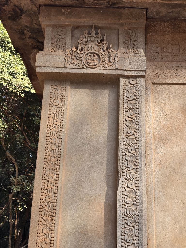
The sandstone doorway of Prasat Asram Maha Rusei at Sambor Prei Kuk, photographed by Ms Sarah Welch in January 2025. Carved bands, wall panels and damage make material assembly and later change visible beside the site's better-known brick sanctuaries. Ms Sarah Welch, Prasat Asram Maha Rusei at Sambor Prei Kuk; CC0. JPEG prepared; no crop or retouch.
The site also preserves causeways, enclosures, water features and buried archaeological layers. These connect religious buildings to an urban and managed landscape. Later Angkorian forms did not emerge without precedent, yet Sambor Prei Kuk should not be valued only as preparation for something later.
Brick and sandstone behaved differently
Fired brick could form walls and corbelled roofs, sometimes bonded and finished so tightly that joints appear slight. Sandstone was used for frames, thresholds, sculpture and structural members requiring different cutting. Laterite, an iron-rich material that hardens after quarrying, commonly served in foundations, walls and cores.
Timber completed many roofs, doors, ceilings and ordinary structures but rarely survives from early periods. Missing wood can make a stone sanctuary look more isolated and austere than it was in use.
Capitals moved with political projects
Khmer rulers did not occupy one unchanging centre. Hariharalaya in the Roluos area, Angkor, Koh Ker and other locations became focuses at different times. Moving a court redirected quarrying, water management, ritual foundations, roads and labour.
Koh Ker was a rival and then sole capital under Jayavarman IV between 921 and 944. Its short construction period produced a large sacred urban ensemble, inscriptions, hydraulic features and experiments with massive stone blocks [3]. This is evidence of concentrated political ambition, not an incomplete copy of Angkor.
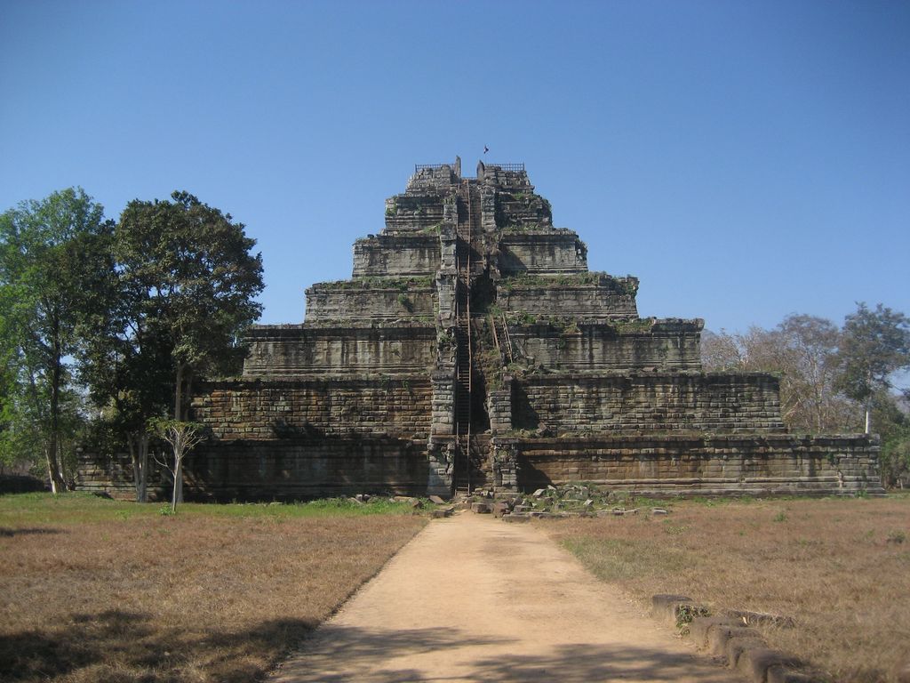
The stepped Prang behind Prasat Thom at Koh Ker, photographed by Arian Zwegers in January 2008. Its concentrated scale belongs to Jayavarman IV's tenth-century capital, a wider sacred and hydraulic landscape beyond the monument. Arian Zwegers, Koh Ker, Prasat Thom; CC BY 2.0. JPEG prepared; no crop or retouch.
Preah Vihear made topography part of approach
The Temple of Preah Vihear occupies the edge of the Dangrek plateau. Sanctuaries, stairs and pavements extend along an approximately 800-metre route shaped by the rising site. Its main eleventh-century work was dedicated to Shiva, with earlier foundations and later alteration [5].
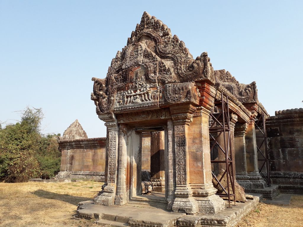
A gopura at Preah Vihear, photographed by GRANDE PUFFO VCO in February 2019. Carved sandstone, rising approach and visible bracing belong to a long temple route shaped by the Dangrek plateau and present conservation. GRANDE PUFFO VCO, Preah Vihear: Gopura IV doorway and pediment; CC0. JPEG prepared; no crop or retouch.
The border setting has made management politically sensitive. Architectural interpretation should distinguish the temple's Khmer history and Cambodian stewardship from modern territorial narratives. Topography, access and sight lines are part of its design, not merely a scenic background.
Angkor was an inhabited region
The Angkor World Heritage property covers far more than temple compounds. It contains successive capitals, reservoirs, embankments, canals, roads, neighbourhood traces and agricultural land across a large area [4]. Stone monuments were nodes within settlement and production systems.
Archaeology has identified occupation mounds, ponds and route networks beyond monumental cores. Houses and workshops were often timber and organic material, so their absence above ground does not imply an empty ceremonial city. The court depended on farmers, fishers, quarry workers, transport crews, artisans, ritual specialists and administrators.
Angkor Wat served a specific royal programme
Angkor Wat was constructed in the first half of the twelfth century under Suryavarman II and was originally associated with Vishnu. Moats, causeways, enclosures, galleries and elevated sanctuaries organise a long sequence of approach. Bas-reliefs connect epic narratives, divine imagery and royal power [16].
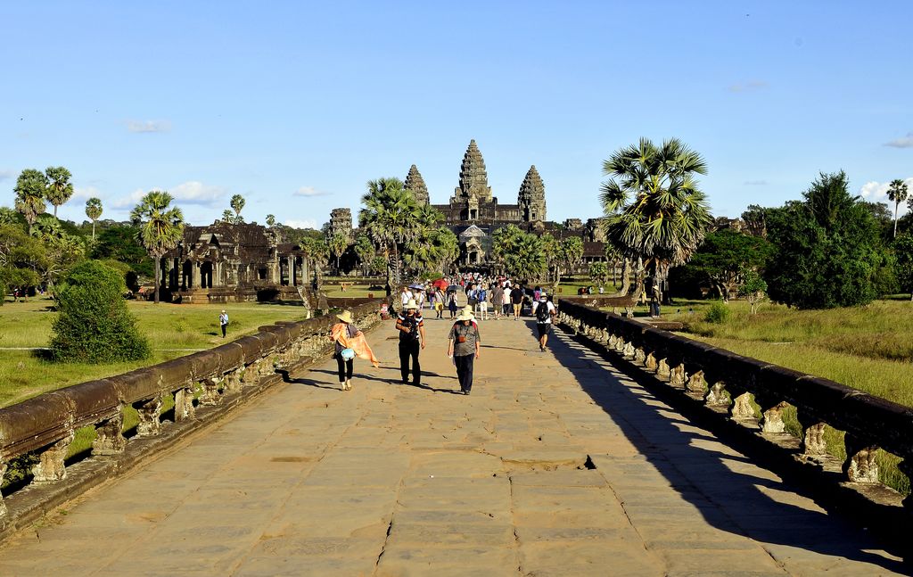
Angkor Wat from the western causeway, photographed by LBM1948 in December 2014. Causeway, balustrades, enclosures and towers organise a long royal and sacred approach within a much larger inhabited and hydraulic region. LBM1948, Angkor Wat, western causeway; CC BY-SA 4.0. JPEG prepared; no crop or retouch.
Later Buddhist use and continuing care are part of the monument's biography. Calling it simply a Hindu temple freezes one moment; calling every Khmer sanctuary “like Angkor Wat” erases differing plans, dedications and dates. The broader Hindu temple architecture guide explains transregional religious concepts without taking Cambodian authorship away.
Religious identities changed over time
Khmer courts supported forms of Shaivism, Vaishnavism, Mahayana Buddhism and later Theravada Buddhism in different combinations. A building could be rededicated, its images removed or replaced, and its spaces reused. Present classification must therefore follow the dated evidence.
Bayon stood at the centre of Angkor Thom under Jayavarman VII in the late twelfth and early thirteenth centuries. Its face towers, galleries and imagery belong to a Mahayana Buddhist state programme, while later Hindu alteration is also visible [17]. The famous faces should not detach the temple from its urban, ritual and political setting.
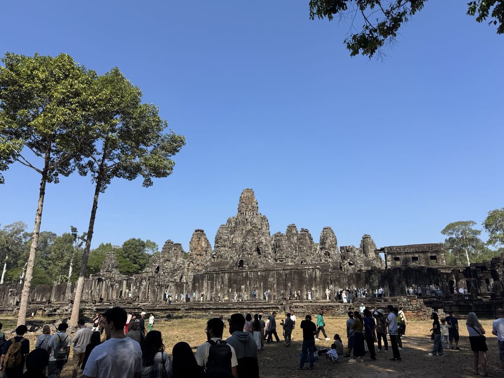
Bayon at the centre of Angkor Thom, photographed by KhalidAlzeyoudi in January 2025. Face towers and galleries belong to Jayavarman VII's Mahayana Buddhist programme, later religious alteration and a heavily visited urban monument. KhalidAlzeyoudi, Bayon Temple exterior; CC0. JPEG prepared; no crop or retouch.
Monasteries kept sites in use
Theravada Buddhist communities occupied and cared for many Angkorian places after royal patronage changed. Timber halls, monks' residences, stupas and village facilities may sit near much older stone fabric. These layers complicate archaeological efforts to privilege one construction phase.
Religious owners and local residents are not obstacles to an ancient site. Their practice is part of its history. Conservation must negotiate worship, access and safety while protecting fragile material.
Stone temples were assembled systems
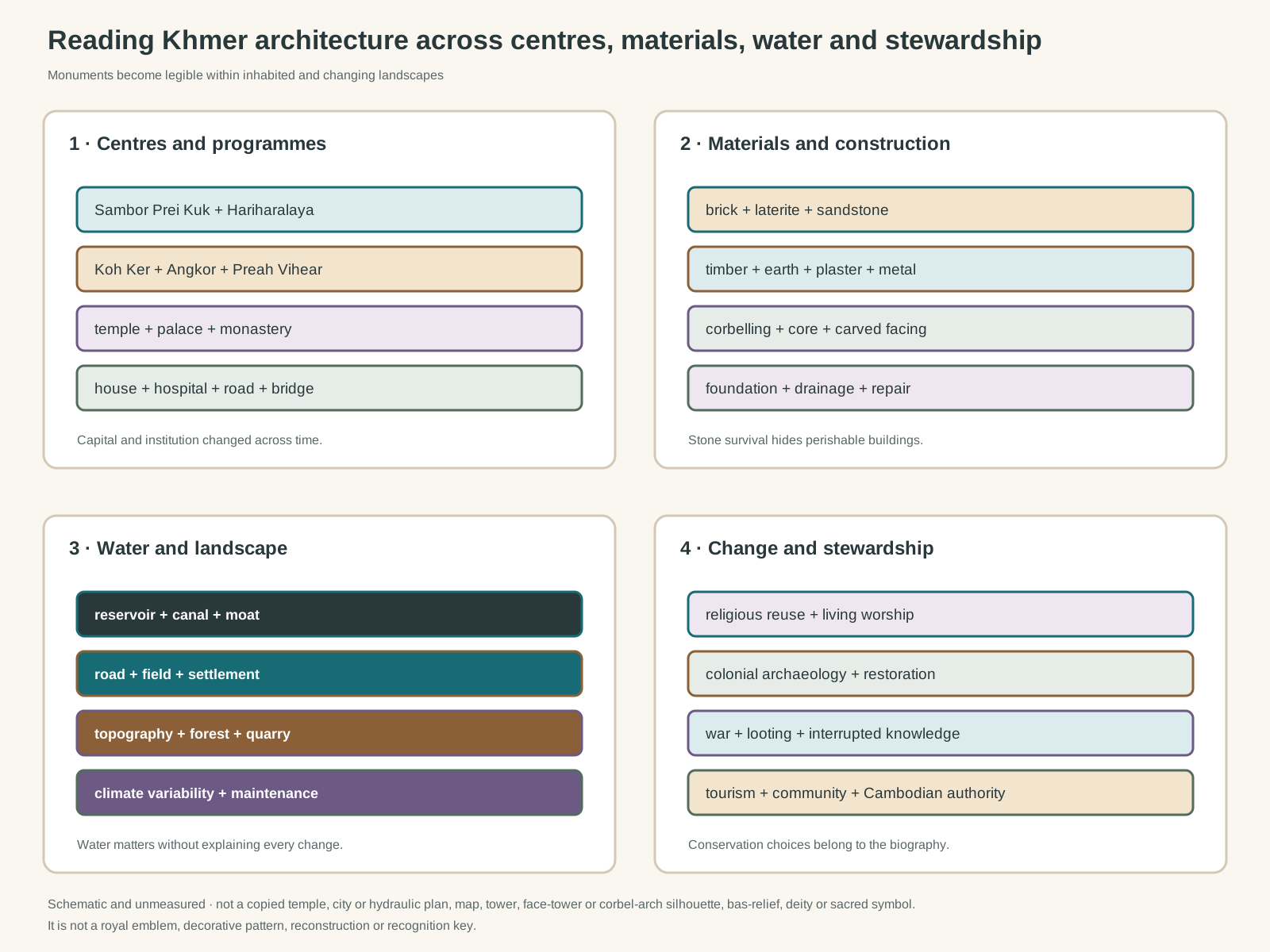
Original unmeasured evidence diagram. It is not a copied temple, city or hydraulic plan, map, tower, face-tower or corbel-arch silhouette, bas-relief, deity, sacred symbol, royal emblem, decorative pattern, reconstruction or visual identification key.
Text alternative for the diagram
The diagram distinguishes changing capitals, temples, palaces, monasteries, houses and infrastructure; brick, laterite, sandstone, timber, earth and drainage; reservoirs, roads, farms and settlements; and reuse, colonial archaeology, war, tourism, climate and Cambodian stewardship.
Sandstone blocks were quarried, shaped, transported and set in carefully sequenced courses. Laterite often created foundations or internal mass. Corbelled vaults form when successive masonry courses project inward until they meet; they transfer loads differently from a true arch and impose limits on span.
Walls, galleries and towers need drainage because water entering joints can wash fill, corrode metal and destabilise foundations. Roof stones are heavy, while tropical vegetation can prise masonry apart. The apparent permanence of stone depends on continuing water control and repair.
Construction involved many kinds of maker
Royal inscriptions foreground patrons, but officials organised supplies and labour. Quarry workers, boat crews, carters, masons, sculptors, carpenters and metalworkers transformed materials. Agricultural households supported projects through production and obligations whose precise organisation varied.
The Metropolitan Museum's Southeast Asian material provides comparative evidence for Khmer stone and bronze production and regional religious imagery [18]. Portable sculpture helps reconstruct patronage and ritual, but objects removed from their architectural setting need provenance and original-location evidence.
Water shaped life without explaining everything
Angkor's large reservoirs, canals, moats and embankments stored, directed and redistributed water. They supported settlement, agriculture, transport, ritual and flood management in changing combinations. Some features were rebuilt or repurposed as political centres shifted.
It is misleading to claim that one failed hydraulic system caused Angkor's transformation. Climate variability, maintenance, political change, trade routes and movement of populations interacted. Water evidence can reveal stress and adaptation without becoming a single-cause collapse story.
APSARA treats forest, vegetation and water as components of the Angkor cultural landscape and manages them alongside monuments [10]. Current drainage is also a conservation tool: standing water and uncontrolled runoff can undermine ancient structures.
Roads and bridges connected a wider territory
Royal roads linked Angkor to provincial centres, with bridges, rest houses and hospitals supporting movement. Laterite and sandstone bridges sometimes continue to carry local traffic. Their durable arches and piers are infrastructure, not decorative extensions of temples.
Settlements along these routes participated in regional economies and religious networks. Khmer architectural history therefore extends beyond present park boundaries and the monumental capital.
Regional exchange had several directions
Khmer building developed through relationships with South and Southeast Asia. Religious ideas and texts arrived from India through intermediaries, but builders created local structures rather than reproducing Indian buildings. Contacts with Champa, Java, Lao regions and Siam involved diplomacy, warfare, migration and skilled work.
Vat Phou in present Laos has a long sacred landscape associated with a mountain, water and route systems; its Khmer-period buildings connect the Mekong region to wider political centres [6]. My Son in present Vietnam belongs to Cham history and preserves its own brick temple traditions [7]. Comparison should protect those owners rather than relabel them as peripheral Khmer works.
Ayutthaya later transformed architectural and administrative ideas within a Thai kingdom [8]. Similar forms can result from shared religious concepts or direct contact, but neither proves that one culture merely copied another. Dates, routes and agents matter.
Palaces and houses survive indirectly
Royal palaces at Angkor were largely built in perishable materials within walled precincts. Postholes, terraces, ponds, ceramics and written accounts reveal their scale and use. Stone gates and enclosure walls should not be mistaken for the complete palace architecture.
Ordinary Khmer houses continue timber and raised-floor practices adapted to flooding, ventilation and household work. Historic forms changed with forestry, markets, concrete, metal roofing and family needs. They should not be presented as living fossils of Angkor.
Raised floors create shaded work and storage areas while helping living spaces cope with seasonal water. Stairs, verandas, wall panels and roof openings mediate access and airflow. These recurring responses still vary between floodplain, lakeside, urban and upland settings. Household architecture also records cooking, craft, livestock and kinship, subjects that royal inscriptions rarely describe.
Markets and monasteries formed additional everyday centres. Timber stalls, roads, landing places and community halls could be rebuilt many times, leaving continuities of location and use rather than early material. Archaeological sampling and oral history are therefore important companions to stone-focused surveys.
The National Museum of Cambodia holds architectural fragments and sculpture transferred for protection, study or display [19]. Museum care can reduce theft and weather exposure while making the original site relationship less immediate. Provenance records reconnect object and building.
Colonial archaeology shaped what visitors see
French colonial institutions organised extensive clearance, recording and restoration at Angkor. The École française d'Extrême-Orient developed archives and used anastylosis, a method of dismantling and reassembling fallen masonry after documentation [15]. This produced vital knowledge while operating inside colonial power structures.
The Baphuon restoration demonstrates the difficulty. The temple's unstable sand-filled structure was dismantled in parts before war interrupted work and scattered records; later teams reconstructed an enormous three-dimensional puzzle using surviving documentation and blocks [14]. Concrete and resin were introduced selectively alongside laterite and sandstone.
Restoration is therefore not invisible recovery. Each campaign makes choices about structural stability, replaced stones, religious layers and visitor access. Those decisions should be documented as part of the monument.
War damaged people, knowledge and buildings
Conflict from the late 1960s through the 1990s interrupted conservation, killed and displaced Cambodian professionals and communities, and exposed sites to landmines, looting and illicit trade. The architectural consequence was not limited to chipped stone; institutions and chains of knowledge were broken.
The Documentation Center of Cambodia preserves records of the Khmer Rouge period and its human consequences [24]. Architectural history must approach this evidence through affected people rather than using ruins as dramatic scenery.
After Angkor entered the World Heritage List in 1992, international coordination helped mobilise expertise and funding under Cambodian state authority [13]. Emergency conditions did not remove questions about who sets priorities or benefits from tourism.
Conservation now includes communities and climate
APSARA National Authority manages Angkor's heritage, environment and development context [9]. Its framework connects zoning, archaeology, water, forest, tourism and resident communities [11]. This broad mandate recognises that protecting one temple while destabilising surrounding livelihoods is not sustainable.
UNESCO monitoring records risks from development proposals, visitor pressure, water, infrastructure and management [12]. Conservation groups contribute specialised repair and training: World Monuments Fund has worked at several Angkor sites [20], while Banteay Chhmar projects have connected structural conservation with local participation [21].
Tourism creates resources and pressure
Ticket income and employment can support heritage, but heavy footfall wears stairs and galleries, while simplified itineraries crowd a few monuments. Hotels, roads and groundwater use affect the wider Siem Reap landscape. Visitor management is architectural planning.
Access decisions also carry social consequences. Paths, barriers, ticket zones and transport hubs determine which residents can reach fields, shrines and work. Conservation plans need transparent consultation, fair compensation where movement changes and evidence about how communities use the landscape. Treating local occupation as visual intrusion can reproduce colonial assumptions about an empty archaeological park.
Climate change intensifies rainfall extremes, heat and biological growth. Monitoring foundations, drainage and tree stability is as important as cleaning carved surfaces. Flood and drought preparation must serve residents as well as monuments.
Watch: Khmer Architecture through Angkor Wat and Structural Reading
Begin with Angkor Wat as an assembled stone system, then widen the view to routes, enclosure, water and surface without detaching the monument from Khmer makers and Cambodian stewardship.
How Is Angkor Wat Still Standing Today?
A concise structural account focuses on how Angkor Wat's sandstone blocks, joints and foundations were assembled, providing a useful starting point for testing durability against repair and environmental history.
Watch on YouTubeModern Cambodian architecture also belongs here
Twentieth-century Cambodian architects designed schools, housing, markets, theatres, civic complexes and sports facilities using concrete, brick and climate-responsive ventilation. Modern work engaged international ideas while answering local programmes and construction economies.
Deep overhangs, screens, courtyards and shaded circulation could temper heat while reinforced concrete enabled wider spans and new civic programmes. These were modern technical choices rather than direct copies of Angkorian forms. Some commissions nevertheless used proportional, landscape or ceremonial references to negotiate national identity after independence.
War, neglect and rapid redevelopment have endangered this recent heritage. The Royal University of Fine Arts trains Cambodian architects and conservators whose professional authority connects ancient-site work with present cities [23]. Khmer architecture did not stop when royal building shifted away from Angkor.
Broad scholarship on Angkor now joins inscriptions and monuments with settlement archaeology, agriculture and environmental change [22]. That expansion makes the past more complex and also more relevant to Cambodian planning today.
How to read Khmer architecture
Start with the centre and date: Sambor Prei Kuk, Koh Ker, Angkor, Preah Vihear or another place. Identify the patron and institution, then distinguish initial dedication from later reuse.
Trace materials from quarry or forest to structure. Separate sandstone skin, laterite core, brick wall, timber roof and earthen platform. Look for drainage, replaced blocks, conservation anchors and missing perishable buildings.
Finally widen the view to reservoirs, roads, fields, villages, labour and modern governance. This method respects monumental achievement without pretending that temples were the whole Khmer built environment.
Khmer Architecture: Five Evidence Tests
Begin with a dated centre and institution, then connect material assembly to route, water, regional exchange, later use and Cambodian stewardship.
| Evidence | What it can establish | What else to verify |
|---|---|---|
| Centre and institution | Capital, sanctuary, monastery, palace, house, hospital and infrastructure organise distinct spaces. | Angkor Wat cannot represent every Khmer building or period. |
| Material assembly | Brick, sandstone, laterite, timber, earth and metal reveal construction choices. | Separate surviving stone from missing roofs, doors and ordinary buildings. |
| Route and water | Causeways, galleries, roads, bridges, reservoirs and canals shape use and settlement. | Water management matters without explaining every political change. |
| Religion and exchange | Hindu, Mahayana and Theravada histories changed through locally authored regional networks. | Initial dedication does not erase later worship or Cambodian authority. |
| Afterlife and stewardship | Colonial archaeology, war, repair, tourism, climate and living use shape present fabric. | Identify residents, monastics, conservators and APSARA authority. |
Frequently Asked Questions
No. Angkor Wat is one major twelfth-century complex within a much longer history of cities, sanctuaries, infrastructure, houses and modern buildings.
No. Dedications changed across Shaiva, Vaishnava, Mahayana and Theravada Buddhist settings, and individual buildings could be reused.
No single mechanism explains the political and demographic shifts. Water stress interacted with climate, maintenance, trade and political change.
It is an iron-rich material quarried while workable and hardened on exposure. Khmer builders commonly used it in foundations, cores and enclosure walls.
Many stone roofs and openings use corbelling, where courses project inward. This is structurally different from a voussoir arch.
Palatial and domestic buildings often relied on timber and other perishable materials, while religious stonework survived more readily.
No. The region contains active monasteries, villages, farms, tourism and heritage institutions, with long histories of continued use.
APSARA National Authority leads Cambodian management, working with communities, other national bodies and coordinated international partners.
Discussion
Which Khmer building or landscape most clearly shows why centre, institution, material, water and later history must be read together?
Reader Insights
Which place, period, institution and community make the example historically specific?
How do stone and lost timber, enclosure, causeway, gallery, water, settlement and topography work together?
What changed through religious reuse, colonial archaeology, war, repair, tourism, climate or continuing worship, and which Cambodian communities and authorities shape interpretation now?
Join the Conversation
Share a documented Khmer example below, noting its place, patron, institution, materials, date, regional routes, later uses and evidence limits.
References
- Getty Research Institute, “Getty Vocabularies,” View source
- UNESCO World Heritage Centre, “Temple Zone of Sambor Prei Kuk,” View source
- UNESCO World Heritage Centre, “Koh Ker: Archaeological Site of Ancient Lingapura or Chok Gargyar,” View source
- UNESCO World Heritage Centre, “Angkor,” View source
- UNESCO World Heritage Centre, “Temple of Preah Vihear,” View source
- UNESCO World Heritage Centre, “Vat Phou and Associated Ancient Settlements within the Champasak Cultural Landscape,” View source
- UNESCO World Heritage Centre, “My Son Sanctuary,” View source
- UNESCO World Heritage Centre, “Historic City of Ayutthaya,” View source
- APSARA National Authority, “APSARA National Authority,” View source
- APSARA National Authority, “Environment, Water and Forestry Management,” View source
- APSARA National Authority, “Angkor Heritage Management Framework,” View source
- UNESCO World Heritage Centre, “State of Conservation: Angkor,” View source
- UNESCO, “International Coordination for the Safeguarding and Development of the Historic Site of Angkor,” View source
- École française d'Extrême-Orient, “Le Baphuon,” View source
- École française d'Extrême-Orient, “EFEO in Cambodia,” View source
- Smarthistory, “Angkor Wat,” View source
- Smarthistory, “The Bayon: A temple with many faces,” View source
- Metropolitan Museum of Art, “The Art of Southeast Asia: Cambodia and Vietnam,” View source
- National Museum of Cambodia, “National Museum of Cambodia,” View source
- World Monuments Fund, “Angkor Archaeological Park,” View source
- Global Heritage Fund, “Banteay Chhmar,” View source
- Yale University Press, “Angkor and the Khmer Civilization,” View source
- Royal University of Fine Arts Cambodia, “Faculty of Architecture and Urbanism,” View source
- Documentation Center of Cambodia, “Documentation Center of Cambodia,” View source