


 by Tom Gurney
Tom Gurney BSc (Hons) is an art history expert with over 20 years experience
Email: tomgurney1@gmail.com / Phone: +44 7429 011000
Beyond the Templo Mayor: Reading Mexica Architecture through Lake, Neighbourhood and Living City
Aztec architecture is a useful search term, but it needs explanation. “Aztec” can refer broadly to Nahuatl-speaking peoples associated with central Mexico in the centuries before the Spanish invasion. The rulers of Tenochtitlan called themselves Mexica, while neighbouring cities had distinct communities and political identities. Architecture makes more sense when those names replace a single undifferentiated label.
The subject is also living history. Nahua peoples are present across many Mexican states, including Mexico City, and their communities sustain diverse languages, institutions and cultural practices [2]. INALI records multiple national language varieties under the wider Nahuatl grouping [3]. Neither the fall of an imperial capital in 1521 nor the destruction of its central buildings marks the disappearance of Nahua people.
This guide therefore centres the Late Postclassic Basin of Mexico, especially the fourteenth to early sixteenth centuries, while carrying the story into colonial and modern Mexico City. Getty vocabularies can coordinate alternative names, yet local, Indigenous and national authorities remain responsible for identity and interpretation [1].
Contents
- The Basin Before Tenochtitlan
- Lake City
- Neighbourhood Life
- Sacred Precincts
- Orientation
- Material Systems
- Labour and Tribute
- Source Criticism
- Siege and Destruction
- Nahua Mexico City
- Recommended Books
- Watch Architecture
- Excavation in a Living City
- How to Read
- Evidence Tests
- Frequently Asked Questions
- Discussion
- References
The Basin had many cities before Tenochtitlan
Tenochtitlan rose within a densely settled lake basin shaped by earlier urban traditions. Teotihuacan had been a great metropolis centuries before, while Tula and numerous later centres supplied forms, histories and political models. Mexica rulers referred to older places selectively as they established their own legitimacy.
Around Lake Texcoco, communities organised themselves through altepetl: political and territorial entities often translated as city-states. Tenochtitlan, Texcoco and Tlacopan formed the Triple Alliance, but alliance did not erase each capital’s institutions. Tlatelolco occupied a neighbouring island settlement with a separate ruling history and a major market.
INAH dates Tlatelolco’s foundation to the fourteenth century and records its conquest by Tenochtitlan in 1473, while emphasising its continuing commercial importance [8]. A page about Aztec architecture must therefore be more than a plan of one sacred precinct.
“Aztec Empire” describes uneven power
The alliance extracted tribute and labour across a wide territory, but subject polities were not all rebuilt as copies of the capital. Some kept rulers and local architectural customs. Enemies such as Tlaxcala and the Purépecha state remained outside imperial control.
Cambridge’s synthesis of Mexico-Tenochtitlan connects the capital’s growth to resources and human effort drawn from a large hinterland [20]. That relationship should be stated directly: monumental construction records political command as well as technical skill.
Tenochtitlan was a lake city
The Mexica established Tenochtitlan on islands and shallows in Lake Texcoco. Builders enlarged inhabitable ground with fill, retaining edges and managed plots. Three principal causeways connected the city to shoreside routes, while openings and bridges preserved water passage and canoe traffic.
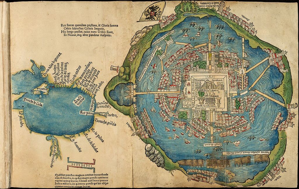
A hand-coloured woodcut of Tenochtitlan and the Gulf of Mexico published at Nuremberg in 1524, from the Newberry Library. Its circular island, canals, causeways and central precinct made the conquered capital legible to a European audience; the print is a political representation, not a measured city survey. Hernán Cortés (source attribution); Friedrich Peypus, printer, Map of Mexico City and the Gulf of Mexico; Public domain. JPEG prepared; no crop or retouch.
Canals carried people, food, stone, timber and market goods. Research on pre-conquest navigation identifies water routes as planned components of urban connection, not picturesque gaps between streets [16]. Land and water circulation worked together.
Fresh water required separate infrastructure because surrounding lake water was not uniformly drinkable. Aqueducts brought spring water from Chapultepec and later sources. Dikes and control works moderated floods and separated water conditions across the basin. UNAM engineering research combines these systems with sanitation practices and urban supply [14].
Chinampas were working landscapes
Chinampas are raised cultivation plots made through managed soil, organic matter, canals and boundaries in shallow lake environments. They supported food production, movement and settlement, particularly in southern basin zones. They were neither naturally floating islands nor a single invention of the Mexica state.
Household and cadastral evidence suggests that some urban residents held chinampa plots, while a city of Tenochtitlan’s scale relied on wider agricultural support [17]. The point is dependency and coordination, not ecological self-sufficiency.
UNESCO’s joint listing of Mexico City’s historic centre and Xochimilco recognises both Tenochtitlan’s urban legacy and the surviving chinampa landscape, while noting intense pressure from metropolitan growth [4]. Present growers and communities are part of that heritage.
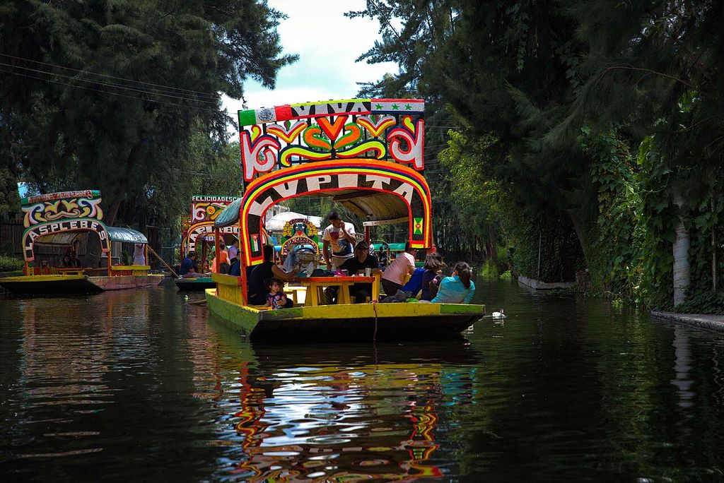
Modern tourist trajineras move along a Xochimilco canal in Rod Waddington's September 2016 photograph. The living waterway belongs to a metropolitan landscape where transport, tourism, vegetation, services and surviving chinampa cultivation now interact; the boats are not ancient reconstructions. Rod Waddington, Trajineras on a Xochimilco canal; CC BY-SA 2.0. JPEG prepared; no crop or retouch.
Streets, canals and neighbourhoods structured daily life
Tenochtitlan was divided into broad quarters and smaller neighbourhood units. The word calpulli can describe related territorial, social, economic and religious organisation, but scholars debate its precise form and variation. UNAM’s dedicated study places land, work, hierarchy and worship within that question [10].
Most residents did not live in palaces. Domestic compounds grouped rooms and work areas around patios, sometimes with gardens or water access. Earth, adobe, timber, reeds and plaster left less recoverable fabric than monumental stone. Workshops could be part of homes, making neighbourhoods centres of weaving, pottery, stone cutting, feather work and other production.
Archaeology beneath central Mexico City encounters fragments between colonial foundations, utilities and modern streets. UNAM’s urban-archaeology record shows how evidence for the principal precinct must be assembled from bounded interventions rather than exposed as a complete city [9].
Markets were civic architecture too
Tlatelolco’s market served the paired island cities and a much wider network. Its significance lay not only in a large open space but in routes, storage, oversight, standards and the continual movement of sellers and buyers. INAH’s account links the market to specialised long-distance merchants and a cosmopolitan population [8].
Schools, neighbourhood temples, administrative buildings and ballcourts added other forms of collective space. Their programmes varied. A building called a palace might join residence, audience, storage, tribute management and garden rather than functioning as a detached royal home.
Sacred precincts concentrated power and ritual
At the centre of Tenochtitlan, an enclosed precinct contained temples, shrines, schools, priestly buildings, a ballcourt and open gathering areas. It stood beside royal and administrative compounds. The Met’s survey places that precinct within the larger grid, canal network, markets and neighbourhoods [15].
The Templo Mayor, or Huey Teocalli, was the principal paired temple platform associated with Tlaloc and Huitzilopochtli. It was enlarged repeatedly. Each campaign partly or wholly covered earlier work, leaving nested stages that archaeologists can examine.
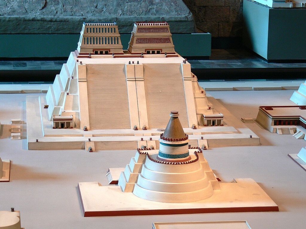
A reconstruction model of the Templo Mayor precinct in Mexico City's National Museum of Anthropology, photographed by Wolfgang Sauber in April 2008. The twin temple platform and neighbouring forms help visualise a vanished ensemble, but the model simplifies uncertain phases, materials, colour and superstructures. Wolfgang Sauber, Museum reconstruction model of the Templo Mayor precinct; CC BY-SA 3.0. JPEG prepared; no crop or retouch.
INAH’s Project Templo Mayor began after the 1978 discovery of the Coyolxauhqui monolith and expanded into continuing multidisciplinary research on the main temple and surrounding structures [5]. The archaeological zone is preserved and administered by Mexico’s INAH [6].
Rebuilding produced a stratified monument
Platform expansions required new fill, retaining masonry, stairs, plaster and summit structures. Builders had to control load and settlement on waterlogged ground. The latest pre-conquest fabric was heavily destroyed, so earlier buried phases can survive more substantially than the building encountered by Spaniards.
This reversal matters. The most visible archaeological stage is not automatically the final or most important one. INAH’s museum presents objects and architectural evidence from excavations while distinguishing modern exhibition choices from the ancient precinct [7].
Offerings placed within building stages help date construction and identify political or ritual programmes. They may include human remains and culturally sensitive material. Description should explain deposit, evidence and care without turning violence into entertainment.
Orientation claims need measurement
The Templo Mayor was connected to foundation histories, sacred mountains, agricultural cycles and the authority of its patrons. Such meanings do not license a claim that every street reproduced one cosmic diagram.
An archaeological study of the temple’s orientation compares historical narratives, horizon observations and measured alignment to generate testable hypotheses [19]. That method is more reliable than reading astronomical purpose from a modern reconstruction alone.
Similar-looking paired temples elsewhere may have different patrons or local histories. Tlatelolco’s main temple underwent its own stages within a distinct city. Form can show participation in regional practice without proving identical ownership.
Stone, earth and timber formed one system
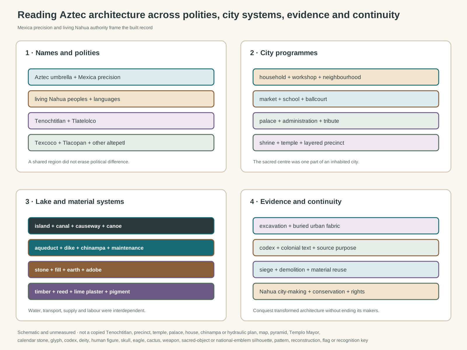
Original unmeasured evidence diagram. It is not a copied Tenochtitlan, precinct, temple, palace, house, chinampa or hydraulic plan; map; pyramid, Templo Mayor, calendar stone, glyph, codex, deity, human figure, skull, eagle, cactus, weapon, sacred object or national-emblem silhouette; decorative pattern; reconstruction; flag; or visual identification key.
Text alternative for the diagram
The diagram distinguishes Aztec, Mexica, Nahua and named altepetl; connects household, market, palace, school and sacred-precinct programmes; links islands, canals, causeways, water control, chinampas, stone, earth and timber; and separates archaeological, textual, museum, colonial and living-community evidence.
Tenochtitlan’s builders used volcanic stone including tezontle, denser stones for dressed or carved work, earth and rubble for fills, adobe for walls, lime plaster for surfaces, and timber for lintels and roofs. Reeds and other lake materials entered lighter structures and temporary work.
Tezontle is porous and comparatively light, useful where large volumes added load to soft ground. INAH research follows stone from quarries through transport and specialist cutting, showing that material choice depended on labour and tribute networks [11]. Stone was not simply available beside every site.
Timber choice was technical knowledge
Wooden members rarely survive as completely as stone platforms. Analysis of Tlatelolco lintels nevertheless shows that builders selected species for hardness, weight, workability, drying and resistance to decay or insects [12]. “Timber roof” therefore conceals careful procurement.
Lime plaster sealed floors, gave masonry a finished surface and received colour. Pigments made precincts visually different from today’s exposed stone. Maintenance demanded recoating, drainage clearance and replacement of vulnerable roof fabric.
INAH’s study of Tlatelolco urbanism records adjustments in lake-ground construction and helps resist the idea that one abstract “lacustrine architecture” solved every foundation problem [13]. Each phase responds to its existing platform, water and material supply.
Construction mobilised people and tribute
Rulers sponsored major works and named dedications, but quarry workers, carriers, masons, plasterers, carpenters, painters and food producers made them possible. Neighbourhood obligations, specialist service and tribute from subject communities could overlap.
Ancient Mesoamerica’s research overview connects Aztec urban design to political legitimation while also describing house workshops, patios and neighbourhood organisation [18]. Architecture carried imperial claims, yet its makers lived throughout the city.
Women’s labour is less often named in monumental inscriptions or Spanish military reports, but households, markets, textile production and food supply depended on it. A labour history must look beyond patrons even when individual biographies are unavailable.
Transport was an architectural condition. Canoes could move bulky material through canals, while causeways connected land routes. Quarry distance, vessel capacity, bridge openings and unloading places affected construction sequence.
Sources show different cities
Much of Tenochtitlan lies below later Mexico City. Archaeology supplies walls, fills, floors, drains, offerings and material sequences, but rarely a complete standing elevation. Written and pictorial sources fill some gaps while introducing their own purposes.
Cortés’s letters promoted his actions to the Spanish king. The printed plan accompanying their early publication is a European representation, not a measured survey [21]. Descriptions by conquerors may express admiration while justifying seizure.
Indigenous and Indigenous-colonial manuscripts preserve place signs, land, genealogy, tribute and civic claims. The Codex Quetzalecatzin, for example, combines Nahua pictorial conventions with signs of colonial adaptation and records family landholding in a specific region [22]. It is not a generic plan of Aztec life.
Names carry the history of collecting
Objects removed from buildings can lose deposit, orientation and association. Museum catalogues should record excavation, acquisition and uncertainty. The British Museum’s work with Indigenous researchers demonstrates how inherited labels and conquest narratives can be reconsidered [23].
This matters for the word “Aztec” itself. A collection category may group Mexica, central Mexican or Nahua works for convenience while obscuring a known place or community. Precise captions should keep both searchable terminology and better evidence.
The siege destroyed an inhabited city
In 1519, Spaniards entered a capital already embedded in rivalries and tribute relationships. The war that followed involved many Indigenous allies opposed to Mexica power, not a simple contest between two isolated peoples. Smallpox, disrupted supplies and violence devastated residents.
During the 1521 siege, attacks on causeways, canals, buildings and water infrastructure were strategies against the city itself. After surrender, conquerors demolished the principal precinct and reused stone. Mexico City became the colonial capital over and through the damaged island settlement.
Calling this an inevitable victory hides choices, alliances and coercion. Calling it the end of Indigenous architecture hides the Nahua builders, patrons and residents who continued to shape streets, waterworks, houses, chapels and government buildings.
Mexico City continued through Nahua work
Colonial authorities imposed Christian institutions and Spanish government, while Indigenous communities defended land, organised labour and maintained civic identities. Familiar materials such as tezontle continued in new structural systems. Canals and causeways remained important even as the lake environment was increasingly drained.
Barbara Mundy’s study, catalogued by the Smithsonian, foregrounds Nahua people in the making and ceremonial life of sixteenth-century Mexico City [24]. This approach replaces a clean break with contested transformation.
Tlatelolco makes those layers especially visible. The archaeological precinct, colonial church and college, modern housing and twentieth-century histories occupy one district. Conservation cannot select one date and treat everything later as intrusion.
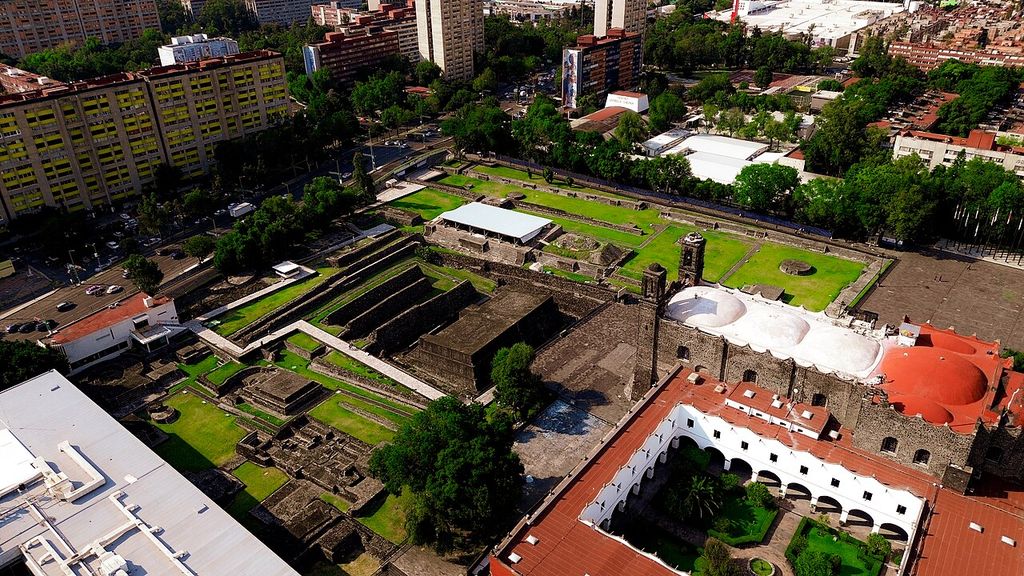
The Tlatelolco archaeological zone, Church and former monastery of Santiago, roads and modern housing share one urban field in ProtoplasmaKid's October 2023 aerial view. The image records successive institutions and uses rather than three sealed historical periods. ProtoplasmaKid, Aerial view of the Tlatelolco Archaeological Zone; CC BY-SA 4.0. JPEG prepared; no crop or retouch.
Water decisions have long consequences
Colonial and modern drainage works altered the basin at enormous scale. Aquifer extraction now contributes to subsidence, while surviving chinampa areas face pollution, land conversion and changing water supply. Ancient infrastructure is relevant history, not a ready-made engineering solution for the modern metropolis.
UNESCO’s conservation record joins archaeological fabric, historic urban form and Xochimilco’s continuing landscape [4]. Managing them requires residents, growers, water specialists, Indigenous communities and public authorities, not archaeology alone.
Watch: Tenochtitlan as Lake City and Architectural System
Begin with Tenochtitlan’s lake, causeways and canals, then widen the view to structure, enclosure and movement without reducing Mexica architecture to the Templo Mayor or treating reconstruction as measured fact.
Tenochtitlan: The Venice of Mesoamerica
This illustrated overview focuses on Tenochtitlan's island setting, causeways, canals and political rise. Use it with the page's source-critical cautions: the city belonged to a larger basin, modern reconstructions remain interpretive, and conquest did not end Nahua city-making.
Watch on YouTubeExcavation happens beneath a living metropolis
Utility work and redevelopment can expose walls or deposits unexpectedly. Rescue archaeology documents material before construction proceeds, but time and access constrain interpretation. Open excavation may also change moisture, temperature and structural support.
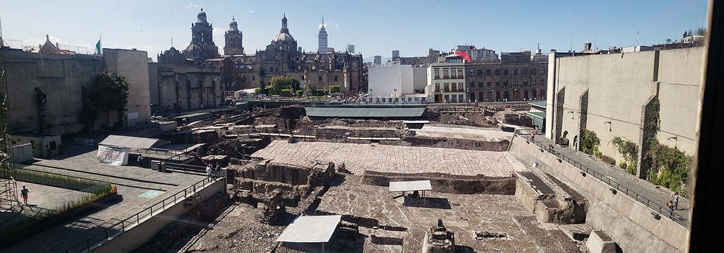
Excavated Templo Mayor walls and platforms lie among the buildings of Mexico City's historic centre in Minerva Castro's December 2018 panorama. Visitor walks, retaining structures and the Metropolitan Cathedral make visible an archaeological site managed within a continuously inhabited city. Minerva Castro, Templo Mayor archaeological zone in Mexico City's historic centre; CC BY-SA 4.0. JPEG prepared; no crop or retouch.
The Templo Mayor museum protects excavated objects and makes research public, while its own 1987 building belongs to a modern architectural and museological history [7]. Displays should explain when fragments were moved, restored or reconstructed.
Tourism concentrates visitors around dramatic ritual evidence. Responsible interpretation also includes water, labour, houses, markets and colonial continuity. Sacred objects and human remains need culturally informed policies for study, storage, display and possible return.
Living authority is not symbolic consultation
INPI’s national catalogue treats Indigenous communities as public-law subjects with rights to self-determination, rather than as folklore attached to archaeological sites [2]. Nahua communities are internally diverse; one representative cannot speak for every place.
Language is architectural evidence when names identify neighbourhoods, materials, offices and land relationships. Maintaining Nahuatl terms can preserve distinctions lost in English, provided spelling, variety and source are stated.
Collections outside Mexico raise questions about lawful export, provenance and interpretive control. Collaboration can improve names and context, but it does not erase acquisition history. Digital access is useful only when it respects restrictions around sensitive material.
How to read Aztec architecture
Begin by asking which people and city made the place. Mexica Tenochtitlan, Mexica Tlatelolco, Acolhua Texcoco and other altepetl shared a region without becoming interchangeable. State the date and political relationship.
Next locate the building within its working systems. Follow canal or street access, ground conditions, water supply, adjacent households and markets. Trace fill, stone, adobe, timber, plaster, pigment, drainage and later repair separately.
Finally identify the evidence. Excavated masonry, colonial description, codex image, museum object and modern model answer different questions. Record destruction and reconstruction rather than presenting a seamless view. Give living Nahua, site, national and scholarly authorities their proper roles.
Mexica and Aztec Architecture: Five Evidence Tests
Begin with the basin, city and named community, then connect water, neighbourhood and programme to material labour, source type, conquest and continuing urban life.
| Evidence | What it can establish | What else to verify |
|---|---|---|
| Basin and polity | Mexico-Tenochtitlan belonged to a lake basin of older cities and the Triple Alliance. | “Aztec” must not erase Mexica, Texcocan, Tlacopan or other Nahua identities. |
| Water and neighbourhood | Canals, causeways, aqueducts, chinampas, streets and wards organised movement and daily work. | Modern Xochimilco is a living landscape, not an unchanged ancient survival. |
| Programme and construction | House, market, palace, temple, platform and hydraulic works mobilised different materials and labour. | A precinct reconstruction cannot stand for the whole inhabited city. |
| Source type | Excavation, Nahua-language text, pictorial manuscript and Spanish account preserve different evidence. | Identify date, audience, translation, political purpose and uncertainty. |
| Conquest and continuity | Siege, demolition, material reuse, colonial building and modern excavation transformed the city. | Nahua builders and communities continued shaping Mexico City. |
Frequently Asked Questions
Not exactly. Mexica identifies the people associated especially with Tenochtitlan and Tlatelolco. Aztec is a wider modern umbrella that can obscure distinct Nahua polities.
It occupied islands and expanded ground in a managed lake environment. Chinampas were constructed raised fields divided by canals, not freely floating rafts.
No. Cities participated in shared central Mexican traditions, but buildings had local patrons, dates, programmes and construction histories.
Aqueducts carried spring water, while dikes, canals and control works managed movement and different lake conditions. These systems needed continual maintenance.
Much of it was destroyed during and after the conquest. Earlier stages survived where later expansions had buried them.
They are valuable sources created for particular audiences and purposes. Their spatial conventions and political interests must be compared with archaeology.
No. Nahua builders and communities continued to shape houses, civic works, Christian buildings, water systems and Mexico City itself under colonial rule.
Mexico’s INAH has central legal and professional responsibilities. City bodies, site workers, researchers, museums, Nahua communities and residents hold other responsibilities and knowledge.
Discussion
Which Mexica or Nahua place most clearly shows why lake, neighbourhood, institution, material and historical change must be read together?
Reader Insights
Which place, period, institution and community make the example historically specific?
How do platform, enclosure, street, canal, causeway, lake and neighbourhood operate together?
What changed through siege, demolition, reuse, colonial construction, excavation or modern infrastructure, and which communities and authorities shape interpretation now?
Join the Conversation
Share a documented Mexica or Nahua example below, noting its place, programme, makers, materials, date, source type, later use and evidence limits.
References
- Getty Research Institute, “Getty Vocabularies,” View source
- Instituto Nacional de los Pueblos Indígenas, “Pueblo Nahua,” View source
- Instituto Nacional de Lenguas Indígenas, “Catálogo de las Lenguas Indígenas Nacionales: Náhuatl,” View source
- UNESCO World Heritage Centre, “Historic Centre of Mexico City and Xochimilco,” View source
- Instituto Nacional de Antropología e Historia, “Proyecto Templo Mayor,” View source
- Instituto Nacional de Antropología e Historia, “Zona Arqueológica Templo Mayor,” View source
- Instituto Nacional de Antropología e Historia, “Museo del Templo Mayor,” View source
- Instituto Nacional de Antropología e Historia, “Zona Arqueológica Tlatelolco,” View source
- Universidad Nacional Autónoma de México, Estudios de Cultura Náhuatl, “Arqueología urbana en el centro de la ciudad de México,” View source
- Universidad Nacional Autónoma de México, “El calpulli en la organización social de los tenochcas,” View source
- Instituto Nacional de Antropología e Historia, “Los canteros: el mundo de los tetzotzonque, texinque y tetlapanque,” View source
- Instituto Nacional de Antropología e Historia, “Identificación y estudio anatómico de la madera de los dinteles monumentales de Tlatelolco,” View source
- Instituto Nacional de Antropología e Historia, “Urbanismo y arquitectura en Tlatelolco,” View source
- Universidad Nacional Autónoma de México, Instituto de Ingeniería, “Potable water and sanitation in Tenochtitlan: Aztec culture,” View source
- Metropolitan Museum of Art, “Tenochtitlan,” View source
- Ancient Mesoamerica, “Navigation paths and urbanism in the Basin of Mexico before the conquest,” View source
- American Antiquity, “Settlement Pattern and Chinampa Agriculture at Tenochtitlan,” View source
- Ancient Mesoamerica, “Aztec Studies,” View source
- American Antiquity, “Myth, Environment, and the Orientation of the Templo Mayor of Tenochtitlan,” View source
- Cambridge University Press, “Mexico-Tenochtitlan: origin and transformations of the last Mesoamerican imperial city,” View source
- Library of Congress, “Cortés and the Aztecs,” View source
- Library of Congress, “The Codex Quetzalecatzin comes to the Library of Congress,” View source
- British Museum, “An Indigenous reframing of the fall of the Aztec empire,” View source
- Smithsonian Institution Libraries, “The Death of Aztec Tenochtitlan, the Life of Mexico City,” View source