by Tom Gurney
Tom Gurney BSc (Hons) is an art history expert with over 20 years experience
Email: tomgurney1@gmail.com / Phone: +44 7429 011000
An African City in Granite Hills
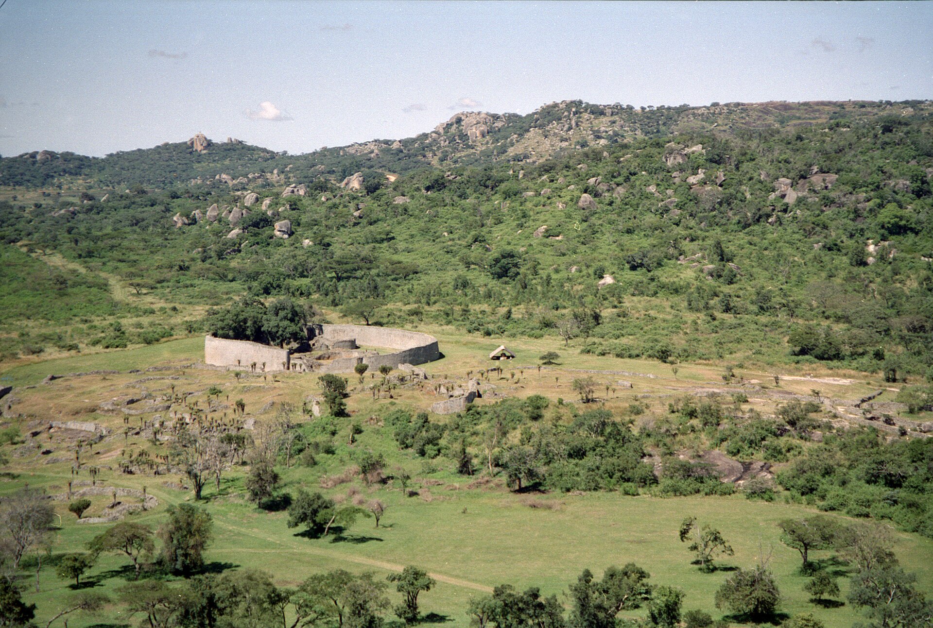
Great Zimbabwe is a city built by African communities in the granite hills near Masvingo. Its most photographed wall belongs to a much larger place: the Hill Complex, the Great Enclosure, the Valley Enclosures, and the houses and work areas that extended beyond their stone boundaries. The architectural remains were made and remade over centuries. A visitor who sees only the tall grey masonry misses earthen houses, terraces, cattle and crop work, carving, metalworking, water sources, and routes through which people moved. The word “ruins” describes what survives, not the scale of the inhabited city. [1], [2], [3], [4], [5], [18], [20]
The building tradition is associated with Shona-speaking ancestors and wider southern African societies, not with the foreign founders imagined by nineteenth-century colonial writers. The name is often related to dzimbabwe or madzimbabwe, stone houses or stone-built centres, though its forms and etymologies are discussed differently by scholars. That uncertainty about a word should not be confused with uncertainty about the builders. Local pottery, settlements, dated deposits, quarrying and living knowledge of dry-stone masonry place Great Zimbabwe within African histories. [1], [2], [3], [4], [5], [10], [14], [18]
The surviving stone is not an untouched photograph of the past. Residents repaired and expanded masonry; antiquarians destroyed archaeological layers; colonial curators removed floors, blocked entrances or rebuilt walls; later Zimbabwean conservators have worked to hold unstable fabric together. Modern names such as “Royal Hill,” “Queen’s Valley” and “Temple” can be useful directions on a map, but they do not identify every building's original occupants or purposes. Great Zimbabwe becomes more intelligible when a wall is read beside its floor, slope, objects, water and successive alterations. [4], [5], [6], [10], [18], [19], [20]
At a Glance
- PlaceA granite-built city and cultural landscape near Masvingo, Zimbabwe, with Hill, Great Enclosure, Valley and peripheral settlement areas. [1], [2], [4], [20]
- BuildingDry-stacked local granite walls, terraces and passages stood alongside many dhaka earthen houses, floors, granaries and fittings, both inside and beyond the stone precincts. [2], [5], [10], [11], [18], [20]
- Time depthEarlier Hill occupation preceded much of the monumental walling. Stone construction probably began by the late twelfth or early thirteenth century; the city flourished especially in the fourteenth and fifteenth centuries, while some Valley and unwalled settlements continued into the sixteenth and seventeenth. These are broad phases, not dates for individual walls. [3], [4], [5], [6], [8], [9], [12], [20]
- Great EnclosureA curving outer wall of roughly 250–252 metres in circuit, rising up to about 10–11 metres in surviving/recorded stretches, with a narrowing parallel passage and a solid conical tower about 10 metres high. The tower's specific function is not established. [2], [5], [13], [18]
- Making a livingLocal farming, livestock, pottery, spinning, carving and distributed metalworking coexisted with regional and Indian Ocean-linked exchanges. Imported things were part of the city's history, not the sole basis of its wealth or proof of foreign builders. [4], [5], [9], [12], [15], [20]
- PeopleNo secure census exists. Older claims of 18,000–20,000 simultaneous residents conflict with phase-sensitive household estimates; the settled area shifted and open space was part of the city. [1], [3], [13], [20]
- Water and landSprings, terrain, rain and some excavated clay pits that may also have stored runoff form a wider environmental architecture; the number and dates of all ancient reservoirs remain uncertain. [7], [11]
- Protection and living heritageInscribed on UNESCO's World Heritage List in 1986; protected by the National Museums and Monuments of Zimbabwe. Masonry skill, local custodianship, springs and sacred groves remain consequential to its care. [1], [2], [10], [11], [17], [18]
Contents
- A city larger than its famous walls
- Centuries of construction, occupation and change
- Climbing the Hill: terraces, boulders and routes
- Granite, coursing and the mechanics of walls
- The Great Enclosure: circuit, passages and tower
- Valley enclosures and the settlements between
- The earthen architecture that stone photographs omit
- Work, food and the materials of wealth
- Circulation without a foreign-builder story
- Carved birds, displaced objects and living symbols
- Population: why a number is not a census
- Springs, clay pits and a managed landscape
- After the fifteenth century
- Colonial damage and the work of conservation
- Monument, shrine and inherited landscape
A city larger than its famous walls
The Hill Complex rises about 80 metres above the surrounding ground. Its granite boulders, terraces and enclosed spaces overlook the Great Enclosure and the more dispersed stone groups in the Valley. Beyond them, walls, house floors, middens, pottery and slag show settlements that older plans and tourist itineraries rarely represented. Two broad perimeter lines and scattered structures complicate any attempt to draw the city as three isolated attractions. The administrative World Heritage area is approximately 720–729 hectares in different institutional records; this is not the exact footprint of buildings occupied at one moment, and the wider cultural and spiritual landscape extends beyond it. [1], [2], [3], [4], [5], [11], [18], [20]
Maps have their own history. A re-mapping study combined older archival plans, aerial images and field visits and found terrace walls missing from common Hill drawings. It traced previously little-reported walls, floors and middens east of the Ridge Ruins for nearly half a kilometre, and it located separated unwalled house clusters around major stone groups. Some floors occur where an older interpretive plan would have left an open “court” for commoners. A vanished enclosure near the former camp is known from earlier sketches and records. These discoveries do not produce a perfect new map: vegetation hides fabric, structures have collapsed, colonial rebuilding has changed lines, and only a small fraction of the broad property had been excavated by the time of that study. They do require the architecture to be understood as more than its postcard core. [18], [20]

Text alternative for the diagram
The Hill lies above the Great Enclosure and Valley groups. Peripheral houses, work areas and walls spread beyond the three main named zones. This is a relational view, not a surveyed perimeter.
Stone boundaries could frame prestige, privacy and movement without defining a class or gender map valid at every date. Floors and objects occur within and outside them. In some precincts a freestanding wall separated a court from a passage; elsewhere masonry retained a hillside platform. The broader network of homesteads supported cultivation, storage and craft work. Open areas between clusters were not necessarily empty gaps: they might carry routes, gatherings, animals or planting, although no excavated field plan reconstructs the use of every open patch. A city with a large political and ceremonial reach need not have packed every hectare with simultaneous dwellings. [3], [4], [5], [18], [20]
Centuries of construction, occupation and change
Occupation on the Hill began before the most imposing surviving masonry. Ceramics, bone, early metalworking traces and fragments of earthen building belong to sequences whose exact early dates remain debated. Bayesian work on a limited set of radiocarbon dates suggests Hill activity and stone construction developing across broad late-first/early-second-millennium ranges. Its modelled 95-percent boundary for a Hill phase spans roughly 1100–1281, and for the Great Enclosure 1226–1383; those are probability windows, not birthdays for the first visible walls. The researchers judge monumental walling likely by the late twelfth or early thirteenth century. A fourteenth- and fifteenth-century crest is a sound broad description, provided it leaves room for overlapping phases and later use. [4], [5], [6], [9], [20]
The site did not simply succeed Mapungubwe after a clean rupture. Revised chronology finds meaningful overlap between the two southern African centres, even if their different political and material histories are still being studied. At Great Zimbabwe itself, Hill, Great Enclosure, Valley and unwalled sites expanded and contracted at different times. Some deposits in the Car Park Midden and elsewhere outside walls postdate use of older central enclosures, while dated porcelain in a sealed Valley context points to occupation there after the much-repeated 1450 cutoff. A Chinese porcelain fragment gives a terminus after manufacture for its deposit, not the day its court was built. Glass-bead types and pottery phases must also be read with stratigraphy rather than turned into a mechanical calendar. [3], [4], [5], [6], [8], [12], [19], [20]

Text alternative for the diagram
Earlier Hill occupation precedes much stone building. Monumental walls develop by the late twelfth or early thirteenth century. Fourteenth and fifteenth centuries bring major urban activity; some Valley and unwalled occupations continue into sixteenth and seventeenth centuries. Individual walls cannot be precisely dated from this diagram.
Older archaeological tables divide occupation into numbered periods. Those categories are useful for comparison, but their borders overlap, and dated samples from disturbed upper layers cannot restore what destructive excavation removed. Generations rebuilt courts and terraces, sometimes directly over older floors. Thus a sector that appears coeval on today's map may contain walls and homes from different centuries. The material record supports a changing urban fabric; it does not permit a single master-plan date or a precise roster of rulers who lived in each enclosure. [4], [5], [6], [18], [19], [20]
Climbing the Hill: terraces, boulders and routes
The Hill is not a naturally level fortress. Granite outcrops supply strength and obstacles. Builders carried terraces across the slopes, filled or bounded them with retaining masonry, and inserted platforms and houses among large boulders. Some wall joints and breaks accommodate irregular foundations or movement in the rock. In the Western area, several metres of superimposed earthen house floors once preserved benches, basins and other moulded fittings. Much of that interior fabric was later lost. A high stone wall was therefore the durable boundary of an inhabited place, not the entirety of its rooms. [2], [5], [18], [20]
The approach also changed with time. Re-mapping located three ancient ascent routes: the familiar Watergate route, a way from the Outspan side towards terraces, and a partly collapsed ascent linked to the Hill precincts. Some paths steered movement between boulders and walls before opening into enclosure groups. The original Western Enclosure had a parallel-passage relationship to an ascent and adjacent courts that twentieth-century safety closures and restorations partly concealed. These findings explain why modern access does not automatically reproduce ancient circulation. It is reasonable to describe directed routes and restricted thresholds; an exact ceremonial procession, person by person, would be invented. [5], [18], [20]
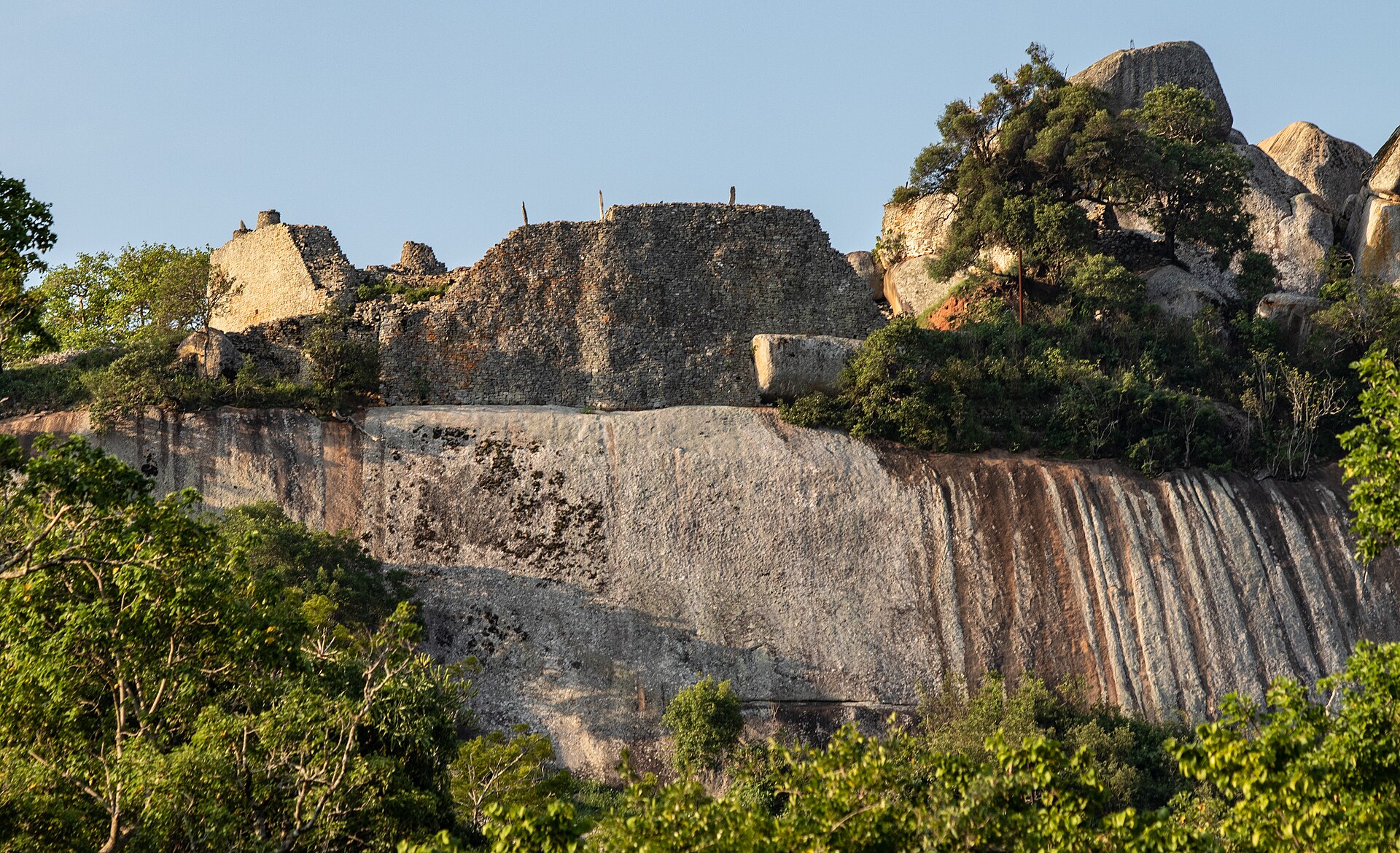
The Hill Eastern precincts are important to the history of the carved birds. Six reported bird finds came from eastern areas and one from a western-facing area. Those places have been disturbed by nineteenth-century removal and later archaeology, so original positioning and associated performances cannot be perfectly recovered. At the same time, the wide distribution of pottery, house floors and masonry shows that “sacred” cannot be opposed to “lived in” as if ritual and household activity were separate species of architecture. Walls could channel visitors, create secluded settings, retain soil and signal authority while everyday work went on around them. [2], [4], [5], [11], [18]
Granite, coursing and the mechanics of walls
Nearby biotite granite weathered into exploitable slabs and blocks. Quarrying drew on local outcrops; percussion was one way to detach and shape stone, and fire may have helped fracture some rock, though its exact ancient contribution cannot be quantified from the finished walls. Masons selected pieces for the visible faces and packed the interior core with care. They did not bind courses with mortar. Gravity, friction, block placement and a strong relation to foundation rock held the construction together. The achievement is better explained through those practical decisions than through a romantic claim that the walls were mysteriously assembled without engineering. [10], [18]

Text alternative for the diagram
Freestanding wall has two visible faces and packed internal stone. A retaining wall has an exposed face, stone core and uphill backfill. This conceptual cross-section is not a structural calculation.
A freestanding wall has two visible, comparatively regular faces enclosing a tightly packed core. A retaining wall uses stone differently, backing a level platform against soil, slope or bedrock. Both can have curved runs, stepped heights or boulder contacts. The mason had to consider not only the weight above a course but the movement of material behind it. The regularity of a face varies from place to place. Archaeologists have described different fabrics with P, PQ, Q and R labels; these describe visible coursing, not four ethnic groups, a single chronology, or an inevitable decline of craft. Repairs were made by the original residents too, so a different-looking patch cannot automatically be called colonial. [5], [10], [18]
Surface ornament is deliberate but unevenly distributed. Chevron bands, herringbone patterns, dentelle-like projections, grooves and standing stones can change a wall's rhythm or emphasise a particular enclosure. Some monoliths seen today were displaced or even added after colonial intervention, so each must be checked against an earlier record. A geometric band may have carried symbolic meaning; the archaeological fabric alone does not license a fixed dictionary translating every chevron into one belief. Its assured architectural effect is to give a high wall texture, direction and visibility as people move past it. [5], [18], [19], [20]
The Great Enclosure: circuit, passages and tower
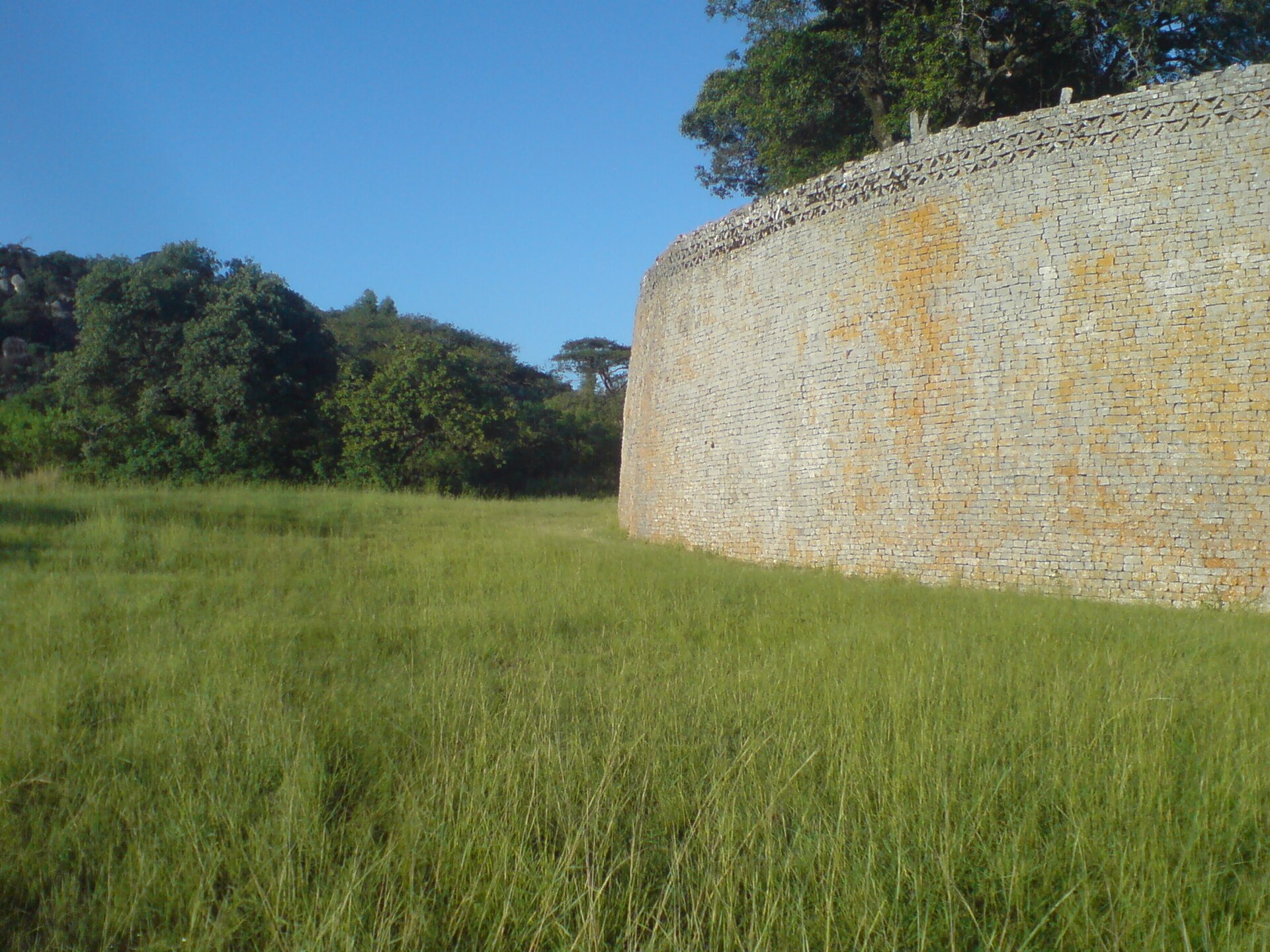
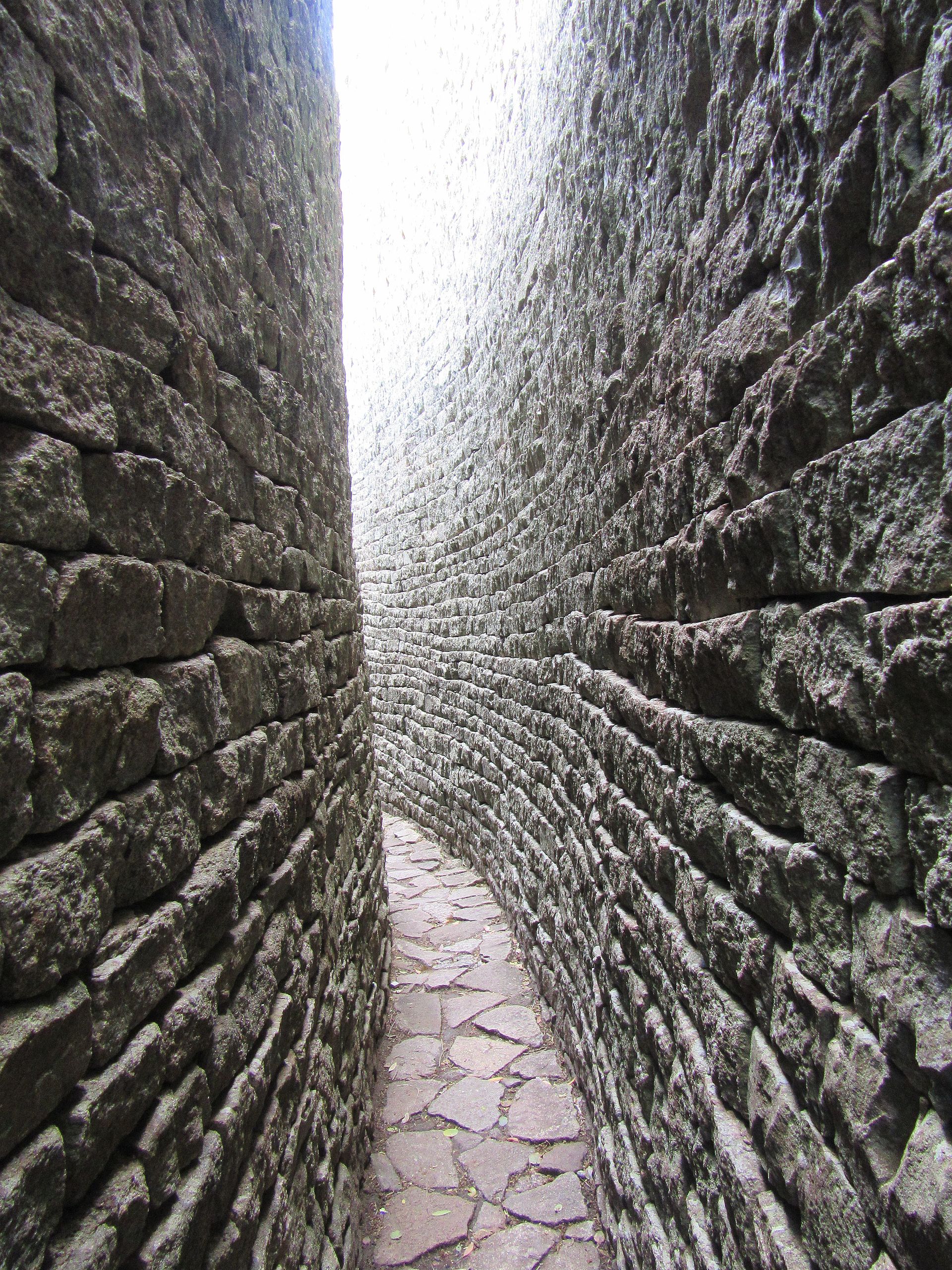
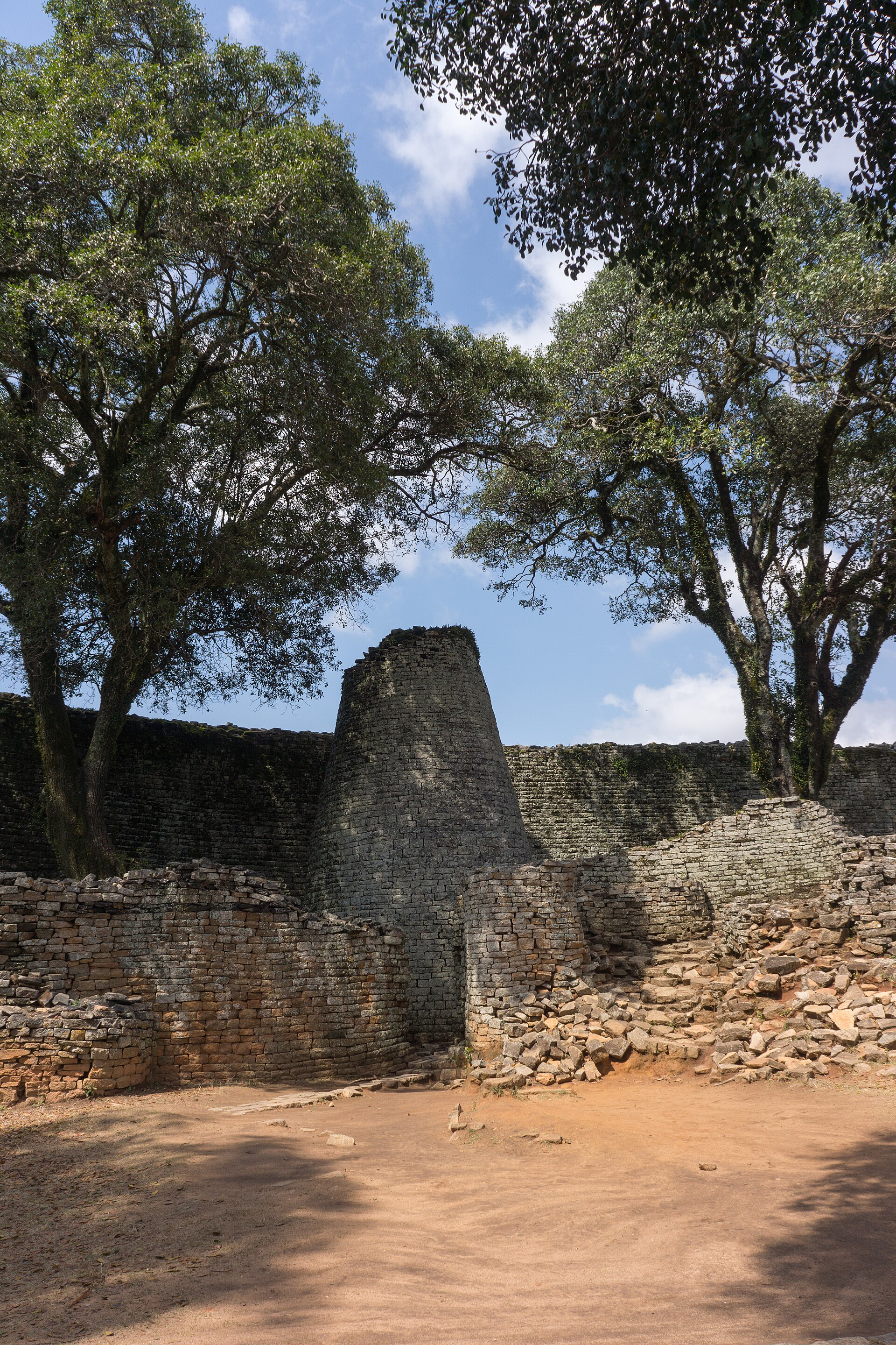
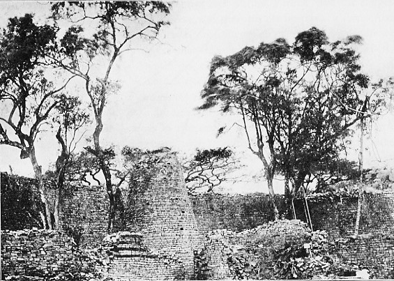
The Great Enclosure is the largest and most familiar stone structure. Its curving outer wall runs roughly 250–252 metres in circuit and reaches around 10–11 metres high in its tallest stretches, with a thick base that narrows upwards. The wall rises around a complex interior of compartments, platforms, entrances and house remains. This was not a single hollow oval with a solitary object in the centre. Multiple thresholds once admitted people; evidence for wooden or stone lintels and rounded entrance ends reminds us that modern roofless openings do not reproduce every original doorway. [2], [5], [13], [18]
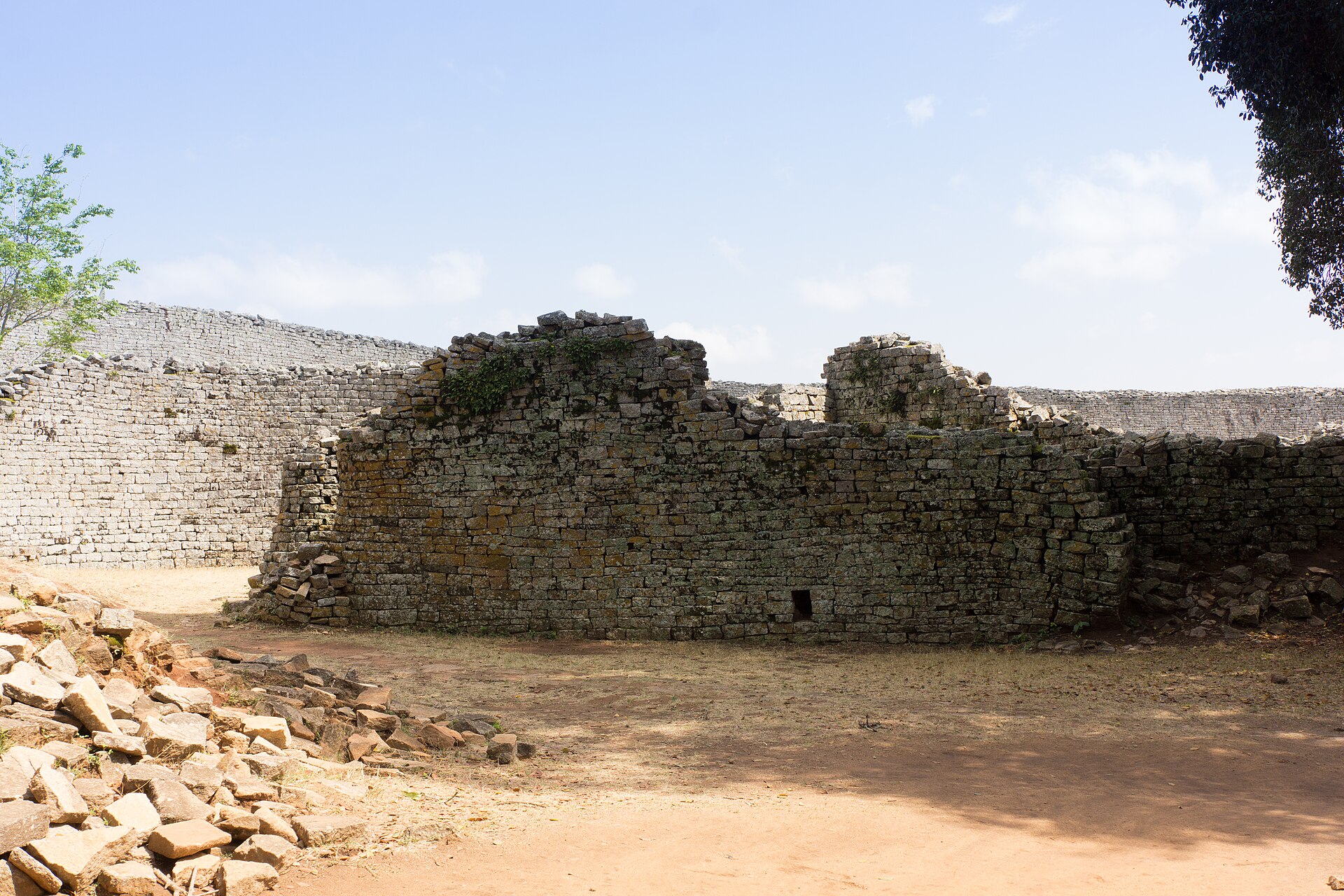
Inside, a curving inner wall and the outer boundary create a narrowing parallel passage that approaches the solid conical tower. Rounded ends and tapering wall projections could control sightlines and how people passed from open court to confined route. Similar design elements occur at smaller scales elsewhere at the site, including some Valley enclosures. The Great Enclosure's monumental effect therefore lies not only in wall height but in the way built surfaces fold movement around courts and restricted paths. There is no recovered route manual specifying who could pass, at what hour, or for which ceremony. [5], [18]

Text alternative for the diagram
A visitor approaches a curved outer wall and a narrowing parallel-walled passage before entering interior compartments near a solid conical tower. It is a relational route, not a measured site plan.
The tower is about 10 metres high and around 5 metres across its base. It is solid rather than a room entered through a doorway. Proposals that it represented a grain store, a ritual emblem or another political sign are interpretations drawn by analogy; none is a documented ancient function. The architecture permits a narrower, stronger observation: builders chose to make a conspicuous vertical form within an enclosed route and court system. To call it a granary as settled fact would ask the tower to provide evidence it does not contain. [2], [5], [13], [18]
Earthen buildings occupied the interior as well as the areas outside the famous wall. Floors, moulded edges and house platforms have survived unevenly; roofing, much domestic walling and ordinary organic furnishings have not. Some stone surfaces may once have been coated in dhaka. The dominant grey of the exposed granite is therefore a conservation-era view of a partially stripped environment, not necessarily the texture and colour encountered by inhabitants. The survival of a high circuit must not make domestic architecture disappear from the account. [4], [5], [11], [18], [20]
Valley enclosures and the settlements between
The Valley contains dispersed, smaller stone precincts, passages and earthen houses. Some exhibit curved wall ends or smaller conical towers, echoing forms from the Great Enclosure without duplicating its scale. Their occupation was not confined to one brief late phase. Artefact contexts, including later imported porcelain and beads, show continuing use after 1450 and overlapping histories that vary by locality. To label the whole Valley as a “Queen's village” is a hypothesis about social organisation, not a room list recovered from floors. [4], [5], [8], [12], [18], [19], [20]
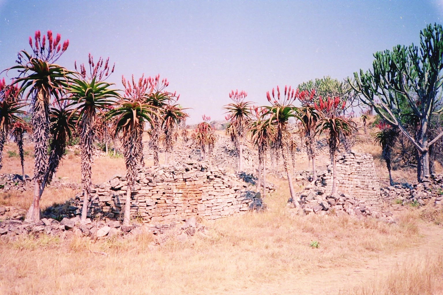
The spaces between stone precincts are as important as the walled courts. Re-mapping identified hut clusters and middens from the entrance side to western areas and behind eastern ruins, with bone, pottery, slag and earthen-building fragments. The eastern Ridge belt and peripheral walls show that the occupied terrain extends beyond conventional visitor routes. Some of these unwalled sites are later than famous walled groups. That time difference defeats an inherited picture in which poor “commoners” permanently lived outside while the same elite household resided inside. Residents outside walls could also acquire glass beads, copper alloys and gold-working materials. Their status, kinship and relationship to enclosure residents must be studied rather than read straight from a wall line. [3], [4], [5], [12], [20]
The city could be a place of gathering and political authority without a dense continuous blanket of housing. Local homesteads may have been dispersed and rebuilt, and some courts and open spaces could host animals, work or occasions that leave fewer floors than a kitchen. The site includes traces of permanent settlement in only about 40 percent of the mapped property in the 2017 demographic study. That finding does not mean the rest was “unused”; it means an estimate of people must not count every wall and hectare as a simultaneously inhabited house. [3], [4], [20]
The earthen architecture that stone photographs omit
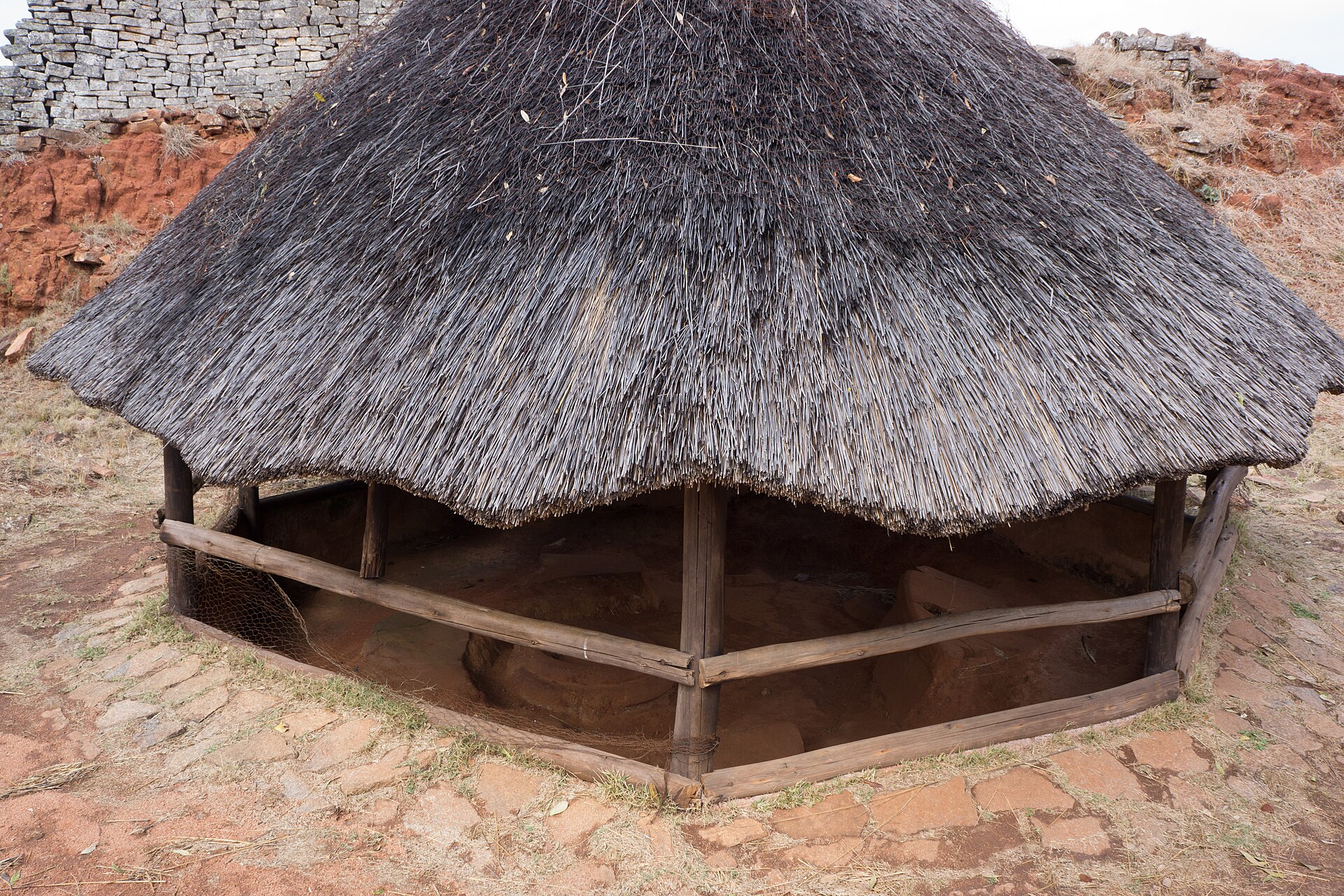
Dhaka was more than a temporary filler between permanent walls. Clay mixed with granite gravel and other material made house floors, walls, moulded benches, kerbs, basins, hearths and granary settings. Repeated floors on the Hill and Valley demonstrate successive construction and domestic repair. Earthen surfaces could cover stone steps or platforms in some precincts, giving a much different appearance from today's exposed courses. Organic roofs and fittings have mostly vanished. The archaeological record remains rich enough to reconstruct the range of work done in and around houses, but not to photograph an exact original room colour or furniture arrangement. [2], [4], [5], [11], [18], [20]

Text alternative for the diagram
Earthen walls, floors, hearths and granary-like fittings formed domestic space between stone walls. Organic roofs often fail to survive. Their particular ancient shapes and occupants are not established by the schematic.
In 1915, some moulded Hill house features were removed under an unsound structural assumption, causing a specific loss of architectural evidence. Earthen material also weathers under rain, heat, runoff and visitor movement. Conservation cannot limit its priorities to spectacular granite: floor layers reveal rebuilding, occupation and living conditions that a stone curtain cannot show by itself. A photograph of an empty-looking enclosure may record the disappearance of perishable walls as much as the absence of inhabitants. [11], [18], [20]
Work, food and the materials of wealth
Finds of charred sorghum and millets, granary traces, grinding stones and cattle, goat and sheep bones place food production and storage within the city's history. Cattle could be economic wealth and social power, not merely meat. Farming, herding and hunting connected stone precincts with land beyond them. No complete ancient field map or harvest ledger survives, so it is not possible to assign a crop, yield or social owner to every open terrace. The evidence does show that the city's prosperity rested on local labour, rain, soil, animals and access to wider landscapes as well as on spectacular buildings. [4], [7], [11], [12]
Pottery was made and used across walled and unwalled areas; cooking, serving and storage all required vessels. Spindle whorls indicate spinning and weaving, though cloth itself seldom survives. Soapstone flakes, bowls, columns, pendants and bird figures show a local carving tradition far wider than one national emblem. Metalworking left slag, crucibles, tuyères and finished objects in multiple settlements. The pattern is consistent with distributed homestead-scale crafts rather than a single royal workshop feeding everyone outside the walls. Work divisions and seasonal circulation remain harder to recover, but an imported object should not overshadow the place where someone fired a pot, spun fibre or prepared a forge. [4], [5], [9], [12], [18], [20]
Recent excavations and material analyses deepen the gold story. More than one hundred fragments of gold-processing vessels from Eastern Ridge and nearby deposits include both purpose-made crucibles and reused domestic pottery. The fragments are made from local clays with properties suited to high heat; analysed gold is mostly natural and unalloyed, with variable source signatures. Different vessel shapes might have supported assay, refining or consolidation, but the whole sequence is an archaeological reconstruction rather than a surviving craft manual. Some gold was worked and valued locally as ornaments or other fittings, even as gold also circulated towards long-distance networks. A laboratory estimate of how much a crucible could hold is not an excavated count of how much the city produced. [4], [9], [15]

Text alternative for the diagram
Homesteads farmed, kept livestock and made objects; regional routes linked communities and metalworking, gold and exchange; some imported glass and ceramics arrived through broader coast-linked networks. The exact route for each object is not drawn.
Circulation without a foreign-builder story
Glass beads, glazed Asian ceramics and other imported materials connect Great Zimbabwe to regional and Indian Ocean routes. Coastal trade linked southern Africa with merchants and commodities from Africa, the Arabian world, south Asia and China, sometimes indirectly across several hands. A Chinese ceramic found inland records the path of a thing, not a Chinese mason at the wall or a direct visit by its maker. A glass bead's composition may locate raw material while leaving the bead's actual manufacturing workshop and final trader uncertain. Many ordinary trading goods were perishable, and colonial removal disturbed others, so present museum numbers cannot be a complete trade ledger. [4], [9], [12], [15]
Beads from both walled and unwalled zones challenge an easy rule that imports were exclusively royal luxuries. The University of Cape Town collections study identifies Khami-series beads in a Car Park Midden late context and local ostrich-eggshell beadwork alongside glass. Imports were valued in specific relationships, not automatically ranked above cattle, land, ancestry or built prestige. There is little archaeological basis for a permanent royal monopoly over all metal production or a single central market. The architecture belongs to a political economy of many homesteads and connected landscapes, not a picture of one high wall guarding the only wealth that mattered. [4], [9], [12], [20]
Carved birds, displaced objects and living symbols
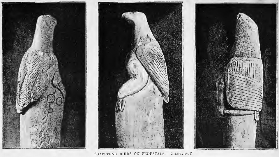
Eight carved soapstone bird figures are associated with Great Zimbabwe: seven reported from Hill precincts and one from a Valley context. Their forms combine birdlike features with shaped columns and details that invite readings of human and avian identity. Their exact ancient meanings, positions and relationships to named rulers have not been recovered. The birds have a secure modern history as symbols of Zimbabwe, but a current national meaning should not simply be projected backwards unchanged onto every ancient ritual. Other soapstone work and making debris place the figures among a wider craft and architectural practice. [1], [2], [4], [5], [11], [13]
One bird's object biography shows how the record was disrupted. Theodore Bent removed it from the Hill's eastern area in 1891 and it travelled with other figures to Cape Town; the originals were returned to Zimbabwe after independence. The British Museum retains a plaster cast made for a 1930 London exhibition. A cast is useful evidence of colonial display and replication, but it is not one of the ancient originals. Some other sculptures advertised historically as site finds have disputed provenance in museum records. Repatriation and careful attribution are therefore part of reading what visitors now see, not side stories to be pasted over a confident but unsupported ancient iconography. [2], [14], [23]
Population: why a number is not a census
Older institutional descriptions still speak of more than 10,000 or about 20,000 people at the same time. Those figures assume a density and coeval occupation not demonstrated by the surviving houses. A 2017 phase-sensitive study mapped permanent settlement traces on roughly 40 percent of the broad property and calculated alternative models from individual structures or clusters treated as homesteads. Even all-coeval upper scenarios range from hundreds to several thousand under different household assumptions. These values are conditional experiments, not a newly discovered true headcount. Occupation moved across precincts; people could visit for gatherings, and archaeological loss obscures many dwellings. Great Zimbabwe was substantial, but a precise simultaneous population cannot be extracted from a wall circuit. [1], [3], [13], [20]
That uncertainty matters to architecture. A very large wall does not require a metropolis crowded around it every night. Courts and gateways could organize dispersed households, political ties, seasonal work and moments of assembly. Nor should a smaller residential model be used to diminish African urban achievement: a city can command a landscape, generate skilled labour and sustain monumental construction while its permanent housing remains distributed and changes over generations. [3], [4], [20]
Springs, clay pits and a managed landscape
Water shaped where homes, work and routes could exist. Springs, including Chisikana, belong to a wider network of catchments, wet places and remembered sacred sites. Recent geoarchaeological work observed excavated dhaka clay pits at the foot of the Hill, some with banks and soil or groundwater conditions consistent with runoff storage. Clay extraction and water collection need not be separate stages in the life of such a pit. This is an architectural connection between earthen house material and the terrain that supplied water. It also adds evidence to older scholarship that had not yet recognised water-management features here. [7], [11]

Text alternative for the diagram
Hill catchments and sloping terrain direct seasonal runoff. Springs supplied water. Excavated clay pits sometimes may also have held runoff. Locations, dates and functions vary and are not mapped here.
Not every depression seen by lidar has been dug and dated. The estimated storage potential of a set of pits is a model from dimensions, not a measured ancient annual water supply, and the precise dates of their excavation or use remain uncertain. Springs have histories that continue into present community practice. The water evidence does not justify a tidy story that one drought “caused” abandonment in 1450, any more than an older absence of excavated reservoirs justified calling the city helplessly arid. A landscape that retains rain, supports vegetation and holds local memory is part of Great Zimbabwe's built environment. [4], [7], [11]
After the fifteenth century
The old statement that the city was wholly abandoned around 1450 because overpopulation stripped nearby forests is too definite. Valley deposits and later unwalled homesteads show occupation continuing into the sixteenth and seventeenth centuries. Political focus may have shifted, some monumental courts ceased to be used in earlier ways, and networks of exchange changed. Competition, climate, environmental pressures and movement could all have contributed, but their weights have not been confidently measured. “Decline” may describe a changing political centre; it should not erase later households, newer pottery or links maintained by surrounding communities. [1], [3], [4], [5], [7], [8], [12], [20]
Later Portuguese accounts of Shona or Mutapa polities are important to regional history, but their chroniclers did not stand inside Great Zimbabwe making plans of its courts. An older scholarly debate associated some reported symbaoe passages with this monument; later archaeological synthesis cautions that the documents do not directly name it. They cannot prove who used a particular Valley courtyard. Dated deposits and building relationships must carry the architectural chronology. [4], [14], [19]
Colonial damage and the work of conservation
Nineteenth- and early twentieth-century explorers carried away objects, excavated without modern records and promoted foreign-builder myths. Their actions removed layers that could have answered questions now unresolved. Subsequent professional archaeology helped establish the city's African history, but conservation and tourism also changed its appearance: entrances were blocked or reopened, walls were rebuilt, vegetation cleared, and earthen floors sometimes removed. Even monoliths visible on the Great Enclosure's wall need individual checking against older photographs and plans. Today's circuit contains ancient work, old residents' repairs, colonial modification and contemporary conservation, not a perfectly frozen fifteenth-century surface. [4], [5], [6], [10], [14], [18], [19], [20]

Text alternative for the diagram
Ancient residents built, repaired and changed walls. Colonial investigators stripped deposits, blocked openings or reconstructed fabric. Zimbabwean custodians and conservators stabilize vulnerable masonry while the site remains a living cultural place.
Stone conservation has structural particulars. Walls can bulge or topple when foundations shift, a core leaks or separates, rainfall undermines bases, or roots penetrate joints. A plant's removal may itself destabilize stones or expose a fragile dhaka surface, while some trees and groves have heritage significance to local custodians. NMMZ conservators, trained masons and local families including the Mugabe masonry tradition examine coursing, movement and soil loss. Photographs, condition records, glass or strain gauges and practical sensory observation each provide different warnings. Rebuilding a picturesque line without fabric evidence could destroy as much information as it saves. [2], [10], [11], [16], [17], [18]
Monument, shrine and inherited landscape
World Heritage status, granted in 1986, recognizes monumental architecture and cultural significance; it does not exhaust what the place means. NMMZ is the national steward. Community histories link Nemanwa, Mugabe, Murinye and Charumbira families, local ritual interests and ancestral relationships to the hills, springs, pools, rivers and groves. Researchers and custodians use terms such as nhaka for inherited responsibility. These are attributed living perspectives rather than a claim that every present ceremony exactly repeats a thirteenth-century rite. Colonial fences and monument management restricted local access; contemporary conversations seek fuller participation, though different communities' claims are not identical. [1], [2], [7], [10], [11], [13], [17], [18]
The conservation question is therefore not merely “how to make a wall straight.” Invasive plants, bushfire, rain, grazing and visitors threaten stone and earthen remains in different ways. A tree can stress a wall yet also belong to a sacred setting. A spring may be relevant to archaeology and to people who still use or honour it. The architecture includes relationships among material, craft, landscape and custodianship, and its future depends on decisions taken with those relationships in view. [2], [7], [10], [11], [17], [18]
Great Zimbabwe's enduring achievement is not that it satisfies a modern image of a dense capital or a mysterious tower. It is the sustained making of a city whose granite courses, earthen homes, terraces, local crafts, regional ties and living landscape cannot be separated without losing the reasons it mattered. Its incomplete record demands care with chronology and meaning, while its surviving construction leaves no doubt about the architectural skill and social reach of the African people who built it. [1], [2], [3], [4], [5], [9], [10], [11], [18], [20]
Related artworks and architecture
The original Zimbabwe birds are associated with the site museum and Zimbabwean stewardship. The British Museum's London-made 1930 cast of Bird 4 is a related object for understanding the original's colonial removal and later return, not one of the eight original bird carvings. Later Shona or Tsonga headrests and Henry Munyaradzi's twentieth-century Zimbabwean stone sculpture are contextual comparisons, not excavated Great Zimbabwe works. Nearby southern African stone-built centres such as Mapungubwe and Khami help show both shared traditions and different histories. [2], [6], [13], [22], [23]
Books and film
Shadreck Chirikure's Great Zimbabwe: Reclaiming a ‘Confiscated’ Past places chronology, households, objects and local ways of knowing together. Webber Ndoro's The Preservation of Great Zimbabwe: Your Monument, Our Shrine is an architectural and conservation study. The Metropolitan Museum of Art's short film about Great Zimbabwe and living stonemasons offers a contemporary visual account of practice and heritage. [13], [18], [21]
Watch: Great Zimbabwe and living masonry
The Metropolitan Museum of Art film introduces the monument and present-day Zimbabwean stonemasons. The Hill photograph shows the steep fabric discussed above; the film is hosted by The Met.
Great Zimbabwe
A short institutional film on historical architecture and continuing stonemasonry.
Editorial photograph: Andrew Moore, source; CC BY-SA 2.0.Explore RELATED Artworks
The bird plate documents displaced carvings in an 1892 publication. The other records describe a later cast and comparative artworks, not site excavation finds.
Zimbabwe birds: historical plate
An 1892 colonial plate of displaced carved birds, not a record of their original positions.
Public-domain historical image; see the article caption and original publication.Zimbabwe Bird 4: London cast
A cast made in London in 1930, not one of the original soapstone birds.
British Museum · link onlySouthern African headrests
Later comparative headrests, not objects excavated at Great Zimbabwe.
The Met · link onlyHenry Munyaradzi sculpture
Twentieth-century Zimbabwean stone sculpture; a contextual comparison, not an ancient site object.
The Met · link onlyFrequently Asked Questions
African communities in southern Africa, associated with Shona-speaking ancestors, built its stone and earthen architecture. Imported objects do not prove foreign builders. [1] [4] [10] [14]
Monumental walling developed broadly from the late twelfth or early thirteenth century and the city flourished in the fourteenth and fifteenth. An exact year for each enclosure wall is not secure. [3] [6] [8]
The tower is solid masonry; its particular symbolic or practical function has not been proven. [2] [5] [13]
No reliable census establishes that. Older high figures conflict with phase-sensitive household estimates and changing settlement areas. [3] [20]
No. Earthen dhaka houses, floors and fittings were widespread inside and outside the walls; organic roofs often did not survive. [5] [12] [18]
Regional farming, livestock and production mattered alongside wider exchange. Imported goods document connections, not a single cause of prosperity. [4] [9] [15]
No. It is an interpretive reconstruction, not an excavated original whose royal occupant or exact roof form is established. [18]
The birds' archaeological positions and later movements are complicated by colonial removals. Historical display plates are not undisturbed site records. [6] [13] [23]
References
- UNESCO World Heritage Centre, Great Zimbabwe National Monument — English property record; French property record
- National Museums and Monuments of Zimbabwe, Southern Region/Masvingo: Great Zimbabwe
- Chirikure et al., “What was the population of Great Zimbabwe (CE 1000–1800)?”, PLOS ONE, 2017
- Shadreck Chirikure, “New Perspectives on the Political Economy of Great Zimbabwe,” Journal of Archaeological Research, 2020; full archival PDF
- Chirikure and Pikirayi, “Inside and outside the dry stone walls,” Antiquity, 2008
- Chirikure et al., “A Bayesian chronology for Great Zimbabwe,” Antiquity, 2013; full author-uploaded text
- Sulas, Pikirayi et al., “Climate-smart harvesting and storing water: The legacy of dhaka pits at Great Zimbabwe,” The Anthropocene, 2022
- Collett, Vines and Hughes, “The chronology of the Valley Enclosures,” African Archaeological Review, 1992 — university record
- Vieri, Chirikure, Lane and Martinón-Torres, “Archaeological science, globalisation, and local agency: gold in Great Zimbabwe,” 2023
- Munyaradzi Elton Sagiya, “Documenting the skills and practices of dry-stone masonry at Great Zimbabwe,” Studies in African Past, 2022
- ICCROM, NMMZ and Great Zimbabwe University, Heritage Place Lab chapter on Great Zimbabwe, 2024
- Pauline Chiripanhura, Archaeological Collections as a Prime Research Asset: Objects and Great Zimbabwe’s Past, University of Cape Town PhD, 2017/2018
- The Metropolitan Museum of Art, Great Zimbabwe essay; 2025 film and report
- Evander Ruthieri da Silva, “Colonialismo e encobrimento de passados africanos,” Diálogos, 2024
- University of Cambridge, Archaeological Science and Globalisation at Great Zimbabwe project
- University of Cambridge, documenting dry-stone masonry knowledge project
- Munyaradzi Elton Sagiya, Center for Critical Conservation interview, 2026
- Webber Ndoro, The Preservation of Great Zimbabwe: Your Monument, Our Shrine, ICCROM, 2005
- Pikirayi and Chirikure, “Debating Great Zimbabwe,” Azania, 2011
- Chirikure et al., “Seen but Not Told: Re-mapping Great Zimbabwe,” Journal of Archaeological Method and Theory, 2017 — full author text
- Routledge, publisher record for Chirikure's Great Zimbabwe: Reclaiming a ‘Confiscated’ Past
- The Metropolitan Museum of Art, headrest 2001.759.1; headrest 2001.759.2; Munyaradzi sculpture 2024.81.2
- The British Museum, cast of Zimbabwe Bird 4, CRS.73
Explore RELATED Architecture
These routes offer architectural comparisons, not a claim that Great Zimbabwe borrowed from every listed tradition.