by Tom Gurney
Tom Gurney BSc (Hons) is an art history expert with over 20 years experience
Email: tomgurney1@gmail.com / Phone: +44 7429 011000
Reading Renaissance Urban Planning
Renaissance urban planning is best understood as strategic intervention in inherited towns, not the sudden replacement of medieval disorder by geometric reason. Fifteenth- and sixteenth-century patrons and designers reshaped selected squares, palace fronts, streets, fortifications and new districts through humanist ideas, revived study of antiquity, perspective and dynastic representation. Ideal-city paintings and treatises imagined comprehensive order; built cities negotiated property, terrain and existing life.[1]
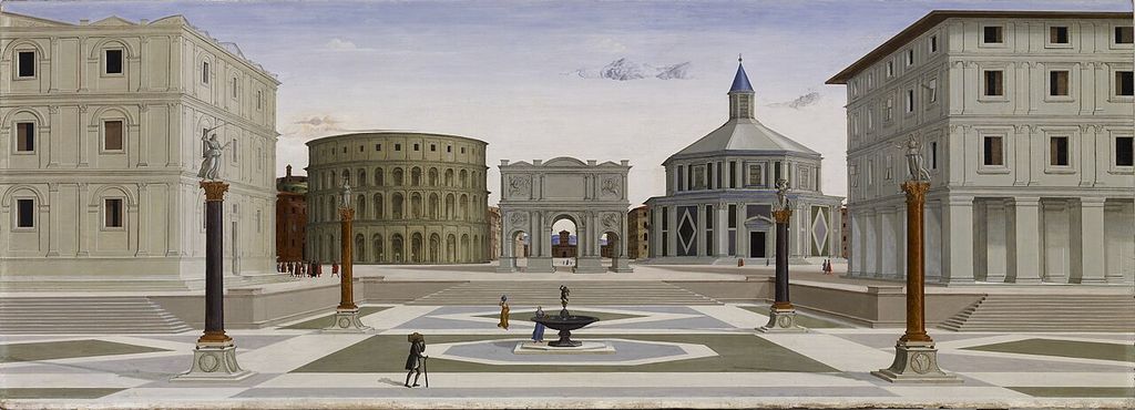
The Ideal City title QS:P1476,en:"The Ideal City " label QS:Len,"The Ideal City " label QS:Lit,"Città ideale" label QS:Lfr,"La Cité idéale" label…. This extraordinary panel exemplifies Renaissance ideals of urban planning, respect for Greco-Roman antiquity, and the mastery of central perspective. In “Reading Renaissance Urban Planning”, this plan helps identify renaissance ideal city plan. The source record gives no dependable image date; visible fabric may include later change. After Giuliano da Sangallo, The Ideal City title QS:P1476,en:"The Ideal City " label QS:Len,"The Ideal City " label QS:Lit,"Città ideale" label QS:Lfr,"La Cité idéale" label…; Public domain. Resized proportionally; no crop, retouch or upscaling.
Pienza, Ferrara and Urbino clarify three different operations. Pienza coordinates a compact papal piazza within an older settlement. Ferrara’s Addizione Erculea adds a major new urban quarter and routes. Urbino’s palace reorganises courtly approach within a hill town. None is simply a perfect grid laid on empty ground.[2][3][4]
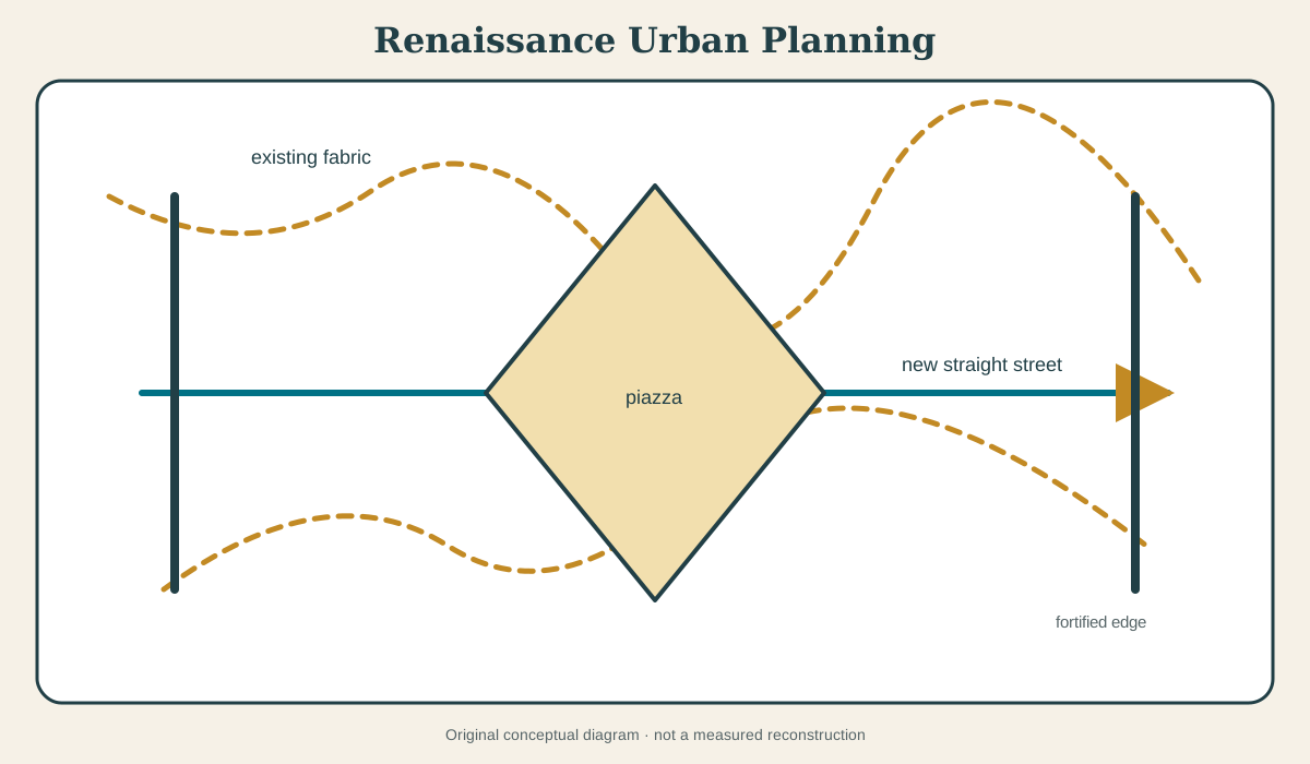
At a Glance
- Periodespecially fifteenth- and sixteenth-century European urbanism.
- Forceshumanist learning, court and papal power, perspective, military engineering, trade and property.
- Common interventionscoordinated piazza, palace frontage, straight street, gate, bastioned edge and planned extension.
- Evidence distinctionideal-city image or treatise records thought; survey, contract and fabric establish construction.
- Essential cautionRenaissance planning modified medieval frameworks more often than it replaced them wholesale.
Contents
- The ideal city on paper and panel
- Pienza: a centre transformed
- Ferrara and the Addizione Erculea
- Urbino: palace and hill town
- Piazza as controlled urban room
- Straight streets and visual connection
- Fortification and the artillery city
- Humanism and concentrated power
- Existing fabric and the myth of rupture
- How to read a Renaissance plan
The ideal city on paper and panel
Renaissance writers and artists reconsidered Vitruvius, ancient cities and geometry. Treatises proposed streets, walls, squares and building types fitted to ideas of health, defence and civic order. Paintings known as ideal-city panels present empty, perspectivally unified urban spaces lined with classicising architecture.
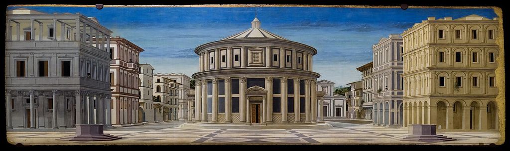
Urbino Renaissance urban view. Ideal City, Unknown Author, 1470-1480 Galleria Nazionale delle Marche, Urbino Oil on panel, 67 x 238.5 cm This perspectival city view, known worldwide as the Ideal City , is perhaps the most emblematic work of…. In “The ideal city on paper and panel”, this plan records the form, material and setting discussed in the passage. Source image dated 2026; that date records the image, not the original construction. Julian Lupyan, Urbino Renaissance urban view; CC0. Resized proportionally; no crop, retouch or upscaling.
These images are powerful evidence for imagination. They make the viewer’s eye central, organise façades around vanishing points and present civic space as harmonious composition. Their emptiness turns social conflict into formal calm.
They are not measured master plans for all Renaissance cities. A painted square may combine buildings that could not function together. A treatise diagram tests principles without identifying land ownership or budget. The historian asks how concepts entered particular commissions.
The gap between ideal and built is productive. A patron could regularise one piazza façade and invoke total order while streets behind remained irregular. Perspective became a political image even where implementation was partial.
Pienza: a centre transformed
Pope Pius II transformed his birthplace, Corsignano, into Pienza. UNESCO identifies the historic centre as an early application of Renaissance humanist urban concepts.[2] The intervention concentrated around a compact piazza with cathedral, papal palace, bishop’s palace and civic building.
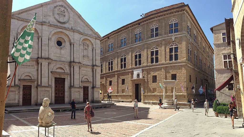
Pienza Piazza Pio II aerial. Piazza Pio II im Zentrum von Pienza (Toskana, Italien). In “Pienza: a centre transformed”, this view records the form, material and setting discussed in the passage. Source image dated 2013; that date records the image, not the original construction. Oschirmer, Pienza Piazza Pio II aerial; CC BY-SA 3.0. Resized proportionally; no crop, retouch or upscaling.
The square is trapezoidal rather than a perfect rectangle. Its geometry responds to site and uses perspective to organise perception. Travertine paving and façades create coherence. Openings towards the landscape connect civic-religious centre to territory.
The project did not rebuild the whole town. Existing streets and houses remained around the new focus. This selective transformation is precisely why Pienza matters: a concentrated architectural ensemble could rename and re-present an inherited settlement.
Papal patronage shaped the programme. Humanist order served dynasty, church and personal commemoration. The “ideal” centre was not politically neutral or universally accessible.
Ferrara and the Addizione Erculea
Ferrara offers a larger extension. Under Duke Ercole I d’Este, Biagio Rossetti’s Addizione Erculea expanded the city northward with major streets, new blocks, palaces and fortifications. UNESCO recognises Ferrara as a Renaissance city tied to its Po Delta territory.[3]
The extension connected to older fabric rather than erasing it. Broad routes intersected at important palace corners and created development capacity. The famous crossing at Palazzo dei Diamanti shows how building detail and urban node reinforce one another.
The plan served defence, growth and ducal representation. New artillery conditions influenced walls. Property development and court patronage determined build-out. Empty blocks on a plan filled over time and unevenly.
Ferrara complicates the idea that Renaissance urbanism focused only on a single square. It coordinates district, street and territorial edge, while still depending on the medieval city beside it.
Urbino: palace and hill town
Urbino’s historic centre is recognised by UNESCO for its Renaissance culture and remarkable adaptation to a hill site.[4] The ducal palace is both architectural complex and urban intervention.
Terrain prevents a simple flat grid. Routes climb; façades address different levels; the palace’s towers create a distant image while courtyards order interior life. Service, court and ceremonial approaches interweave.
Federico da Montefeltro’s patronage gathered architects, artists and humanists. The palace represented learned rule, but it also functioned as household and administration. Urban form made the court visible within existing settlement.
Urbino demonstrates why plan needs section. Perspective, view and skyline emerge from topography. The Renaissance city could be geometric without being flat or orthogonal.
Piazza as controlled urban room
The piazza concentrated civic and representational life. Cathedral, palace, loggia and municipal building established edges. Paving unified the ground. A monument or well provided focus. Italian urban historiography places this space within a much longer civic history rather than treating it as a Renaissance invention.[5]
Renaissance intervention often regularised the visual room more than property behind it. New façades aligned openings and cornices across older plots. The coherent edge could conceal incremental construction.
Perspective influenced approach. A street frames a palace; a trapezoid makes a façade seem larger or nearer; a controlled corner releases a view. Geometry was experienced in motion.
Markets, processions and daily use continued within monumental settings. A piazza is not an empty composition. Regulation determines which uses remain visible.
Straight streets and visual connection
Straight streets existed long before the Renaissance. What changes in certain projects is their deliberate use to link monuments, gates and courtly routes within a perspectival culture.
Opening or widening a street required property acquisition and demolition. Existing routes constrained alignment. The finished vista could therefore be shorter, bent or incomplete relative to proposal.
Façade regulation reinforced continuity. Cornice lines and building heights made the street a composed channel. Palace corners became urban events.
The street also moved goods, soldiers and processions. Visual and practical functions should not be separated. A ceremonial route that congested market traffic could generate conflict.
Fortification and the artillery city
Gunpowder artillery changed city edges. High thin medieval walls were vulnerable; lower, thicker bastioned systems created angular projections and broad defensive zones. Fortification became geometric and territorial.
The ideal-city diagram often combines radial streets with star-like walls. In built towns, terrain, old walls and finance produced irregular adaptations. Military engineers became important urban actors.
Bastions consumed land and required clear fields of fire. Suburbs could be demolished. Gates concentrated routes and became monumental façades. Defence and representation met at the edge.
Fortifications also limited growth. Later expansion breached or converted them into boulevards. Their geometry can survive in ring roads and property lines.
Humanism and concentrated power
Renaissance humanism valued ancient texts, civic history and cultivated patronage. Urban projects displayed this learning through inscriptions, orders, proportion and references to Roman precedent.
The “humanist city” was not automatically democratic. Popes, dukes and oligarchies used design to consolidate rule. Pienza served Pius II’s memory; Ferrara served Este defence and expansion; Urbino served Montefeltro court.
Patrons depended on surveyors, engineers, masons, property holders and labourers. A named architect coordinated only part of the process. Urban authorship is institutional.
Residents adapted new spaces through trade and dwelling. Their use could fulfil, ignore or resist the representational programme.
Existing fabric and the myth of rupture
Calling medieval towns chaotic made Renaissance intervention appear necessary and modern. Actual projects relied on medieval streets, markets, walls and property. New buildings reused foundations and materials.
The contrast between “organic medieval” and “rational Renaissance” is therefore historiographic. Both periods planned; both produced irregularity and adaptation. What changed were particular forms of representation, knowledge and power.
Treccani’s Italian-language urban-history entries help locate città and piazza within longer histories rather than an abrupt rebirth.[1] Local terminology matters because later English summaries can make “Renaissance city” too stylistically neat.
The strongest account dates each intervention. A Renaissance façade, medieval plot and Baroque street can coexist in one block.
How to read a Renaissance plan
- Separate treatise, proposal and built survey.
- Map pre-existing streets, plots and topography.
- Identify patron, legal authority and finance.
- Trace piazza edges, monument views and street widening.
- Include fortification and territorial routes.
- Record demolition, incomplete build-out and later campaigns.
- Compare aerial plan with pedestrian sequence and section.
Ask what portion of the city the project actually transformed. A coherent centre can be significant without being total.
Conservation and layered centres
Renaissance urban ensembles survive because later cities reused them. Façades changed; ground floors opened; traffic occupied squares; walls became roads. Conservation must manage living use.
Protecting visual coherence can conflict with accessibility, housing and commerce. Restricting vehicles may restore pedestrian experience while shifting traffic elsewhere. Tourism can empty centres of residents.
Archaeology beneath paving may reveal earlier market and street lines. Repairs should not erase those layers to present one ideal date. Interpretation can overlay phases digitally.
New architecture need not imitate Renaissance forms. It should understand scale, plot, material and view. A false historical façade may preserve appearance while weakening urban legibility.
Renaissance planning matters because it made selected urban relationships newly self-conscious and representational. Ideal geometry was powerful, but the built achievement lies in negotiation: paper with property, perspective with slope, palace with town, new district with old streets. That tension produced cities richer than the ideal panels’ immaculate emptiness.
Pienza: an urban centre made through relationships
Pienza's transformation under Pope Pius II concentrated on a small group of buildings and a piazza within an existing hill town.[2] Cathedral, papal palace, episcopal palace and town hall define one another through controlled façades and the tapering open space between them.
The piazza's geometry is not a freestanding ideal diagram. Limited ground, existing streets and the view over the Val d'Orcia shape it. Perspective effects make a compact space appear more expansive, while the cathedral's position links civic centre to landscape.
Patronage was biographical and political: the pope remade his birthplace as a humanist image. That concentration left inherited fabric beyond the centre, demonstrating selective intervention rather than total Renaissance replacement.
Ferrara and extension at city scale
Ferrara's Addizione Erculea expanded the city through new streets and districts under Duke Ercole I, associated with Biagio Rossetti.[3] The project is often called an early modern master plan, but its interest lies in joining new geometry to the existing city and fortifications.
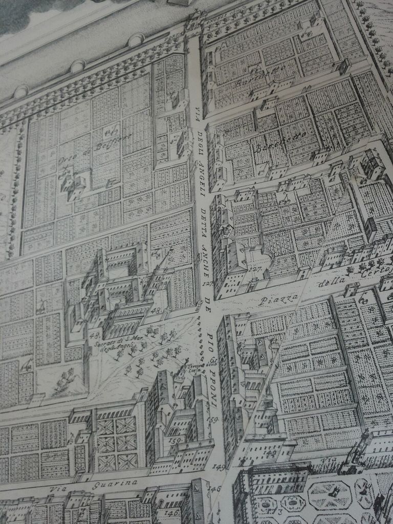
Andrea Bolzoni view of Via degli Angeli, Ferrara. Via degli Angeli detta anche dei Piopponi. In “Ferrara and extension at city scale”, this view records the form, material and setting discussed in the passage. Source image dated 1747; that date records the image, not the original construction. Andrea Bolzoni, Andrea Bolzoni view of Via degli Angeli, Ferrara; Public domain. Resized proportionally; no crop, retouch or upscaling.
Long streets create visual connections, while important buildings punctuate corners rather than terminating every axis. The Palazzo dei Diamanti uses its prominent intersection to address movement in more than one direction. Urban architecture and parcel development carry the scheme beyond a line drawing.
Growth was not instantaneous. Planned ground filled over time, and economic conditions shaped occupation. A spacious street at inauguration and a mature built corridor are different urban states.
Urbino: palace as topography and urban hinge
Urbino's ducal palace occupies steep terrain and presents different faces to city and landscape.[4] Courtyard, façade, ramps and service routes integrate court life with a hill town whose fabric was not erased. The palace is both object and urban mechanism.

Panorama of Urbino. Panoramic view of the town of Urbino in Italy from a vantage point southeast of the city on a hill The two towers of the Palazzo Ducale (Ducal Palace) are visible to the left, the cupola and tower of the cathedral…. In “Urbino: palace as topography and urban hinge”, this view records the form, material and setting discussed in the passage. Source image dated 2007; that date records the image, not the original construction. Florian Prischl, Panorama of Urbino; CC BY-SA 3.0. Resized proportionally; no crop, retouch or upscaling.
The celebrated ideal image of the court can obscure back-of-house systems and workers. Stables, kitchens and circulation supported ceremonial rooms. Federico da Montefeltro's humanist patronage rested on military and territorial power.
Views from the palace make surrounding land part of representation. As at Pienza, humanist urbanism connects controlled centre to a larger territory rather than stopping at the square.
Ideal cities: instruments of thought
Painted panels and treatises proposed geometrically ordered streets, centrally placed monuments and controlled perspective. They made the city available to a single viewing intelligence. Their emptiness and completeness differ from occupied urban fabric.
These images influenced architectural imagination, but resemblance does not prove direct execution. An ideal plan can clarify principles, legitimise a ruler or train designers without becoming a construction document.
Treccani's broader history of the city helps place Renaissance ideas within longer continuities rather than as invention from nothing.[1] Roman precedents, medieval communes, military needs and commerce remained active.
Fortification and the geometric perimeter
Artillery changed the design of walls, bastions and fields of fire. The fortified city acquired angular projections and open ground beyond its perimeter. Geometry served military calculation as well as humanist order.
Defence constrained expansion and consumed land. Gates concentrated movement; walls separated city from suburbs; rebuilding required taxation and specialist engineers. A star outline seen from the air represents a lived regime of access.
Some ideal-city plans merge radial streets with fortification so neatly that later readers treat the geometry as pure aesthetics. Recovering weapon range, earthwork and garrison restores its practical and coercive dimensions.
Street straightening and property negotiation
Opening a visual connection through an existing town required acquisition, demolition and façade control. Even modest projects produced irregular remnants where plots resisted the new line. The finished street can conceal negotiation behind a continuous frontage.
Straightness also had social effects. It improved movement and ceremonial view, exposed buildings to surveillance and raised land value. Benefits were not evenly distributed.
Construction records and cadastral sequence matter more than a retrospective plan. They show whether the street was cut at once, widened gradually or completed through later rebuilding.
The afterlife of Renaissance unity
World Heritage designation often values coherent Renaissance character, but Pienza, Ferrara and Urbino continued through Baroque, industrial and modern periods.[2][3][4] Infrastructure, tourism and housing now occupy their historical frameworks.
Restoring visual unity can remove shop signs, everyday adaptation or later fabric. Conversely, uncontrolled services and traffic can destroy the spatial relationships that make the intervention legible.
Conservation should protect plan, plot, view and social continuity together. The Renaissance contribution is strongest when visible as a transformative layer within a living city, not as a stage set from which later centuries have been cleaned away.
Print and the mobile urban idea
Plans, views and treatises allowed rulers and designers to study cities they had not visited. Print stabilised proportions and made comparison easier, but it also selected monuments, straightened streets and suppressed ordinary occupation. The represented city could appear more complete than the built one.
Travel added observation and misreading. A visitor might carry home a piazza composition without its legal or topographic conditions. The receiving project then became a translation shaped by local power.
Tracing a design's source therefore requires dated access to a publication or drawing, not merely resemblance. A generic “Renaissance influence” should be replaced by a plausible channel.
Streets as stages for court and commune
Processions activated routes between gate, church, palace and square. Temporary arches, textiles and crowds altered the permanent city. A street's ceremonial role may be documented more clearly in festival books than in its ordinary building line.
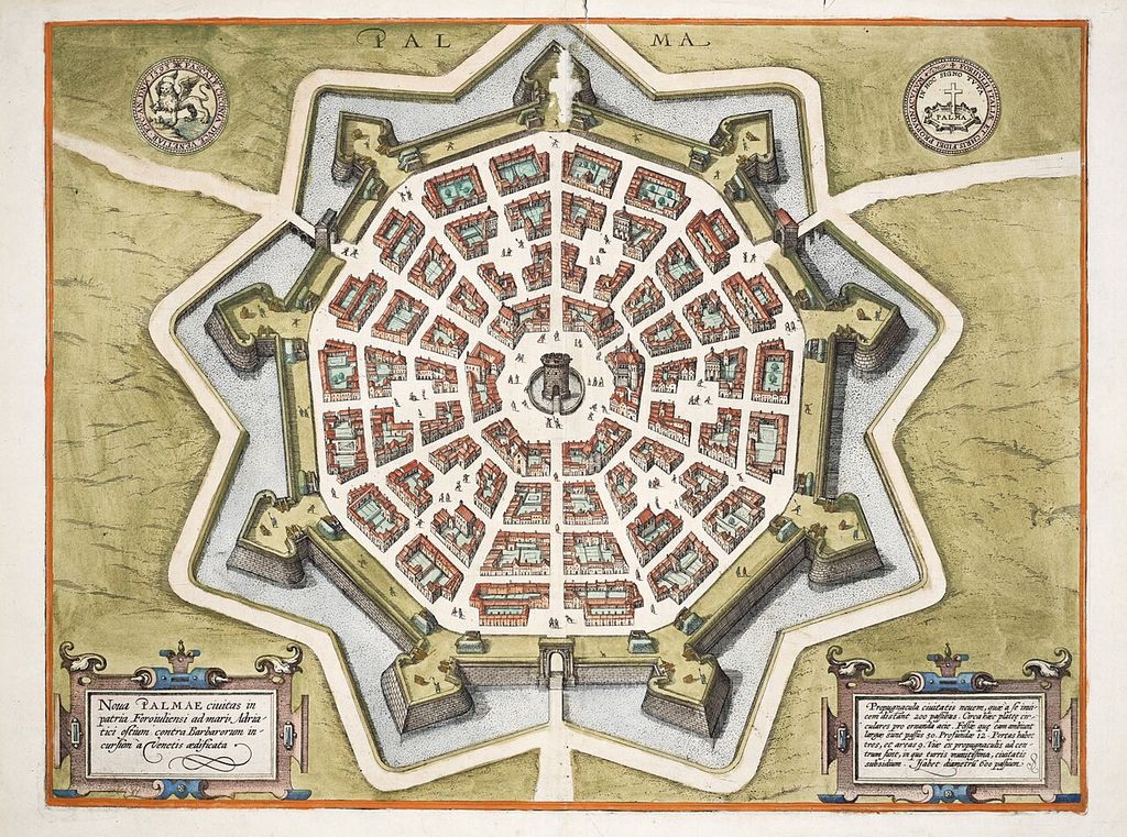
Palmanova map. This map of Palma (Italy) was drawn in 1593 by Joris Hoefnagel(1542-1600), a Flemish painter, printer, illuminator and naturalist. In “Streets as stages for court and commune”, this map records the form, material and setting discussed in the passage. Source image dated 2015; that date records the image, not the original construction. Special Collections Toronto Public Library from Toronto, Canada, Palmanova map; CC BY-SA 2.0. Resized proportionally; no crop, retouch or upscaling.
Commerce and residence continued along the same route. Monumental improvement rarely removed every stall or workshop. Conflict over obstruction reveals competing definitions of urban order.
The Renaissance street was thus neither only perspectival theatre nor only infrastructure. Its historical form joined representation to daily negotiation.
Archaeology beneath the ideal surface
Utility works and excavation can expose earlier walls and streets below a celebrated piazza. These remains show that transformation was built on occupation rather than conceptual blankness. They may also constrain modern services.
Conservation decisions should resist privileging the visible Renaissance layer automatically. A buried Roman route, medieval house and later public surface can all be significant. Documentation and selective display can make stratigraphy legible without turning the square into an open trench.
This multi-period approach corrects the myth of rebirth as clean rupture. Renaissance planning was powerful because it reworked inherited cities.
Rome and the selective straight street
Renaissance Rome offers important interventions before the more comprehensive routes associated with the Counter-Reformation and Baroque city. Popes opened or regularised streets to connect bridges, palaces and pilgrimage destinations. Each project worked through dense inherited fabric.
The straight line improved movement and created façades for elite investment, but completion could take decades. Junctions, surviving fragments and later widening complicate attribution. The transition to Baroque planning is therefore cumulative rather than a sudden stylistic turn.
The New World and colonial foundations
European Renaissance ideas of regularity intersected with Iberian legal traditions and colonial town founding in the Americas. Grids and central squares were instruments of administration, settlement and conversion imposed on Indigenous territories.
Local topography, pre-existing urban cultures and resistance shaped implementation. A superficially regular plan cannot be explained by humanist geometry alone. Law, conquest and land distribution are central.
Comparison should preserve this colonial specificity. Calling every grid a Renaissance ideal city would obscure Indigenous displacement and the distinct institutions that produced colonial settlements.
Surveyors, instruments and units of measure
Plans became buildable through chains, rods, levels, stakes and local units. Survey error accumulated over long streets; property corners required negotiation; sloping ground distorted a geometry drawn on paper.
The material history of measurement explains why implemented form differs from an ideal plan. A small angular shift may be evidence of field practice rather than failure.
Archival dimensions should retain original units before conversion. Modern decimal precision can falsely imply accuracy absent from the source.
Civic improvement and the household scale
New piazzas and palaces changed light, access and value for adjacent homes. Demolition removed some households; façade regulation constrained others. Urban grandeur reached the interior through rents, noise and service routes.
Household records and archaeology can recover this consequence. They show whether a new street supported workshops, elite residence or speculative subdivision after completion.
The Renaissance city is most persuasive when monumental form and ordinary adaptation are read together. The piazza did not float above the lives that financed, built and bordered it.
Water, cleanliness and civic display
Fountains and conduits connected ancient precedent, public provision and political image. Bringing water to a square required sources, gradients and maintenance; the sculpted endpoint made that infrastructure visible. Access might be regulated, and supply could favour institutions or elite districts.
Drainage and paving likewise shaped the admired urban room. A geometrically disciplined piazza still needed to shed stormwater and accommodate markets. Technical works were not separate from humanist representation: they helped a ruler or commune claim competent government.
The source trail should follow both inscription and pipe. One explains the public story; the other reveals the system that made the claim materially credible.
Where supply failed, fountains could remain dry monuments, exposing the gap between civic image and administrative capacity.
The countryside within the planned city
Gardens, orchards and undeveloped plots persisted inside walls and new extensions. They supplied food, absorbed water and reserved land for later growth. An ideal-city image filled with continuous façades can hide this mixed density.
Ferrara's relation to the Po Delta makes territorial ecology especially important.[3] Roads, drainage and agricultural wealth connected urban expansion to a managed landscape. City and countryside were not opposite worlds.
Mapping open ground across time shows whether a planned district failed, developed slowly or intentionally retained cultivation. Empty space needs history before it is called incompleteness.
Building regulations and the coordinated front
Street improvement could govern façade line, height or material while private construction occurred parcel by parcel. The resulting unity was administrative as much as stylistic. Variations in cornice or joint reveal the pace of implementation.
Regulation also addressed fire, obstruction and sanitation. Humanist beauty was one claim among practical urban concerns. Council records may show residents negotiating or evading the rule.
Conservation should protect the relationship between common line and individual plot. Replacing several houses with one large interior can preserve a picturesque façade while destroying the mechanism that produced it.
Watch: three scales of intervention
Choose Pienza—A Renaissance City, Renaissance City of Ferrara or Introduction to Theory of City Form. Together, the films connect architectural form with material, use and historical setting.
Pienza—A Renaissance City
A sustained architectural reading of the papal intervention and its urban setting
Watch on YouTubeDiscussion
Which building or designed landscape most clearly demonstrates Renaissance Urban Planning, and what physical evidence supports that reading?
Reader Insights
Name the material, joint, opening, route or view you can observe.
Give the place, approximate date and a reliable source.
Separate documented history from your interpretation.
Join the Conversation
Share a concise observation or useful source below.
References
- Treccani, “Città,” Dizionario di Storia. View source
- UNESCO World Heritage Centre, “Historic Centre of Pienza.” View source
- UNESCO World Heritage Centre, “Ferrara, City of the Renaissance, and its Po Delta.” View source
- UNESCO World Heritage Centre, “Historic Centre of Urbino.” View source
- Treccani, “Piazza,” Enciclopedia Italiana. View source